Manuals
/
Leica
/
Household Appliance
/
Heat Pump
Leica
GS20
manual
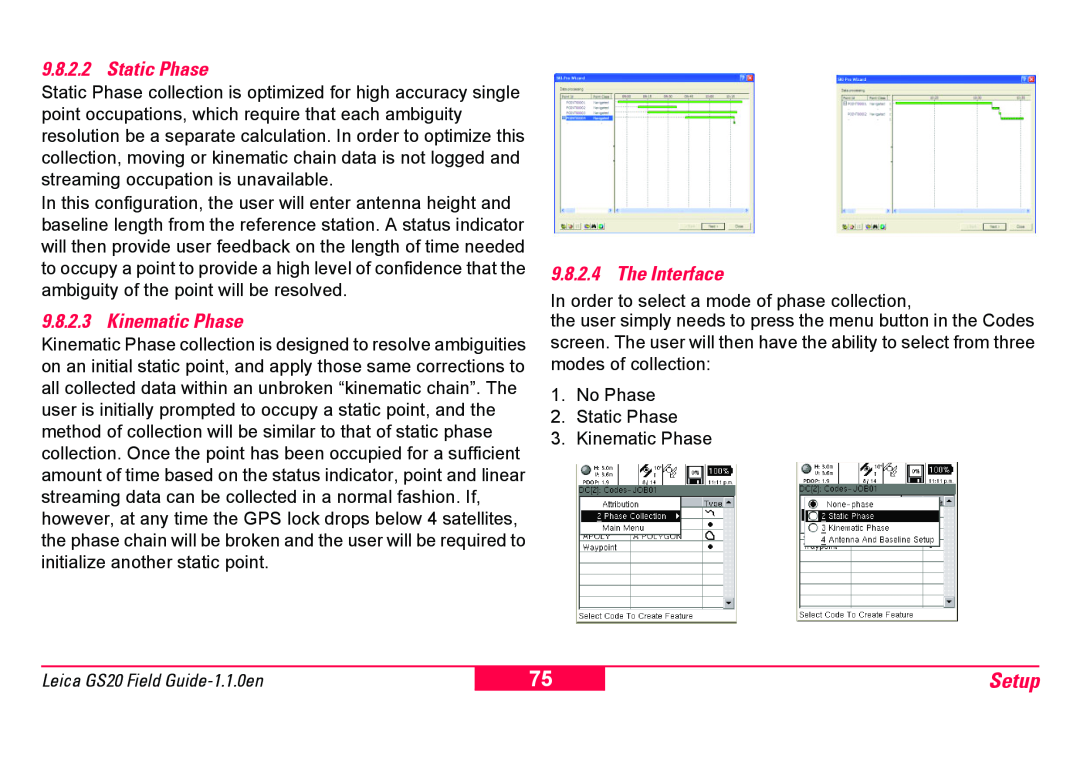
Setup, Static Phase, Kinematic Phase, The Interface
Models:
GS20
1
75
100
100
Download
100 pages
36.34 Kb
72
73
74
75
76
77
78
79
Signal to Noise Ratio
Symbols Used in This Manual
1 Accuracy Indicator
9.3.9Connecting to the Station
Configurations
7.1.2Setup
1.1.1Calibrating the Battery
9.8.2GS20 Phase Wizard
1.4.2Power Key
8.1.3Firmware Update
Page 75
Image 75
Page 74
Page 76
Page 75
Image 75
Page 74
Page 76
Contents
Leica Geosystems GS20
Field Guide
Version
Symbols Used in This Manual
Leica Geosystems GS20
View of chapters
Introduction
Introduction
The Leica Geosystems GS20
Philosophy of Operation
Registration
Registration
Registration
Company stamp, additional notes/information
Leica dealer
2. Data Collection
Table of Contents
Table of Contents
1. Basic Operation
5. Job Management
Table of Contents
3. Data Management
4. Navigation
Utilities
Setup
Table of Contents
7. Applications
12.Index
Table of Contents
10.Status
11.Glossary
Basic Operation
1. Basic Operation
1.1Batteries and Charging
1.1.1Calibrating the Battery
Figure 1-1 Accuracy Indicator
1.2Powering On the Unit
1.3Icons
1.3.1Accuracy Indicator
1.3.4Differential Corrections
1.3.2Stop and Go Indicators
1.3.3Satellite Indicator
1.3.6Battery and Time Indicators
Basic Operation
1.4Button Functions
1.4.2Power Key
1.4.1Alpha Numeric Keys
Basic Operation
1.4.3Enter and Escape
1.4.4Cursor Keys
1.4.5Menu Button
Figure 1-3 GS20 Main Menu
1.4.6The Main Menu
1.4.7Paging
Basic Operation
Figure 1-4 Mapview Selected and Filtered
1.5Software User Interface
1.5.1Map Views
Basic Operation
The map submenu contains zoom controls for
1.5.2GPS Symbol and Zoom Controls
1.5.3Context Menus
Basic Operation
1.5.5.1 Map Filters
1.5.4Tables and Filtering
1.5.5Filtering
Basic Operation
1.5.5.2 Table Filters
Basic Operation
Figure 2-2 Job Management Screenflow
2. Data Collection
2.1Job Management
Data Collection
Data Collection
2.2Background Files in the GS20
2.2.1Overview
2.2.2Adding Background Files to a GS20 Job
Figure 2-4 Creating a background
2.2.4Transferring a background File
Data Collection
2.2.3Creating a Background File in GIS DataPRO
Figure 2-5 Viewing the Map
2.2.5Viewing the Map
Data Collection
Figure 2-6 Turning off the background
2.3Code Management
2.3.1Creating Codelists
Data Collection
2.3.2Using the Codelist Manager
2.3.3Steps for codelist creation
Data Collection
1. Click on Codelist and select New Codelist
Data Collection
2.3.3.3 Step 3 Creating Attributes
Data Collection
Figure 2-8 Transferring Codelists
Figure 2-7 Map Symbology
Data Collection
Facts About Attributes
2.4.3Point Collection
2.4The Codelist and Occupation
2.4.1The Job Codelist
2.4.2Attribution
Figure 2-12 Offset Methods Graphical
Data Collection
2.4.3.1 Point Offsets
Figure 2-11 Example of Dist.Dist O/S
2.4.4Line and Area Collection
Data Collection
Figure 2-13:Line and Area
2.4.5Modes of Collection
Data Collection
Figure 2-14 Attribution screen
Data Collection
3.1.1Options with Nothing Selected
3.1Philosophy of Feature Selection
3. Data Management
3.1.2Options with a Feature Selected
Data Management
3.2Selecting a Feature
3.2.1Feature Management
3.1.3Options with a Node Selected
3.2.1.1 Table Filtering
3.2.3Feature Submenu
3.2.2Selecting a Node or “Vertex”
Data Management
3.2.4Node Submenu
Data Management
3.2.4.1 Re-OccupyingNodes
Data Management
Feature Management
Feature Management
Inserting into a Feature Node Mode
3.3Using the Geographic Clipboard
3.3.1Purpose of the Geographic Clipboard
Data Management
blocks
Data Management
3.3.2Flow of use Sharing a common node between
Data Management
3.3.3Creating Point Topology
Navigation
4. Navigation
Navigation
4.1The Navigation Screen
4.3Creating a new Waypoint feature
4.2Waypoint Selection and Management
Navigation
Navigation
4.4Updating a Navigated Feature
5. Job Management
Job Management
Figure 5-1 New Job Dialog
5.1Coordinate Systems
5.1.1Introduction
Job Management
Figure 5-2 Coordinate System
5.1.2Overview
5.1.3Attaching a Coordinate System
Job Management
5.1.4Field File
Job Management
Geoid Field File
Job Management
Leica GS20 Field Guide-1.1.0en
Job Management
6. Codelist Management
6.1Creating a New Codelist
Codelist Management
6.2Creating a New Code
6.2.1Creating a New Attribute
Codelist Management
7.1.1Introduction
7. Applications
7.1Cultivated Field Control
7.1.2Setup
All identifiers are listed below
Applications
Applications
7.1.3Using the Program
Applications
Select a Tolerance or limit of error
Leica GS20 Field Guide-1.1.0en
Applications
Leica GS20 Field Guide-1.1.0en
Applications
8.1.2Context Menu
8. Utilities
8.1File Browser
8.1.1Browser Controls
Utilities
8.1.3Firmware Update
8.1.4Sensor Transfer
8.1.5Clear System Memory
Setup
9. Setup
Configurations
9.1Selecting, Modifying and Creating
9.3.1Hardware
9.2Tree Directory Navigation
9.3Hardware Management
Setup
9.3.2Contrast
9.3.3Wireless Bluetooth Connectivity
Setup
9.3.3.1 Selecting a Wireless Device
Setup
9.3.4Clearing a Selected Device
9.3.5Real-TimeCorrections with a Mobile Phone
Making the connect
9.3.6Linking with the Bluetooth
9.3.7Configuring your Device
Setup
9.3.8.1 Status Indication
9.3.8Modifying your Configuration
9.3.9Connecting to the Station
Setup
9.4.2Modifying an Existing Template
9.4ID Template Management
Setup
9.4.1Creating an ID Template
9.5.1Creating a New Device
9.5Device Manager
9.6GPS
Setup
9.6.3Antenna Type
Setup
when an antenna has been plugged in or unplugged
9.6.2Minimum Satellites
9.7.1Quality Monitor
9.7Data Collection
Setup
9.6.5Initialization
9.8Interfaces
Setup
9.8.1Real-Time
9.8.2GS20 Phase Wizard
Setup
9.8.2.1 Overview
9.8.2.4 The Interface
Setup
9.8.2.2 Static Phase
9.8.2.3 Kinematic Phase
Leica GS20 Field Guide-1.1.0en
Setup
9.8.3WAAS and EGNOS
Setup
9.8.3.1 Understanding the WAAS Corrections
Setup
9.8.4Connecting to WoRCS Beacon
Setup
9.8.3.2 Changes to the Real-TimeScreen
Setup
9.8.4.1 Powering on the WoRCS
9.8.4.2 Checking the Bluetooth Link
Setup
9.8.4.3 Checking the WoRCS Real-TimeLink
9.8.4.4 WoRCS Real-TimeBeacon
9.8.5Connecting to WoRCS Real-TimeSatellite RTS
Setup
Setup
9.8.5.1 Powering on the WoRCS
9.8.5.2 Checking the Bluetooth Link
Setup
9.8.5.4 WoRCS RTS
Setup
8 Setup
9.8.5.3 Checking the WoRCS Real-TimeLink
Setup
9.8.6.1 Configuration of the GS20
9.8.6Offset Devices
Leica GS20 Field Guide-1.1.0en
Setup
30’00”
Setup
Leica GS20 Field Guide-1.1.0en
Setup
Setup
Double Azimuth or Double Distance
Reverse Azimuth and Distance
Setup
9.8.7ASCII Input
To link an external ASCII Device
9.9.2Language
9.9Units and Formats
Setup
9.9.1Units of Measure
10.1.2 Satellite Information
10. Status
10.1GPS
10.1.1 Position
10.2.1 Real-Time
10.2Interfaces
10.3Hardware
10.1.3 Satellite View
Glossary
11. Glossary
Dilution of precision DOP
Glossary
Longitude
Glossary
Time and Initial Position
Signal to Noise Ratio
RTCM
Selective Availability
12. Index
733607-1.1.0en
Top
Page
Image
Contents