757c, 787c2 and 787c2i GPS Chartplotter Operations Manual
Thank You
Table of Contents
Iii
Introduction to Navigation
Key Functions
Snapshot and Recording X-Press Menu
Sonar X-Press Menu Sonar views only
Navigation X-Press Menu Navigation views only
Table of Contents
Alarms Menu Tab
Chart Menu Tab
Accessories Menu Tab
Setup Menu Tab
Troubleshooting
Views Menu Tab
531528-1A 757c787c2&787c2iManEng.qxp 10/16/2006 1041 AM
How Sonar Works
Peak to Peak measures power output at the highest points
DualBeam Plus Sonar
With optional-purchase QuadraBeam Plus Transducer
QuadraBeam Plus Sonar
With optional-purchase WideSide Transducer
WideSide Sonar
Universal Sonar
How GPS and Cartography Work
531528-1A 757c787c2&787c2iManEng.qxp 10/16/2006 1041 AM
Multi-Media Card MMC/SD Slot
Software Updates
What’s On the Display
Out
Structure where fish may be hiding
Views
Zoom View Chart View
Views available on your Fishing System are Sonar views
Sonar View
Sonar View
Sonar View
Understanding Sonar History
Freeze Frame and Cursor
Real Time Sonar RTS Window
Bottom Presentation
531528-1A 757c787c2&787c2iManEng.qxp 10/16/2006 1041 AM
531528-1A 757c787c2&787c2iManEng.qxp 10/16/2006 1041 AM
Sonar Zoom View
Sonar Zoom View
200/83 kHz Split Sonar View
200/83 kHz Split Sonar View
Big Digits View
Big Digits View
Circular Flasher View
Snapshot and Recording View
Snapshot and Recording View
531528-1A 757c787c2&787c2iManEng.qxp 10/16/2006 1041 AM
531528-1A 757c787c2&787c2iManEng.qxp 10/16/2006 1041 AM
Recording Slider Bar
Position when
Side Beam View
Side Beam View, Default Layout
Side Beam View, Classic Layout
Side Beam View, Slanted Layout
WideSide View
WideSide View
Bird’s Eye View
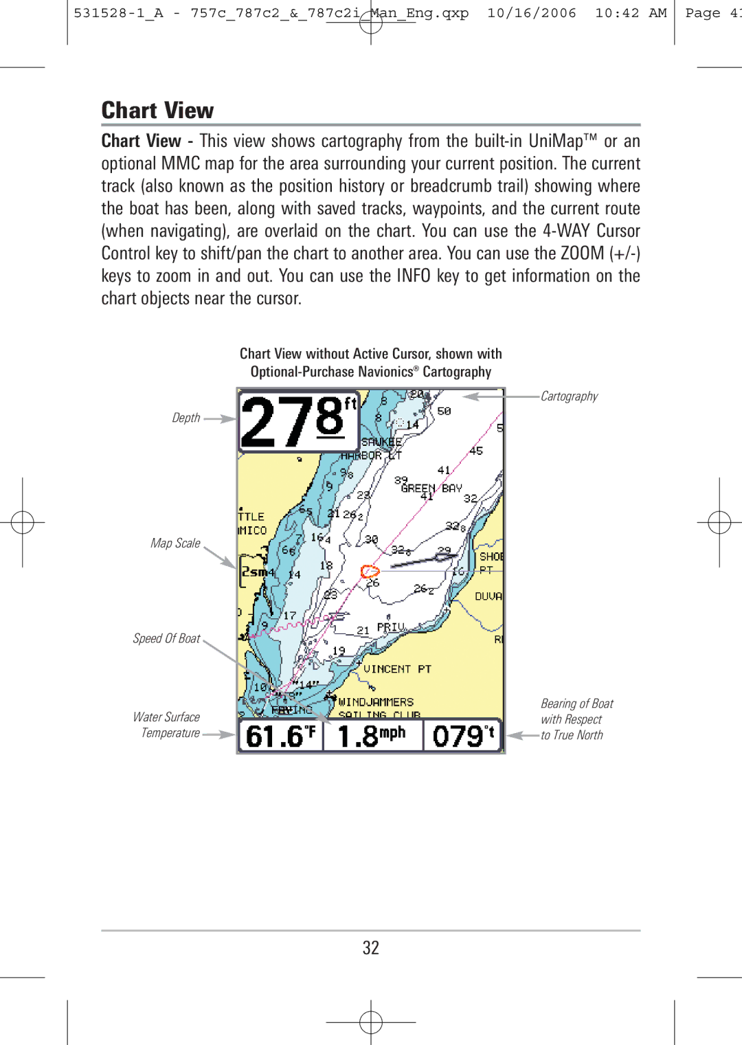
Chart View
Optional-Purchase Navionics Cartography
Chart View with Active Cursor, shown with
Combo View
Combo View
Viewing Cartography
View Orientation
531528-1A 757c787c2&787c2iManEng.qxp 10/16/2006 1042 AM
Waypoints, Routes and Tracks
Introduction to Navigation
Waypoints, Routes and Tracks
Save, Edit, or Delete a Waypoint
Navigate to a Waypoint or Position
Add a Waypoint Target or Trolling Grid
Waypoint Trolling Grid
Save, Edit or Delete a Route
Edit, Delete or Hide Saved Tracks
Save or Clear a Current Track
Man Overboard MOB Navigation
MOB Navigation
View Key
POWER/LIGHT Key
Key Functions
Menu Key
Info Key
Mark Key
WAY Cursor Control Key
Goto Key has multiple functions, depending on the situation
Goto Key
Zoom +/- Key
Exit Key
Accessory Bus
787c2 Title Screen
Powering Up the Unit
Reactivate the X-Press Menu
Menu System
Sonar Tab, Normal Mode Sonar Tab, Advanced Mode
Normal Operation
Exit Normal operation by powering your Fishing System off
Start-Up Options Menu
Simulator shown with optional-purchase Weathersense attached
Simulator
Self Test
System Status
System Status Accessory Test Screen
Accessory Test
GPS Diagnostic View
GPS Diagnostic View
PC Connect with PC Connect cable only
Exit PC Connect mode by powering the Fishing System off
Sonar views only
Sonar X-Press Menu
WideSide transducer WideSide view only
Side
Sensitivity
Upper Range
Lower Range
Side Beam Range
To adjust the Side Beam Range
Quad Layout
Chart Speed
Bottom Lock
Sonar Zoom view only when Bottom Lock is On
Bottom Range
Sonar Zoom view only
Only when Navigating
Cancel Navigation
Navigation X-Press Menu
Navigation X-Press Menu
Navigation views only
Waypoint Submenu
Waypoint Name
Only with an active cursor on a waypoint
Save Current Track
Chart or Combo view only
Cursor to Waypoint
Save Current Route
Clear Current Track
Skip Next Waypoint
Only when Navigating
Only when MOB Navigation is activated
Cancel MOB Navigation
Remove Target
Only if a Target is Active
Sonar Window
Remove Grid
Only if a Grid is Active
Combo view only
Waypoint Name Submenu
Most recently-created waypoint
Snapshot and Recording PressMenu
Snapshot and Recording Press Menu
Snapshot and Recording View only
Stop Recording
Start Recording
To start sonar recording
Optional-purchase MMC/SD Card, Snapshot Recording View only
Delete All Images
Delete Image
Delete All Recordings
Delete Recording
To specify the pings per second
Pings Per Second
Playback Speed
Stop Playback
Sonar Menu
Sonar Menu Tab
Beam Select
Fish ID+
Fish ID Sensitivity
Zoom Width
Bottom View
Advanced
KHz Sensitivity
Advanced with QuadraBeam Plus transducer
To change the 455 kHz Sensitivity setting
Advanced with WideSide transducer
To change the WideSide Sensitivity setting
WideSide Sensitivity
Depth Lines
Depth Lines
Surface Clutter
Max Depth
Noise Filter
Transducer Select
Water Type
Navigation Menu Tab
Navigation Menu Tab
Current Track Submenu
Current Track
Saved Tracks Submenu
Saved Tracks
Waypoints Submenu
Waypoints
Waypoints Submenu contains the following menu choices
Routes Submenu
Routes
Grid Rotation
Chart Orientation
North Reference
Track Min Distance
Trackpoint Interval
Map Datum
Track Color Range
Export All Nav Data
Course Projection Line
To Export All Navigation Data
104
105
Continuous Navigation Mode
Delete All Nav Data
106
Chart Menu Tab
Chart Menu
107
Chart Detail Level
Map Borders
Map Borders
Spot Soundings
Lat/Lon Grid
Navaids on Birds Eye View
109
110
Shaded Depth
Set Simulation Position
Clear Map Offset
Set Map Offset
112
Alarms Menu Tab
Alarms Menu
113
Depth Alarm
Fish ID Alarm
With optional-purchase temp. probe or Temp/Speed only
Low Battery Alarm
Aux Temp Alarm
115
Temp Alarm
Off Course Alarm
116
Arrival Alarm
Drift Alarm Perimeter
Drift Alarm
118
Alarm Tone
119
Setup Menu Tab
Setup Menu Tab
Units Temp
Units Depth
Units Distance
120
Language
User Mode
Units Speed
Restore Defaults
Triplog Reset
Select Readouts
Navigation Triplog Position Voltage Speed Time Temperature
Course
123
124
Default Sonar View Customized Sonar View
125
Depth Offset
Aux Temp Offset
Speed Calibration
Temp Offset
126
Advanced, with Temp/Speed only
Daylight Saving Time
Local Time Zone
Time Format
Position Format
128
Advanced, International only
Digits Format
Date Format
130
Nmea Output
Sonar
Views Menu
Bird’s Eye View Chart View Combo View
Views Menu Tab
133
Accessories Menu Tab
134
Using Screen Snapshot
135
Fishing System Doesn’t Power Up
Troubleshooting
137
Display Problems
Does not exceed 20 Volts
Finding the Cause of Noise
Series Fishing System Accessories
140
Area of Coverage @ -10 dB in 83 kHz 20 @ -10 dB in 200 kHz
Specifications
LCD Matrix V x 240 H 757c 640 V x 480 H 787c2 and 787c2i
Current Draw mA 757c 700 mA 787c2 750 mA 787c2i
142
Sonar Terms
Glossary
144
145
146
147
148
Receiver See Transmitter
149
150
151
152
153
GPS & Navigation Terms
154
155
156
157
158
Contact Humminbird