Your HTC Desire User guide
Before you do anything else, please read this
Page
Trademarks and copyrights
Page
Conventions used in this guide
Contents
Moving the cursor when entering text
Searching the Web and your phone using the Quick Search Box
Adding a new phone number to your contacts from call history
Turning the speakerphone on or off during a call
Sending an SMS/MMS message or email to a group
10
Importing contacts from an Exchange ActiveSync account
Sending your contact information as a vCard via MMS
103
Installing apps from your computer to your phone 118
100
101
121
12
Facebook for HTC Sense and Facebook for Android application
120
157
Reminder settings 166
147
156
169
14
167
168
189
186
187
188
211
16 Disconnecting or unpairing from a Bluetooth device 204
207
209
231
227
Rotating and saving a photo 227 Cropping a photo
228
255
252
253
Editing or deleting a footprint 254
277
Checking the power usage of applications 281
Protecting your phone with a screen lock 272
274
20
283
284
Inside the box
Basics
Your Phone
Front panel
Basics
Home
Basics
Back panel
Bottom panel
Top panel
Left panel
Volume UP
Back cover
Before turning on your phone
Storage card
Battery
Basics
Finger gestures
Basics
Turning off your phone
Setting up your phone for the first time
Getting started
Turning on your phone
Basics
Sleep mode
Basics
Extended Home screen
Home screen
Navigating the Home screen
Phone status icons
Phone status and notifications
Notification icons
Checking notifications
Selecting an item onscreen
Going to an extended Home screen
Moving the cursor when entering text
Selecting a tab
Selecting a link on a webpage
Adjusting the volume
Adjusting the ringer volume
Adjusting the media volume
Connecting your phone to a computer
Copying files to and from the storage card
Searching your phone and the Web
Setting Web and Quick Search Box options
Press Home Search
Searching the Web and your phone using the Quick Search Box
Personalizing
Making your phone truly yours
Changing the ringtone
Using a preset scene
Personalizing your phone with scenes
Personalizing
Personalizing
Customizing and saving a scene
Renaming or deleting a scene
Changing your wallpaper
Adding a widget to your Home screen
Personalizing your Home screen with widgets
Downloading HTC widgets
Personalizing
Adding folders on your Home screen
Creating a new folder and adding items to it
Moving a widget or icon
Renaming a folder
Removing a widget or icon
Calling somebody using your phone
Phone calls
Making calls
Phone calls
Calling a speed dial number
Calling a phone number in a text message
Calling a phone number in an email
Phone calls
Receiving calls
Making an emergency call
Answering an incoming call
Phone calls
Rejecting a call and sending a text message
Rejecting an incoming call
Handling multiple calls
Using in-call options
Setting up a conference call
Muting the microphone during a call
Turning the speakerphone on or off during a call
Ending a call
Using call history
Checking a missed call
Adding a new phone number to your contacts from call history
Clearing the call history list
Call services
Phone calls
Turning Airplane mode on or off
People
About People
Ways of getting contacts into your phone
People
People screen
Setting up My contact card
Your contacts list
People
People
Importing contacts from an Exchange ActiveSync account
Adding a new contact
Merging contact information
Importing contacts from the storage card
Editing a contact’s information
Searching for a contact
Backing up your contacts to the storage card
Sending contact information as a vCard via MMS
Deleting contacts
Contact groups
Sending your contact information as a vCard via MMS
Creating a group and adding contacts
Adding or removing contacts from a group
Deleting a group
Sending an SMS/MMS message or email to a group
Contact information and conversations
People
Adding the People widget
Setting the default communication method
Changing the default communication method
People widget
Getting in touch with a contact
Using the onscreen keyboard
Using the landscape onscreen keyboard
Keyboard
Changing the onscreen keyboard layout
Entering text
Keyboard
Keyboard
Entering words with predictive text
Adjusting touch input settings
Touch Input settings
Entering text with voice input
Qwerty
Text input
Keyboard
About Messages
Messages
Messages
Sending text and multimedia messages
Messages
Messages
Messages
New message notifications
WAP push messages
Managing message conversations
Messages
Protecting a message from deletion
Deleting a message thread
Deleting several message threads
Setting text and multimedia message options
Deleting a single message
Viewing contact details and communicating with a contact
Messages
Messages
Adding the Messages widget
Accounts and sync
Synchronizing with online accounts
Adding a social network account
Accounts and sync
Synchronizing with a Google Account
Synchronizing with a Microsoft Exchange ActiveSync account
Managing your accounts
Accounts and sync
Accounts and sync
Using HTC Sync
Installing HTC Sync
Setting up HTC Sync to recognize your phone
Setting up synchronization
Setting up more sync options
Synchronizing your phone
Installing apps from your computer to your phone
Downloading the latest HTC Sync upgrade
Accounts and sync
Social
Facebook for HTC Sense and Facebook for Android application
Facebook for HTC Sense
Social
Facebook for Android application
Social
Peep screen
Twittering on your phone
Searching for Twitter users to follow
Sending a tweet
Sending a direct message
Adding the Twitter widget
Setting Peep options
Friend Stream screen
Using Friend Stream
Adding the Friend Stream widget
Updating your status
Chatting in Google Talk
Signing in to Google Talk
Chatting with friends
Social
Changing your online status and picture
Managing your Friends list
Options menu, tap Always show friend
Changing Google Talk settings
Indicates that the friend is Using an Android phone
Viewing your Gmail/Google Mail inbox
Using Gmail/Google Mail
Email
Reading your messages
Email
Page
Sending a message
After composing your message, tap Send
Managing conversations and messages
Page
Email
Changing Gmail/Google Mail settings
Adding a POP3/IMAP email account
Mail
Viewing your email inbox
Email
Exchange ActiveSync email
Email
Composing and sending an email message
Viewing and replying to an email message
Editing email account settings
Adding the Mail widget
Deleting an email account
About Calendar
Calendar
Calendar
Creating a calendar event
Calendar
Inviting guests to your event Google Account only
Changing calendar views
Month view
Day and Agenda views
Week view
Viewing, editing or deleting an event
Viewing and editing an event
Deleting an event
Viewing, dismissing, or snoozing event reminders
Calendar event reminders
Showing or hiding calendars
Displaying and synchronizing calendars
Reminder settings
Changing Calendar settings
Calendar view settings
Sending a vCalendar
About the Calendar widget
About the HTC Clock widget
Clock and Weather
Clock and Weather
About the Clock application
Clock and Weather
Using Desk Clock
Clock and Weather
Setting your home city
Using World Clock
Setting the time zone, date, and time
Adding a city to the World Clock screen
Setting the alarm clock
Deleting an alarm
Setting an alarm
Snooze duration
Changing alarm sound settings
Alarm in silent mode
Alarm volume
Checking weather
Adding a city to the Weather screen
Changing the order of cities on the Weather screen
Deleting cities from the Weather screen
Changing weather options
About the Weather widget
Enabling data roaming
Internet
Data connection
Turning the data connection on or off
Wi-Fi
Turning Wi-Fi on and connecting to a wireless network
Internet
Connecting to a Wi-Fi network with EAP-TLS security
Checking the wireless network status
Internet
Connecting to another Wi-Fi network
Adding the Data connection and Wi-Fi widgets
Preparing your phone for VPN connection
Connecting to a virtual private network VPN
Adding a VPN connection
Connecting to a VPN
Using your phone’s web browser
Disconnecting from a VPN
Opening the browser
Setting your home
Going to a web
Changing the screen orientation
Browsing full versions of all web sites
Navigating on a web
Zooming in or out on a web
Link What to do
Selecting a link in a web
Opening a new browser window
Finding text within a web
Switching between browser windows
Copying text, looking up information, and sharing
Downloading applications from the web
Selecting text Press and hold on a word
Viewing bookmarks and previously visited pages
Internet
Setting browser options
Using your phone as a modem tethering
Bluetooth
Using Bluetooth
Turning Bluetooth on or off
Connecting a Bluetooth headset or car kit
Bluetooth
Changing the phone name
Bluetooth
Reconnecting a headset or car kit
Unpairing from a Bluetooth device
Disconnecting or unpairing from a Bluetooth device
Sending and receiving information using Bluetooth
Disconnecting a Bluetooth device
Sending information from your phone to another device
Bluetooth
Receiving information from another device
Bluetooth
Camera
Camera basics
Viewfinder screen
Camera
Using the optical trackball as the shutter release
Review screen
Camera
Zooming
Taking a photo
Your phone’s battery level reaches 15% or lower
Camera flash doesn’t turn on?
You have an incoming call
Capturing a video
Face detection
Image properties
Camera settings
Changing basic settings
Exposure
Widescreen photo mode only
Changing advanced settings
ISO photo mode only
Resolution
Recording length video mode only
Quality photo mode only
Self-timer photo mode only
Geo-tag photos photo mode only
Review duration
Flicker adjustment
Face detection photo mode only
Time stamp photo mode only
Reset to default
Grid photo mode only
Photos
About the Photos application
Selecting an album
Photos
Viewing photos and videos
Browsing in filmstrip or grid view
Photos
Viewing a photo in landscape orientation
Watching video
Zooming in or out on a photo
Viewing photos in your social networks
Viewing photos on Facebook
Viewing photos on Flickr
Working with photos
Rotating and saving a photo
Cropping a photo
Sharing
Sending a photo or video by MMS
Sending photos or videos by email
Sharing photos on Facebook
Sending photos or videos using Bluetooth
Sharing photos on Flickr
Sharing photos on Picasa
Sharing videos on YouTube
Photos
Music
About the Music application
Playing music
Music
Music
Browsing music in the Library
Creating a playlist
Playing the songs in a playlist
Managing playlists
Music
Checking if the song was added as a ringtone
Setting a song as ringtone
About the Music widget
Sending music using Bluetooth
Using Google Maps
Maps and location
Viewing locations
Maps and location
Maps and location
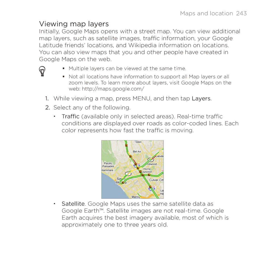
Viewing map layers
Searching for a location
Tap . The search results are displayed on the map
Getting directions
Maps and location
Maps and location
Maps and location
Maps and location
Maps and location
Creating a footprint
Using HTC Footprints
Revisiting a footprint
Exporting your footprints
Editing or deleting a footprint
Adding the Footprints widget
Importing footprints
More apps
Watching videos on YouTube
Watching videos
Searching for videos
Sharing a video link
More apps
More apps
Capturing a video and sharing it on YouTube
Viewing documents, presentations, and spread- sheets
Quickoffice does not reflow text in tables
Keeping track of your stocks
Deleting stock quotes and indices
Setting stock information update frequency
Adding a stock quote or stock market index
Changing the stock list order
Adding the Stocks widget
Manually updating stock information
Sharing a voice clip
Setting a voice clip as a ringtone
Recording your voice
Recording your voice
Using Voice Search
Renaming a voice clip
Opening Voice Search
More apps
Finding and installing apps from Android Market
Finding and installing an application
Creating a Google Checkout account
Requesting a refund for an application
Opening an installed application
Getting help
Uninstalling an application
Protecting your phone with a screen lock
Security
Security
Settings on your phone
Settings
Settings
Settings
Preventing automatic screen rotation
Changing display settings
Adjusting the screen brightness manually
Adjusting the time before the screen turns off
Switching animation effects on or off
Recalibrating the G-sensor
Keeping the screen on while charging the phone
Changing sound settings
Changing the phone language
Optimizing your phone’s battery life
Checking the available storage card space
Checking the power usage of applications
Managing memory
Checking how much phone memory is available for use
Uninstalling third-party applications
Clearing application cache and data
Freeing up more phone memory or storage card space
Checking information about your phone
Performing a hard/factory reset
Reset
Update and reset
Specifications
Specifications
Index
Symbols
Index
Index
Index
Index