– 8 –
•Check this alignment on a celestial object, such as a bright star or the Moon, and make any refinements necessary, using the method outlined above.
With this alignment performed, objects first located in the
UNDERSTANDING CELESTIAL MOVEMENTS AND COORDINATES
Understanding where to locate celestial objects, and how those objects move across the sky is fundamental to enjoying the hobby of astronomy. Most amateur astronomers adopt the simple practice of
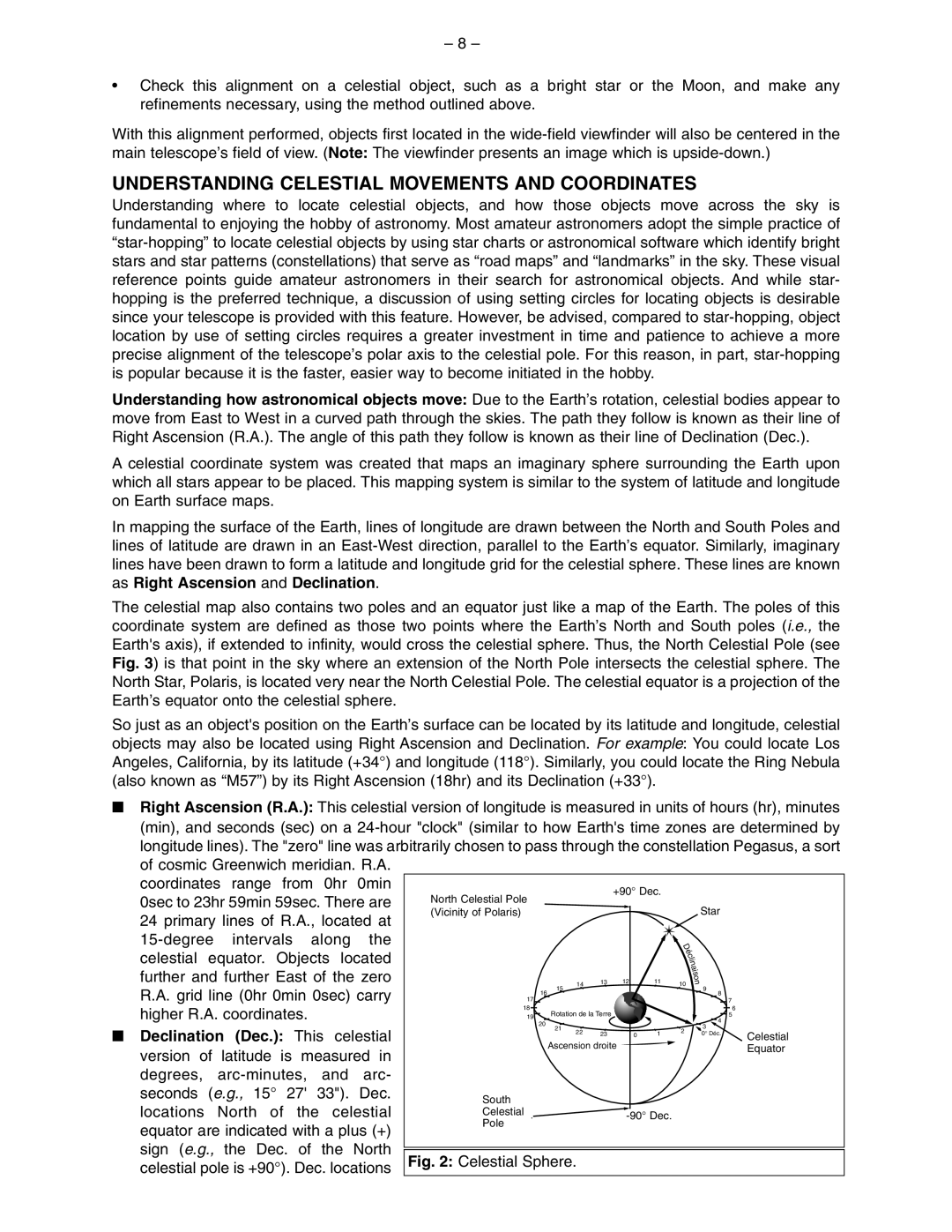
Understanding how astronomical objects move: Due to the Earth’s rotation, celestial bodies appear to move from East to West in a curved path through the skies. The path they follow is known as their line of Right Ascension (R.A.). The angle of this path they follow is known as their line of Declination (Dec.).
A celestial coordinate system was created that maps an imaginary sphere surrounding the Earth upon which all stars appear to be placed. This mapping system is similar to the system of latitude and longitude on Earth surface maps.
In mapping the surface of the Earth, lines of longitude are drawn between the North and South Poles and lines of latitude are drawn in an
The celestial map also contains two poles and an equator just like a map of the Earth. The poles of this coordinate system are defined as those two points where the Earth’s North and South poles (i.e., the Earth's axis), if extended to infinity, would cross the celestial sphere. Thus, the North Celestial Pole (see Fig. 3) is that point in the sky where an extension of the North Pole intersects the celestial sphere. The North Star, Polaris, is located very near the North Celestial Pole. The celestial equator is a projection of the Earth’s equator onto the celestial sphere.
So just as an object's position on the Earth’s surface can be located by its latitude and longitude, celestial objects may also be located using Right Ascension and Declination. For example: You could locate Los Angeles, California, by its latitude (+34°) and longitude (118°). Similarly, you could locate the Ring Nebula (also known as “M57”) by its Right Ascension (18hr) and its Declination (+33°).
■ Right Ascension (R.A.): This celestial version of longitude is measured in units of hours (hr), minutes (min), and seconds (sec) on a
of cosmic Greenwich meridian. R.A. |
|
|
|
|
|
|
|
|
|
|
|
|
|
|
|
|
|
|
|
|
|
|
|
|
|
|
| |||||||
coordinates | range from | 0hr | 0min |
|
|
|
|
|
|
|
|
|
|
|
|
|
|
|
|
|
|
|
|
|
|
|
|
|
|
| ||||
|
|
|
|
|
|
|
|
|
|
| +90° Dec. |
|
|
|
|
|
|
|
|
|
|
| ||||||||||||
|
|
|
|
|
|
|
|
|
|
|
|
|
|
|
|
|
|
|
|
|
|
|
|
|
|
|
|
| ||||||
0sec to 23hr 59min 59sec. There are |
| North Celestial Pole |
|
|
|
|
|
|
|
|
|
|
|
| ||||||||||||||||||||
|
|
|
|
|
|
|
|
|
|
|
|
|
|
|
|
|
|
|
|
| ||||||||||||||
|
| Pôle nord céleste |
|
|
|
|
|
|
|
|
|
|
|
|
|
|
|
|
|
|
|
| ||||||||||||
| (Vicinity of Polaris) |
|
|
|
|
|
|
|
|
|
|
|
|
| Star |
|
|
|
|
| ||||||||||||||
24 primary lines of R.A., located at |
|
|
|
|
|
|
|
|
|
|
|
|
|
|
|
|
|
|
| |||||||||||||||
|
|
|
|
|
|
|
|
|
|
|
|
|
|
|
|
|
|
|
|
|
|
|
|
|
|
| ||||||||
intervals | along | the |
|
|
|
|
|
|
|
|
|
|
|
|
|
|
|
|
|
| D |
|
|
|
|
|
|
| ||||||
celestial | equator. | Objects located |
|
|
|
|
|
|
|
|
|
|
|
|
|
|
|
|
|
| é |
|
|
|
|
|
|
| ||||||
|
|
|
|
|
|
|
|
|
|
|
|
|
|
|
|
|
|
| c |
|
|
|
|
|
|
| ||||||||
|
|
|
|
|
|
|
|
|
|
|
|
|
|
|
|
|
|
| l |
|
|
|
|
|
|
| ||||||||
|
|
|
|
|
|
|
|
|
|
|
|
|
|
|
|
|
|
| i |
|
|
|
|
|
|
| ||||||||
|
|
|
|
|
|
|
|
|
|
|
|
|
|
|
|
|
|
| n |
|
|
|
|
|
|
| ||||||||
further and further East of the zero |
|
|
|
|
|
|
|
|
|
|
|
|
|
|
|
|
|
|
| a |
|
|
|
|
|
|
| |||||||
|
|
|
|
|
|
|
|
|
|
|
|
|
|
|
|
|
|
| i |
|
|
|
|
|
|
| ||||||||
|
|
|
|
|
|
|
|
|
|
|
|
|
|
|
|
|
|
| s |
|
|
|
|
|
|
| ||||||||
|
|
|
|
|
|
|
|
|
| 13 |
| 12 |
| 11 |
|
|
| o |
|
|
|
|
|
|
| |||||||||
|
|
|
|
|
|
| 15 | 14 |
|
|
|
| 10 | n |
|
|
|
|
| |||||||||||||||
R.A. grid line (0hr 0min 0sec) carry |
|
|
|
|
|
|
|
|
|
|
|
|
|
|
|
| 9 |
|
|
|
|
|
| |||||||||||
|
|
|
|
|
|
|
|
|
|
|
|
|
|
|
|
|
|
|
|
|
|
|
| |||||||||||
17 | 16 |
|
|
|
|
|
|
|
|
|
|
| 8 |
|
|
|
|
| ||||||||||||||||
|
|
|
|
|
|
|
|
|
|
|
|
|
|
| 7 |
|
|
| ||||||||||||||||
higher R.A. coordinates. |
|
|
| 18 |
|
|
| Rotation de la Terre |
|
|
|
|
|
|
|
|
|
|
| 6 |
|
|
| |||||||||||
|
|
| 19 |
|
|
|
|
|
|
|
|
| 4 | 5 |
|
|
| |||||||||||||||||
|
|
|
|
|
|
|
|
|
|
|
|
|
|
|
|
|
|
|
|
| ||||||||||||||
|
|
|
|
|
|
|
|
|
| 20 |
|
|
|
|
|
|
|
|
|
|
|
|
|
|
|
| ||||||||
|
|
|
|
|
|
|
|
|
|
|
|
|
|
|
|
|
|
|
|
|
|
|
|
|
| 3 |
|
|
|
|
|
| ||
■ Declination | (Dec.): This | celestial |
|
|
|
|
|
|
| 21 | 22 23 |
|
|
|
|
|
|
| 2 |
|
|
|
|
|
|
| ||||||||
|
|
|
|
|
|
|
|
|
|
|
|
|
|
|
|
| 0° Déc. |
|
|
|
|
| ||||||||||||
|
|
|
|
|
|
|
|
|
|
|
| 0 | 1 |
|
|
|
|
| Celestial |
| ||||||||||||||
|
|
|
|
|
|
|
|
|
|
|
|
|
|
|
|
|
|
| ||||||||||||||||
version of latitude is measured in |
|
|
|
|
|
|
|
| Ascension droite |
|
|
|
|
|
|
|
|
|
|
|
| Equator |
| |||||||||||
|
|
|
|
|
|
|
|
|
|
|
|
|
|
|
|
|
|
|
|
|
|
|
|
|
|
| ||||||||
degrees, |
|
|
|
|
|
|
|
|
|
|
|
|
|
|
|
|
|
|
|
|
|
|
|
|
|
|
| |||||||
|
|
|
|
|
|
|
|
|
|
|
|
|
|
|
|
|
|
|
|
|
|
|
|
|
|
| ||||||||
seconds | (e.g., 15° | 27' | 33"). Dec. |
|
|
|
|
|
|
|
|
|
|
|
|
|
|
|
|
|
|
|
|
|
|
|
|
|
|
| ||||
|
|
|
| South |
|
|
|
|
|
|
|
|
|
|
|
|
|
|
|
|
|
|
|
|
| |||||||||
locations | North | of | the | celestial |
|
|
|
|
|
|
|
|
|
|
|
|
|
|
|
|
|
|
|
|
|
|
|
|
| |||||
|
|
|
| Celestial |
|
|
|
|
|
|
|
|
|
|
|
|
|
|
|
|
|
|
|
|
| |||||||||
| Pôle |
|
|
|
|
|
|
|
|
|
|
|
|
|
|
| ||||||||||||||||||
|
|
| céleste Sud. |
|
|
|
|
|
|
|
|
|
|
|
|
|
|
|
| |||||||||||||||
equator are indicated with a plus (+) |
|
|
|
| Pole |
|
|
|
|
|
|
|
|
|
|
|
|
|
|
|
|
|
|
|
|
| ||||||||
|
|
|
|
|
|
|
|
|
|
|
|
|
|
|
|
|
|
|
|
| ||||||||||||||
|
|
|
|
|
|
|
|
|
|
|
|
|
|
|
|
|
|
|
|
|
|
|
|
|
|
| ||||||||
|
|
|
|
|
|
|
|
|
|
|
|
|
|
|
|
|
|
|
|
|
|
|
|
|
|
| ||||||||
sign (e.g., the Dec. of the North |
|
|
|
|
|
|
|
|
|
|
|
|
|
|
|
|
|
|
|
|
|
|
|
|
|
|
| |||||||
|
|
|
|
|
|
|
|
|
|
|
|
|
|
|
|
|
|
|
|
|
|
|
|
|
|
| ||||||||
Fig. 2: Celestial Sphere. |
|
|
|
|
|
|
|
|
|
|
|
|
|
|
|
|
| |||||||||||||||||
celestial pole is +90°). Dec. locations |
|
|
|
|
|
|
|
|
|
|
|
|
|
|
|
|
| |||||||||||||||||