I450 Boost Mobile Phone User’s Guide
Contents
Entering Text
SMS
123
100
106
117
137
127
134
136
Page
Declaration of Conformity
Trick out your Phone
Introduction
Welcome to Boost Mobile
Boost Your Way
Getting Started
Idle screen in browser mode, returns to Web main menu
Getting Started
Battery
Removing the Battery Door
Inserting the Battery
Charging Times
Charging the Battery
Battery
Battery Charger
Removing the Battery
Battery Use and Maintenance
Inserting and Removing Your SIM
Inserting Your SIM Card
Removing Your SIM Card
Activating Service
Activating Service
Powering On and Off
When You Power On For the First Time
Browser Message Receive Programming Info, press a under Goto
Enabling Over-the-Air Security
Phone Basics
Customizing Features
Finding Your Phone Number BoostTM Walkie-Talkie
BoostTM Voice Mail
Menus and Lists
Quick Access to Main Menu Items
Text Area
Display Options
Main Menu
Status Icons
SIM Card Security
SIM Card Security
Entering Numbers From the Keypad
Turning the PIN Requirement On and Off
Entering the PIN
Changing the PIN
Unblocking the PIN
Locking the Keypad
Select Unblock PIN
Locking the Keypad
Antenna
Instant Re-BoostTMOption
Accessories
Accessories
Re-BoostTMOption
With the Flip Open
Making Calls
Phone Calls
BoostTM Walkie-Talkie Calls
Receiving Calls
Receiving Calls
Dialing BoostTM Walkie-Talkie Numbers
Phone Calls
Ending
Choosing a Number to Call
BoostTM Walkie-Talkie calls
Making Calls
Redialing the Last Number
Using a Voice Name
Using Speed Dial and Turbo Dial
Using One Touch BoostTM walkie-talkie
Making Emergency Phone Calls
Using Speakerphone
Using Mute
Missed Phone Calls
Making Emergency Phone Calls
Receiving Call Alerts
Using the Call Alert Queue
Call Alerts
Sending Call Alerts
Deleting Call Alerts
Viewing Call Alerts
Viewing Date and Time
Responding to Call Alerts in the Queue
Recent Calls
Calls and Call Alerts
My Info From Other Phones
Contact Information From Other Phones
Viewing the Recent Calls List
Contact Information From Other Phones
Recent Calls
Storing Items to Contacts
Deleting Items
Choosing Picture View or List View
Making Calls From the Recent Calls List
Select Delete All
Making Calls From the Recent Calls List
Recent Calls
Adding Words to the Database
Using Word Mode
Entering Text
Entering a Word
Capitalization
Special Function Keys
Choosing a Language
Spaces
Contacts
Accessing Contacts
Creating Entries
Contacts
Assigning a Ring Tone
Assigning a Speed Dial Number or Voice Name
Creating Entries
Selecting an Entry
Editing Entries
Viewing Entries
Viewing the Contacts List
Viewing More Details
Searching for a Name
Viewing Entries
Deleting Entries
Checking Capacity
Creating Pauses and Waits
International Numbers
International Numbers
Making Calls From Contacts
While Viewing the Contacts List
After Selecting an Entry
Select Store to Contacts
Memo
Forwarding Missed Calls
Call Forwarding
Forwarding All Calls
Turning Off Call Forwarding
Viewing Call Forwarding Settings
Viewing Call Forwarding Settings
Making International Calls
Advanced Calling Features
Putting a Call on Hold
Creating Pauses and Waits While Dialing
Turning Off One Touch BoostTM Walkie-Talkie
Setting Flip Actions
Setting One Touch BoostTM Walkie-Talkie WT
One Touch BoostTM Walkie-Talkie WT
Call Timers
Advanced Calling Features
For Ending Calls
Using Your Phone as a Modem
Using Your Phone as a Modem
Making TTY Calls
Calls TTY Use TTY. This field must say On
Turning On the TTY Feature
Choosing a Mode
Select In Call Setup TTY Type
Special Dialing Codes
Additional Phone Features
White Page Listings
Per-Call Blocking
Per-Line Blocking
BoostTM
Local Event Information
Additional Phone Features
Restaurant Reservations
Movie Listings and Show Times
Setting Notification Options
Messages
Message Notifications
Sending a Text Message
Voice Mail
Boost Mobile Text and Numeric Messages
Sending Unanswered Calls to Voice Mail
Web Messaging on BoostMobile.com
Sending a Numeric Message
Receiving a Message
Messages
Web Alerts
Web Alerts
Reading from the Message Center
Deleting Web Alerts
Ringtones
Setting Your Phone to Vibrate
Assigning Ringtones to Contacts
Assigning Ringtones to Contacts
Ring and Vibrate
Viewing Ringtone Assignments
Select Memory Usage
Downloading More Ringtones Managing Memory
Deleting Custom Ringtones
Ringtones
Multi-Media Messages
Navigating the Inbox, Drafts, and Sent Items
Creating and Sending Messages
Creating a Message
Sending or Canceling
Entering Text
Message Size
Creating and Sending Messages
Adding More Message Options
Select Valid Until
Replying to a Message
From Contacts
More Ways to Begin a Message
From My Pictures
More Ways to Address a Message
From the Recent Calls List
From the Idle Screen
Select Recent Calls
Quick Notes
Inserting Pictures, Ring Tones, and Voice Records
Attaching Pictures, Ring Tones, and Voice Records
Select New Attachment Select My Pictures
Select New Attachment Select Ring Tones
Editing a Draft
Drafts
Saving a Message in Drafts
Sending a Draft
Sent Items
Embedded Objects and Attachments
Receiving a Message
Navigating a Message
Sent Items Icons
Viewing Received Messages from the Message Center
Viewing Received Messages from the Message Center
Opening Attachments
Inbox Icons
Locking and Unlocking
Actions for Received Messages
Replying
Forwarding
Storing Message Information To Contacts
Going to a Website
Actions for Received Messages
Deleting Attachments
Saving an Embedded Picture or Voice Record
Deleting an Embedded Picture, Ring Tone, or Voice Record
Saving Attachments
Customizing MMS
New Quick Notes and Reply Phrases
Customizing MMS
Setting the Clean-up Option
Clean-up Options
For the Inbox
Managing Memory
Select Setup Memory Size
For Sent Items
Choosing to Delete Messages Later
Scroll to Inbox, Draft, or Sent Items
Deleting All Messages
Setting Up Your Voice Mail Box
Boost Mobile Voice Mail
Playing Messages
Boost Mobile Voice Mail
Changing Your Password
Recording Your Name
Recording Your Active Greeting
Advanced Voice Mail Features
Advanced Voice Mail Features
Multiple Greetings
Automatic Playback
Greetings Schedule
Changing the Playback Order of Messages
Recording, Forwarding, and Replying to Messages
Delivery Options
Working With Group Lists
Message Forwarding
Calling and Storing Numbers
SMS Messages
Number
SMS Messages
Starting the Microbrowser
BoostTM Wireless Web Services
Starting the Microbrowser
BoostTM Wireless Web Navigation Keys
Deleting Pictures
My Pictures
Viewing Pictures
Getting File Information
My Info
Viewing My Info
Editing My Info
My Info
Setting Sending Options
Information Sent
Automatic Sending
Sending Contact Information
Using Walkie-Talkie Send
Sending My Info and Contact Information
Sending My Info
Select WT Send Contact
Using Walkie-Talkie Send
Receiving My Info or Contact Information
Select Contacts or Recent Calls
Voice Records
Viewing Voice Records
Creating Voice Records
Phone in a Call
Playing Voice Records
Labeling Voice Records
Locking Voice Records
Deleting Voice Records
Deleting Voice Records
Deleting a Voice Record
Deleting All Voice Records
Resuming Applications
Java Applications
Running Applications
Suspending Applications
Scroll to Suspended Apps
Installing Applications
Ending Applications
Downloading Applications
Java Applications
Select Deinstall
Deleting Applications
About DRM Java Applications
Personalize Menu Options Add/Remove Apps. -or
Java Applications and GPS Enabled
Setting Privacy for All Java Applications
Shortcuts on the Main Menu
Granting or Denying Permission
Setting Privacy for Each Java Application
Java Applications and GPS Enabled
Select Permissions
Renewing DRM Licenses
Digital Rights Management DRM
Managing Items
Viewing License Information
Deleting Items
About Expired Items
Managing Items
GPS Global Positioning System Enabled
Important Things to Keep in Mind
Mind
Making an Emergency Call
Making an Emergency Call
Viewing Your Approximate Location
GPS Global Positioning System Enabled
Enhancing GPS Performance
Enhancing GPS Performance
112
Setting Privacy Options
Updating Satellite Almanac Data
Updating Satellite Almanac Data
Setting the GPS PIN Security Feature
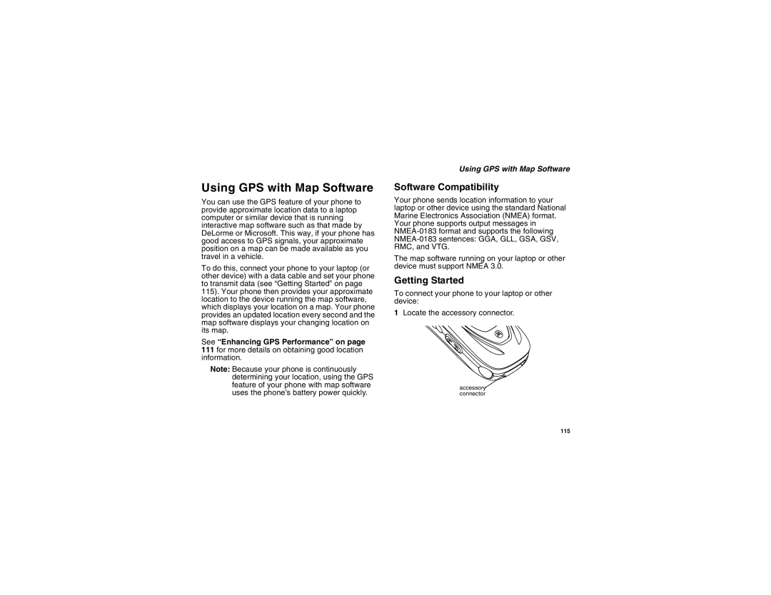
Getting Started
Using GPS with Map Software
Using GPS with Map Software
Software Compatibility
Set Nmea OUT to Off
Set Nmea OUT to On
Viewing Datebook
Datebook
Select Go To Today
Creating Events
Navigating Datebook
Datebook
Creating Events
Select Ring Tone
Editing Events
Deleting Events
Assigning More Options
For Events with Numbers to Call
Receiving Reminders
Making Calls From Datebook
For Events with Java Applications
Customizing Datebook Setup
Viewing Profiles
Switching Profiles
How Changing Settings Affects Profiles
Profiles
Profiles
Select Setup Temp Profile
Temporary Profiles
Storing a Temporary Profile
Creating Profiles
Creating Profiles
Editing Profiles
Deleting Profiles
Setting Call Filtering
Wallpaper
Setting the Volume
Customizing Your Phone
Changing the Look of Your Phone
Setting the Backlight
Setting Text Size
Setting Contrast
Setting the Menu View
Airplane Mode-Temporarily Turning Off Calls
Using Settings
Settings Display/Info Backlight Java Timer
Airplane Mode-Temporarily Turning Off Calls
Phone Calls Features
Display/Info Features
Using Settings
Walkie-Talkie Options Features
Personalize Features
Volume Features
Advanced Features
Security Features
133
Using a Shortcut
Shortcuts
Creating a Shortcut
Editing a Shortcut
Deleting Shortcuts
Editing a Shortcut
Using a Headset
Using a Remote BoostTM Walkie-Talkie Button
Attaching a Headset
BoostTM Customer Care
Understanding Status Messages
Status
Messages One-line Full-screen Display
SIM PIN
Understanding Status Messages
Technical Error
Boost Mobile Terms and Conditions of Service
Boost Mobile Terms and Conditions of Service
143
Boost Mobile Wireless WEB Services
145
146
147
148
149
150
Safety and General Information
RF Operational Characteristics
Portable Radio Product Operation and EME Exposure
Body-worn operation
Safety and General Information
Phone Operation
Two-way radio operation
Approved Accessories
Antenna Care
Portable Radio Product Operation and EME Exposure
Electro Magnetic Interference/Compatibility
Facilities
Aircraft
Other Medical Devices
Medical Devices
Pacemakers
Hearing Aids
Operational Cautions
Operational Warnings
Accessory Safety Information
Cleaning and Drying Considerations
Accessory Safety Information
158
Hearing Aid Compatibility
Above Date of purchase by
What Does this Warranty Cover?
Products or Balance Accessories that are
Product
What is not covered? Exclusions
TTY-877-483-2840
Motorola Limited Warranty
163
Patent and Trademark Information
Index
Index
Email 37, 49 messaging 56 receiving 57 sending
168
MMS messages attachments 72, 73, 76 calls from 74 creating
170
171
172
173
174