Raymarine Marine RADAR manual Basic Navigation, Working with Waypoints

Models: Marine RADAR

1 26
Download 26 pages 20.47 Kb
Page 12
Image 12

Basic Navigation

Working with Waypoints

Card 11

WAYPOINT AT

WAYPOINT AT

WAYPOINT AT

GO TO WAYPOINT

REVIEW AND EDIT

CURSOR

VESSEL

LAT/LON

OPTIONS

WAYPOINTS


What is a waypoint?

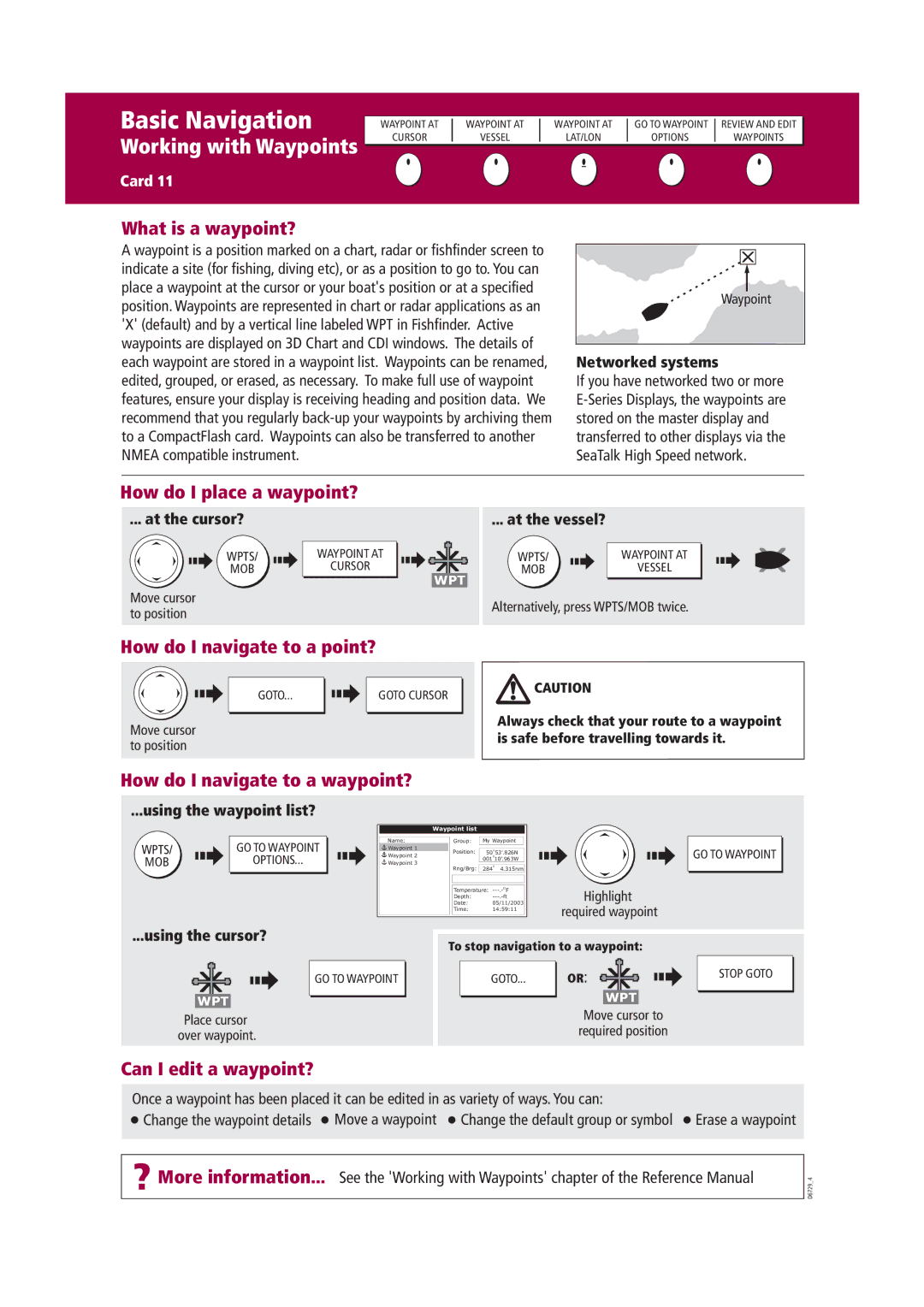
A waypoint is a position marked on a chart, radar or fishfinder screen to indicate a site (for fishing, diving etc), or as a position to go to. You can place a waypoint at the cursor or your boat's position or at a specified position. Waypoints are represented in chart or radar applications as an 'X' (default) and by a vertical line labeled WPT in Fishfinder. Active waypoints are displayed on 3D Chart and CDI windows. The details of each waypoint are stored in a waypoint list. Waypoints can be renamed, edited, grouped, or erased, as necessary. To make full use of waypoint features, ensure your display is receiving heading and position data. We recommend that you regularly back-up your waypoints by archiving them to a CompactFlash card. Waypoints can also be transferred to another NMEA compatible instrument.

Waypoint

Networked systems

If you have networked two or more E-Series Displays, the waypoints are stored on the master display and transferred to other displays via the SeaTalk High Speed network.

How do I place a waypoint?

... at the cursor?

... at the vessel?

WPTS/

WAYPOINT AT

WPTS/

WAYPOINT AT

MOB

CURSOR

MOB

VESSEL

WPT

Move cursor

Alternatively, press WPTS/MOB twice.

to position


How do I navigate to a point?

GOTO...


GOTO CURSOR


Move cursor to position

CAUTION

Always check that your route to a waypoint is safe before travelling towards it.

How do I navigate to a waypoint?

...using the waypoint list?

Waypoint list

WPTS/

GO TO WAYPOINT

Name:

Group:

My Waypoint

Waypoint 1

Position:

o

53’.826N

Waypoint 2

OPTIONS...


50o

MOB

Waypoint 3


001 10’.963W

Rng/Brg:

284o

4.315nm


Temperature: ---.-OF

Highlight

Date:

05/11/2003

Depth:

---.-ft

required waypoint

Time:

14:59:11


GO TO WAYPOINT

...using the cursor?

GO TO WAYPOINT

WPT

Place cursor over waypoint.

To stop navigation to a waypoint:

GOTO

OR:


WPT


Move cursor to


required position

STOP GOTO

Can I edit a waypoint?

Once a waypoint has been placed it can be edited in as variety of ways. You can:

Change the waypoint details Move a waypoint Change the default group or symbol Erase a waypoint

? More information... See the 'Working with Waypoints' chapter of the Reference Manual

D6729_4

Page 12
Image 12
Raymarine Marine RADAR manual Basic Navigation, Working with Waypoints

Marine RADAR specifications

Raymarine Marine RADAR systems are essential tools for navigating the high seas, providing boaters with unparalleled situational awareness and safety. Designed for both recreational and commercial vessels, Raymarine RADAR technology integrates advanced features and functionalities that enhance maritime experiences.

One of the standout characteristics of Raymarine RADAR is its high-definition imaging capabilities. Utilizing both pulse compression and digital signal processing, these systems can distinguish between various targets, such as buoys, other vessels, and land obstacles. The improved resolution helps users to identify potential hazards and navigate more safely.

Raymarine offers a variety of RADAR models, including the Quantum and HD Series. The Quantum RADAR employs a revolutionary solid-state design that delivers exceptional performance while consuming less power. This is particularly beneficial for smaller vessels or those seeking to minimize energy consumption. The Quantum antenna features Doppler technology, which enhances motion detection and allows for real-time tracking of moving targets, providing critical information on their speed and direction.

Another key feature of Raymarine RADAR systems is their integration with other onboard navigation systems. With access to Raymarine’s LightHouse user interface, the RADAR seamlessly connects with chartplotters, autopilots, and other sensors. This complete network enhances situational awareness, as users can overlay RADAR data on navigational charts for a comprehensive view of their surroundings.

Raymarine also prioritizes user-friendly operability. The systems come equipped with intuitive controls and customizable displays, allowing users to adjust settings quickly and effortlessly, ensuring optimal performance in varying environmental conditions. These RADAR systems can automatically calibrate to changing conditions, such as rain or fog, to maintain clear visibility.

Safety and reliability are paramount in marine navigation, and Raymarine RADAR systems provide robust weather-resistant features. Their rugged construction ensures they can withstand harsh marine environments, while advanced noise reduction technology ensures clarity even in choppy waters.

Finally, Raymarine's commitment to innovation ensures that their RADAR systems are always ahead of the curve. With regular software updates and advancements in technology, boaters can trust that their equipment will remain cutting-edge throughout its lifespan. In summary, Raymarine Marine RADAR systems exemplify the perfect blend of technology, performance, and user-friendliness, making them essential tools for anyone venturing out on the water.