
PLB-350B, 2883, 2882 specifications
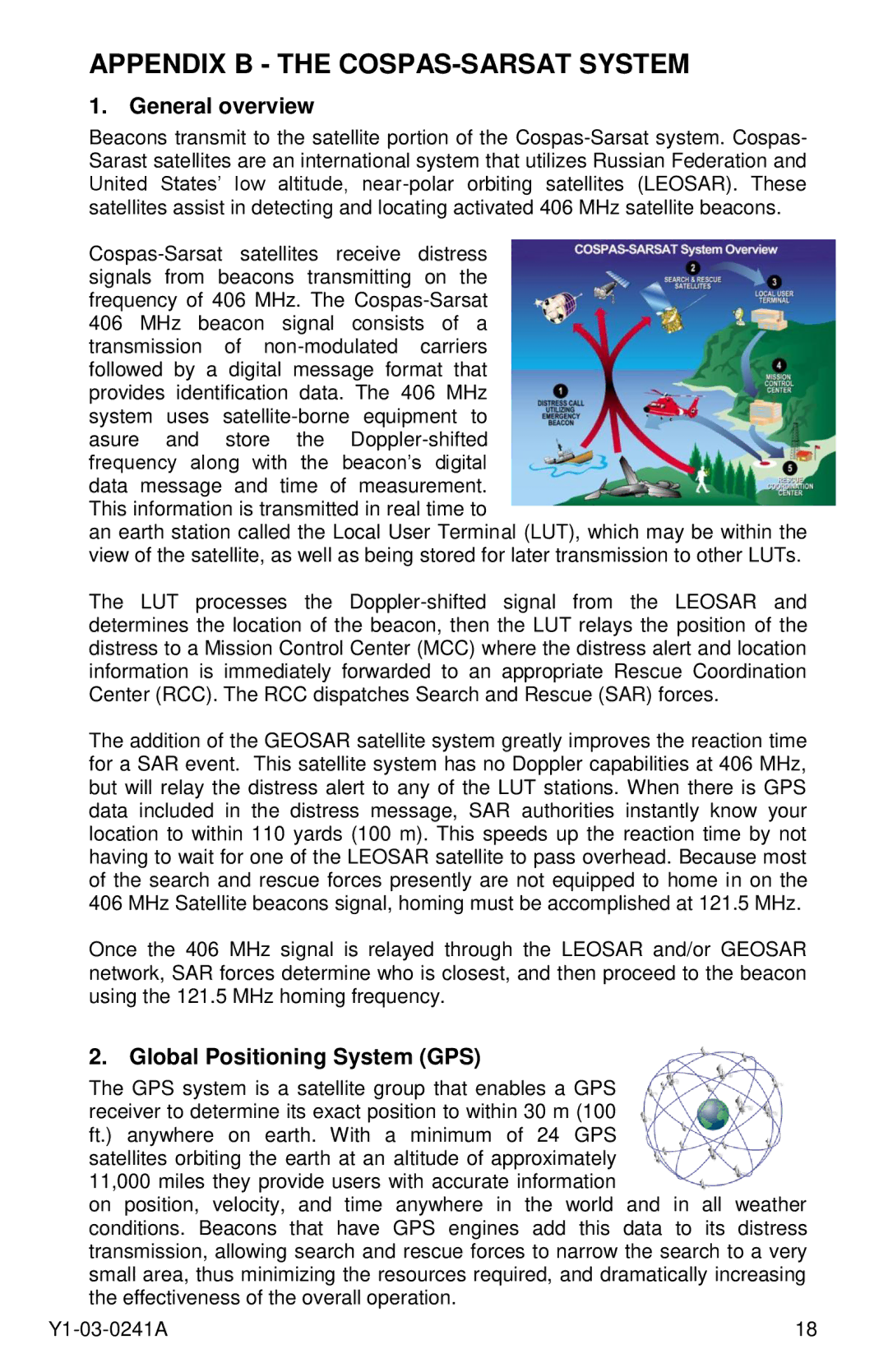
ACR Electronics is a renowned name in the field of emergency signaling and safety devices. Among its various offerings, the ACR 2882, ACR 2883, and the PLB-350B Personal Locator Beacons (PLBs) stand out due to their advanced features and reliability.The ACR 2882 and 2883 models are compact and rugged PLBs designed for outdoor enthusiasts, sailors, and adventurers who venture into remote areas. One of their main features is the dual frequency capability, which operates on both 406 MHz and 121.5 MHz frequencies. This dual-frequency technology enhances their effectiveness in emergency situations, ensuring that distress signals can be received by both satellite systems and local search and rescue teams.
Both models are equipped with a high-performance GPS receiver, which significantly improves location accuracy. In challenging environments, where precise positioning is crucial, these PLBs can obtain a location fix quickly and share it with rescue services. The compact design, weighing around 7 ounces, makes them portable enough to carry on any adventure without adding significant weight to your gear.
Battery life is another critical feature of the ACR 2882 and ACR 2883. They utilize a lithium battery that can provide up to 24 hours of continuous operation upon activation. This extended battery life ensures that users have a dependable signal even in prolonged emergencies, and they can be easily tested and replaced when needed.
On the other hand, the PLB-350B stands out with its innovative design and user-friendly interface. It features an intuitive one-button activation system that allows users to signal for help swiftly. Its rugged construction is built to withstand harsh conditions, making it suitable for a variety of outdoor activities like hiking, fishing, or boating.
Additionally, the PLB-350B includes a built-in strobe light, which serves as a visual distress signal, further increasing the chances of rescue. Its battery is designed to last for up to 7 years, offering a reliable solution for safety without frequent maintenance requirements.
Collectively, the ACR 2882, 2883, and PLB-350B represent the cutting edge of personal safety technology. With their advanced communication capabilities, durable design, and user-friendly features, these devices are essential tools for anyone who values safety during outdoor adventures. They provide peace of mind knowing that help is just a button press away, no matter where you find yourself.