Furuno 1954C specifications MaxSea-NavNet PC software, Interface with the NavNet system

Models: 1954C

1 10
Download 10 pages 42.92 Kb
Page 7
Image 7

MaxSea-NavNet PC software

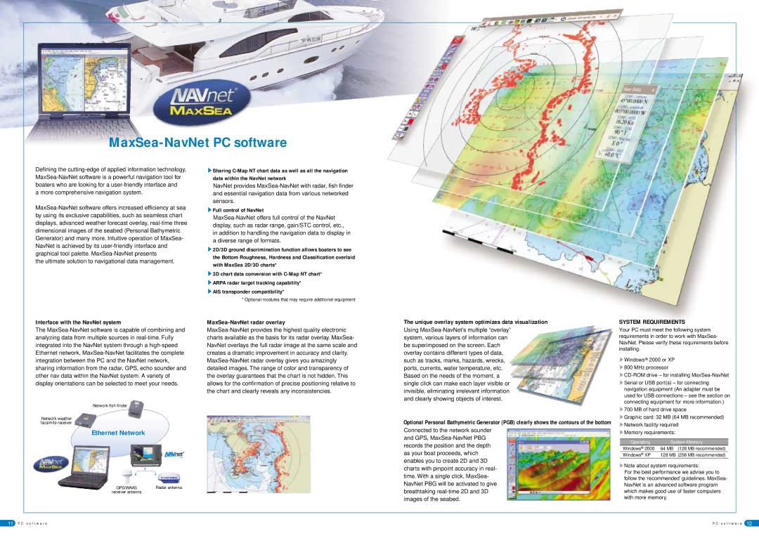
Defining the cutting-edge of applied information technology, MaxSea-NavNet software is a powerful navigation tool for boaters who are looking for a user-friendly interface and

a more comprehensive navigation system.

MaxSea-NavNet software offers increased efficiency at sea by using its exclusive capabilities, such as seamless chart displays, advanced weather forecast overlay, real-time three dimensional images of the seabed (Personal Bathymetric Generator) and many more. Intuitive operation of MaxSea- NavNet is achieved by its user-friendly interface and graphical tool palette. MaxSea-NavNet presents

the ultimate solution to navigational data management.

sSharing C-Map NT chart data as well as all the navigation data within the NavNet network

NavNet provides MaxSea-NavNet with radar, fish finder and essential navigation data from various networked sensors.

sFull control of NavNet

MaxSea-NavNet offers full control of the NavNet display, such as radar range, gain/STC control, etc., in addition to handling the navigation data to display in a diverse range of formats.

s2D/3D ground discrimination function allows boaters to see the Bottom Roughness, Hardness and Classification overlaid with MaxSea 2D/3D charts*

s3D chart data conversion with C-Map NT chart* sARPA radar target tracking capability*

sAIS transponder compatibility*

* Optional modules that may require additional equipment

Interface with the NavNet system

The MaxSea-NavNet software is capable of combining and analyzing data from multiple sources in real-time. Fully integrated into the NavNet system through a high-speed Ethernet network, MaxSea-NavNet facilitates the complete integration between the PC and the NavNet network, sharing information from the radar, GPS, echo sounder and other nav data within the NavNet system. A variety of display orientations can be selected to meet your needs.

Network fish finder

Network weather facsimile receiver

Ethernet Network

MaxSea-NavNet radar overlay

MaxSea-NavNet provides the highest quality electronic charts available as the basis for its radar overlay. MaxSea- NavNet overlays the full radar image at the same scale and creates a dramatic improvement in accuracy and clarity. MaxSea-NavNet radar overlay gives you amazingly detailed images. The range of color and transparency of the overlay guarantees that the chart is not hidden. This allows for the confirmation of precise positioning relative to the chart and clearly reveals any inconsistencies.

The unique overlay system optimizes data visualization

Using MaxSea-NavNet's multiple“overlay” system, various layers of information can be superimposed on the screen. Each overlay contains different types of data, such as tracks, marks, hazards, wrecks, ports, currents, water temperature, etc. Based on the needs of the moment, a single click can make each layer visible or invisible, eliminating irrelevant information and clearly showing objects of interest.

Optional Personal Bathymetric Generator (PGB) clearly shows the contours of the bottom

Connected to the network sounder and GPS, MaxSea-NavNet PBG records the position and the depth as your boat proceeds, which enables you to create 2D and 3D charts with pinpoint accuracy in real-

SYSTEM REQUIREMENTS

Your PC must meet the following system requirements in order to work with MaxSea- NavNet. Please verify these requirements before installing.

sWindows® 2000 or XP s800 MHz processor

sCD-ROM drive – for installing MaxSea-NavNet sSerial or USB port(s) – for connecting

navigation equipment (An adapter must be used for USB connections – see the section on connecting equipment for more information.)

s700 MB of hard drive space

sGraphic card: 32 MB (64 MB recommended) sNetwork facility required

sMemory requirements:

Operating

System Memory

Windows® 2000

64 MB (128 MB recommended)

Windows® XP

128 MB (256 MB recommended)

sNote about system requirements:

GPS/WAAS

Radar antenna

receiver antenna


time. With a single click, MaxSea- NavNet PBG will be activated to give breathtaking real-time 2D and 3D images of the seabed.

For the best performance we advise you to follow the ‘recommended’ guidelines. MaxSea- NavNet is an advanced software program which makes good use of faster computers with more memory.

11 P C s o f t w a r e

P C s o f t w a r e 12

Page 7
Image 7
Furuno 1954C specifications MaxSea-NavNet PC software, Interface with the NavNet system, MaxSea-NavNet radar overlay

1954C specifications

Furuno is renowned in the marine electronics industry for producing high-quality navigation equipment, particularly its range of radars. Among its flagship models, the Furuno 1944C, 1964C, 1834C, 1954C, and 1934C stand out due to their advanced features, robust technology, and reliability, making them essential tools for both commercial and recreational vessels.

The Furuno 1944C is a 12-inch color radar that boasts a powerful 4 kW output. This model integrates a user-friendly interface that enhances operational convenience, providing mariners with critical navigation information at their fingertips. With features such as advanced target detection and tracking, it helps to identify vessels and obstacles efficiently, which is vital for safe navigation.

Next, the 1964C takes functionality further with its larger 19-inch display and enhanced signal processing capabilities. The 1964C not only provides an impressive range but also features ARPA (Automatic Radar Plotting Aid) for tracking multiple targets. This functionality allows boat operators to assess risk levels and make informed decisions regarding navigation in busy waterway environments.

The Furuno 1834C is another notable entry in the series, maximizing real-time data display. Its ability to work seamlessly with Furuno's Navigator and Fish Finder systems means it doubles in utility for those who require both navigation and fishing capabilities. The intuitive interface makes it easy to access essential information, ensuring that users can maintain their focus on the sea.

The 1954C radar system incorporates some of the most advanced radar technology, providing detailed target information and exceptional clarity through its color display. Its 4 kW output delivers long-range detection, making it a suitable choice for larger vessels operating in various maritime conditions.

Lastly, the Furuno 1934C rounds out this impressive lineup with its compact design, tailored for smaller boats without sacrificing performance. Its solid 4 kW radar provides excellent target separation and enhanced echo clarity. In addition, it is compatible with a variety of additional sensors, allowing operators to expand their situational awareness.

All these models share common features including a weatherproof design, multiple display modes, and customizable settings, ensuring they cater to a diverse range of maritime applications. With Furuno's continuous innovation and commitment to quality, these radar systems embody the brand's legacy in safety and performance at sea.