What’s On the Sonar Display
The 700 Series™ can display a variety of useful information about the area under and adjacent to your
boat, including the following items:
Depth - water depth; can be set to alarm when the water becomes too shallow.
Speed - if a Temp/Speed accessory or GPS Receiver is attached, the 700 Series™ can display the speed of the boat, and can keep a Triplog of nautical or statute miles traveled.
Temperature - water surface temperature.
Cursor - available in Freeze Frame and can be sonar return and bottom depth below the cursor.
positioned in the Sonar View to provide depth of a
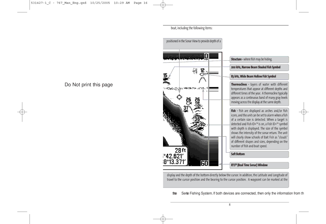
Structure - where fish may be hiding.
200 kHz, Narrow Beam Shaded Fish Symbol
![]() 83 kHz, Wide Beam Hollow Fish Symbol
83 kHz, Wide Beam Hollow Fish Symbol
Do Not print this page
Timer - elapsed time with Temp/Speed
Distance - distance
traveled with
Average Speed -
Thermoclines - layers of water with different temperatures that appear at different depths and different times of the year. A thermocline typically appears as a continuous band of many gray levels moving across the display at the same depth.
Fish - fish are displayed as arches and/or fish icons, and the unit can be set to alarm when a fish
average speed reading
Bait Ball
Hard Bottom
Rocky Bottom
Second Sonar Return - when the sonar signal bounces between the bottom and the surface of the water and back again. Use the appearance of the second return to determine bottom hardness. Hard bottoms will show a strong second return, while soft bottoms will show a very weak one or none at all.
Cursor Dialog Box - indicates cursor depth on the the cursor position is shown, the distance to cursor position for later retrieval and use.
of a certain size is detected. When a target is ![]() detected and Fish ID+TM is on, a Fish ID+TM symbol with depth is displayed. The size of the symbol shows the intensity of the sonar return. The unit will clearly show schools of Bait Fish as "clouds" of different shapes and sizes, depending on the
detected and Fish ID+TM is on, a Fish ID+TM symbol with depth is displayed. The size of the symbol shows the intensity of the sonar return. The unit will clearly show schools of Bait Fish as "clouds" of different shapes and sizes, depending on the
number of fish and boat speed.
Soft Bottom
![]() RTS® (Real Time Sonar) Window
RTS® (Real Time Sonar) Window
display and the depth of the bottom directly below the cursor. In addition, the Latitude and Longitude of travel to the cursor position and the bearing to the cursor position. A waypoint can be marked at the
NOTE: Entries in this view that list (with Temp/Speed or GPS Receiver) are available if either device is connected receiver will be displayed on the view.
to the 700 Series™ Fishing System. If both devices are connected, then only the information from the GPS
4 | 8 |
