Satellite Locator Chart
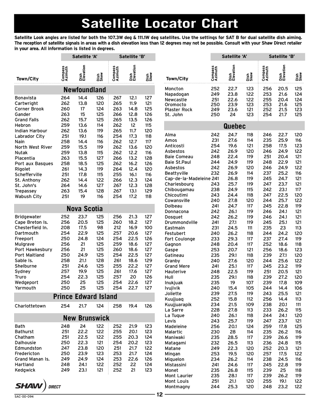
Satellite Look angles are listed for both the 107.3W deg & 111.1W deg satellites. Use the settings for SAT B for dual satellite dish aiming. The reception of satellitesignals in areas with adish elevation less than 12 degreesmay not be possible. Consult withyourShaw Direct retailer in your area. All information is listed in degrees.
|
|
| Satellite ‘A’ | Satellite ‘B’ |
| |||
Town/City |
| Compass Azimuth | Dish Elevation | Dish Skew | Compass Azimuth | Dish Elevation | Dish Skew |
|
|
|
|
|
|
|
| ||
|
| Newfoundland |
|
|
|
| ||
Bonavista | 264 | 14.4 | 126 | 267 | 12.1 | 127 |
| |
Cartwright | 262 | 13.8 | 120 | 265 | 11.9 | 121 |
| |
Corner Brook | 260 | 17 | 124 | 263 | 14.8 | 125 |
| |
Gander | 263 | 15 | 125 | 266 | 12.8 | 126 |
| |
Grand Falls | 262 | 15.7 | 125 | 265 | 13.5 | 126 |
| |
Hebron | 259 | 13.6 | 114 | 262 | 12 | 115 |
| |
Indian Harbour | 262 | 13.6 | 119 | 265 | 11.7 | 120 |
| |
Labrador City | 251 | 19.1 | 116 | 254 | 17.3 | 118 |
| |
Nain | 258 | 14.4 | 116 | 262 | 12.7 | 117 |
| |
North West River | 259 | 15.5 | 119 | 262 | 13.6 | 120 |
| |
Nutak | 259 | 13.8 | 115 | 262 | 12.2 | 116 |
| |
Placentia | 263 | 15.5 | 127 | 266 | 13.2 | 128 |
| |
Port aux Basques | 258 | 18.5 | 125 | 262 | 16.2 | 126 |
| |
Rigolet | 261 | 14.3 | 119 | 264 | 12.4 | 120 |
| |
Schefferville | 251 | 17.8 | 115 | 255 | 16.1 | 116 |
| |
St. Anthony | 262 | 14.4 | 122 | 266 | 12.3 | 124 |
| |
St. John's | 264 | 14.6 | 127 | 267 | 12.3 | 128 |
| |
Trepassey | 263 | 15.4 | 128 | 267 | 13.1 | 129 |
| |
Wabush City | 251 | 19 | 116 | 254 | 17.2 | 118 |
| |
|
|
|
|
|
|
| ||
|
| Nova Scotia |
|
|
|
| ||
Bridgewater | 252 | 23.7 | 125 | 256 | 21.3 | 127 |
| |
Cape Breton Is. | 256 | 20.5 | 125 | 260 | 18.2 | 127 |
| |
Chesterfield In. | 208 | 17.5 | 98 | 212 | 16.9 | 100 |
| |
Dartmouth | 254 | 22.9 | 125 | 257 | 20.6 | 127 |
| |
Freeport | 250 | 24.8 | 124 | 254 | 22.5 | 126 |
| |
Mulgrave | 256 | 21 | 125 | 259 | 18.6 | 127 |
| |
Port Hawkesbury | 256 | 21 | 125 | 260 | 18.6 | 127 |
| |
Port Maitland | 250 | 24.9 | 125 | 254 | 22.5 | 127 |
| |
Sable Is. | 258 | 21.1 | 128 | 261 | 18.6 | 129 |
| |
Shelburne | 251 | 24.6 | 125 | 255 | 22.2 | 127 |
| |
Sydney | 257 | 19.9 | 125 | 261 | 17.6 | 127 |
| |
Truro | 254 | 22.3 | 125 | 257 | 20 | 126 |
| |
Wedgeport | 250 | 25 | 125 | 254 | 22.6 | 127 |
| |
Yarmouth | 250 | 25 | 125 | 254 | 22.7 | 127 |
| |
|
|
|
|
|
| |||
| Prince Edward Island |
|
|
| ||||
Charlottetown | 254 | 21.7 | 124 | 258 | 19.4 | 126 |
| |
|
|
|
|
|
|
| ||
|
| New Brunswick |
|
|
|
| ||
Bath | 248 | 24 | 122 | 252 | 21.9 | 123 |
| |
Bathurst | 251 | 22.2 | 122 | 255 | 20.1 | 123 |
| |
Chatham | 251 | 22.5 | 122 | 255 | 20.3 | 124 |
| |
Dalhousie | 250 | 22.3 | 121 | 254 | 20.2 | 123 |
| |
Edmundston | 247 | 23.8 | 120 | 251 | 21.7 | 122 |
| |
Fredericton | 250 | 23.9 | 123 | 253 | 21.7 | 124 |
| |
Grand Manan Is. | 249 | 24.9 | 124 | 253 | 22.6 | 126 |
| |
Hartland | 248 | 24.1 | 122 | 252 | 22 | 124 |
| |
Kedgwick | 249 | 23.1 | 121 | 252 | 21 | 123 |
| |
Satellite ‘A’
Town/City | Compass Azimuth | Dish Elevation | Dish Skew |
Moncton | 252 | 22.7 | 123 |
Napadogan | 249 | 23.8 | 122 |
Newcastle | 251 | 22.6 | 122 |
Oromocto | 250 | 23.9 | 123 |
Plaster Rock | 249 | 23.6 | 121 |
St. John | 250 | 24 | 123 |
Quebec
Alma | 242 | 24.7 | 118 |
Amos | 231 | 27.6 | 114 |
Anticosti | 254 | 19.6 | 121 |
Asbestos | 242 | 26.9 | 120 |
Baie Comeau | 248 | 22.4 | 119 |
Baie St.Paul | 244 | 24.9 | 119 |
Asbestos | 242 | 26.9 | 120 |
Beattyville | 232 | 26.9 | 114 |
26.8 | 119 | ||
Charlesbourg | 243 | 25.7 | 119 |
Chibougamau | 238 | 24.9 | 115 |
Chicoutimi | 243 | 24.4 | 118 |
Cowansville | 240 | 27.8 | 120 |
Dolbeau | 241 | 24.7 | 117 |
Donnacona | 242 | 26.1 | 119 |
Dosquet | 242 | 26.2 | 119 |
Drummondville | 241 | 27.1 | 119 |
Eastmain | 231 | 24.5 | 111 |
Festubert | 240 | 26.2 | 118 |
Fort Coulonge | 233 | 29.3 | 117 |
Gagnon | 248 | 20.4 | 117 |
Gaspe | 253 | 20.7 | 121 |
Gatineau | 235 | 29.1 | 118 |
Granby | 240 | 27.6 | 120 |
Grand Mere | 241 | 25.1 | 117 |
Hauterive | 248 | 22.5 | 119 |
Hull | 235 | 29.1 | 118 |
Inukjuak | 235 | 19 | 107 |
Ivujivik | 240 | 15.4 | 105 |
Joliette | 239 | 27.5 | 119 |
Kuujjuaq | 252 | 15.8 | 112 |
Kuujjuarapik | 234 | 21.5 | 109 |
La Sarre | 228 | 27.8 | 113 |
La Tuque | 240 | 26.1 | 118 |
Levis | 243 | 25.7 | 119 |
Madeleine | 256 | 20.1 | 124 |
Malartic | 230 | 28 | 114 |
Maniwaki | 235 | 28.5 | 117 |
Matagami | 232 | 26.5 | 113 |
Matane | 249 | 22.3 | 120 |
Mingan | 253 | 19.5 | 120 |
Miquelon | 234 | 26.2 | 114 |
Mistassini | 241 | 24.6 | 117 |
Monet | 235 | 26.8 | 115 |
Mont Laurier | 235 | 28.1 | 117 |
Mont Louis | 251 | 21.1 | 120 |
Montmagny | 244 | 25.3 | 120 |
Satellite ‘B’
Compass Azimuth | Dish Elevation | Dish Skew |
256 | 20.5 | 125 |
253 | 21.6 | 124 |
255 | 20.4 | 124 |
253 | 21.6 | 125 |
252 | 21.5 | 123 |
254 | 21.7 | 125 |
246 | 22.7 | 120 |
235 | 25.9 | 116 |
258 | 17.5 | 123 |
246 | 24.9 | 122 |
251 | 20.4 | 121 |
248 | 22.9 | 121 |
246 | 24.9 | 122 |
237 | 25.2 | 116 |
245 | 24.7 | 121 |
247 | 23.7 | 121 |
242 | 23.1 | 117 |
247 | 22.5 | 120 |
244 | 25.7 | 122 |
245 | 22.8 | 119 |
246 | 24.1 | 121 |
246 | 24.1 | 121 |
245 | 25.1 | 121 |
235 | 23 | 113 |
244 | 24.2 | 120 |
237 | 27.4 | 119 |
252 | 18.6 | 118 |
256 | 18.6 | 123 |
239 | 27.1 | 120 |
244 | 25.6 | 122 |
245 | 23.2 | 119 |
251 | 20.5 | 121 |
239 | 27.2 | 120 |
239 | 17.8 | 109 |
244 | 14.4 | 106 |
243 | 25.5 | 121 |
256 | 14.4 | 113 |
238 | 20.1 | 111 |
233 | 26.2 | 115 |
244 | 24.1 | 120 |
247 | 23.7 | 121 |
259 | 17.8 | 125 |
235 | 26.2 | 116 |
239 | 26.6 | 119 |
236 | 24.8 | 115 |
252 | 20.3 | 121 |
257 | 17.5 | 122 |
238 | 24.5 | 116 |
245 | 22.8 | 119 |
239 | 25 | 118 |
239 | 26.2 | 119 |
255 | 19.1 | 122 |
248 | 23.2 | 122 |
| 12 |
|
|