HDS-8, HDS-10, HDS-8m & HDS-10m
Software updates for your unit
Copyright 2011 Navico All Rights Reserved
Table of contents
Contents
2D and Shaded Relief
115
Introduction
About this manual HDS-8/10 and HDS-8m/10m
Manual Conventions
HDS-8/10 & HDS-8m/10m
Getting Started
Closing Menus
Language
Menus
To select a language
To select Chart data
Selecting Chart Data
Selecting a Fishing Mode
To select a fishing mode
Entering Letters in Text Boxes
Restore Defaults
To Restore Defaults
Softkeys
Using softkeys
Active cursor
Pages
Pages Screen
Selecting Pages
To save over saved pages
Saving pages
To save pages
To clear saved pages
Data Overlay
To access Edit Overlay menu
Edit Mode
Data Overlay menu
Select Data
Move or Placing a Gauge
To move/place a gauge
Type
Size
Limits
To add a source
Configuration menu
Add Source
To remove add source data
Sonar Page Sonar units only
Chart
On the Chart Page you can
On the Sonar Page you can
On the Radar Page you can
Radar Page optional
Info
On the Info Page you can
Info menu
Dashboards
Edit
To edit gauge display
Edit Info menu
To select info
To Configure Limits
To add source
To remove a source
Add Dashboard
Change Layout
To change layout
To add a dashboard
Utilities
Settings
To access Utilities
Utilities
Data files/Sonar logs
To copy data files/sonar logs
To delete data files/sonar logs
Displaying Combo Pages
Selecting an Active Panel
To display a combo
Adjust Panel Sizes
Displaying Multiple Panels Sonar units only
To display multiple panels
To adjust panel sizes
To access the Sonar
Sonar Operation HDS-8 & 10 only
Sonar Menu
Auto Sensitivity
Sensitivity
Frequency
Colorline
Range
Split
Adjust
To Adjust Sensitivity and Colorline
Stop Sonar
Custom Upper and Lower Limits
To set Upper and Lower Limits
Sonar Options
Ping Speed
Palette
To select a Split option
To select a Palette
Amplitude Scope
Temperature Graph
Depth Line
Zoom Bars
Fish ID
Measure Distance
Log Sonar Data
To select a Fish ID option
To input filename
To select Save to or Bytes per Sounding
Source
Start Logging
To stop logging
To share/receive sonar data
Chart Operation
To access the Chart
Previous image shows items you will see on the chart
Chart menu
Chart Options menu
Find Current Position
Waypoints
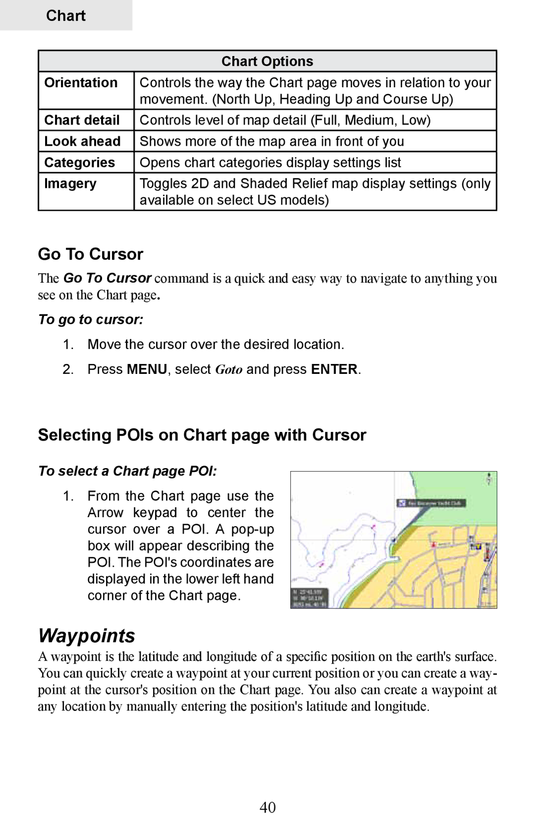
Selecting POIs on Chart page with Cursor
To select a Chart page POI
Go To Cursor
Waypoint menu
Create Waypoint from Chart
To create a Waypoint at the cursors position
To create a Waypoint at the Vessels position
Waypoints screen
Waypoints screen menu
Waypoint Information screen
Waypoints screen, Search for Waypoint by name
Waypoints screen, Sort Waypoints
To Search for Waypoint by Name
Editing a Waypoint on the Chart
To Edit a Waypoint from the Chart
Edit Waypoint menu
Edit Waypoint icon and color
To Edit Waypoint depth or alarm radius
Edit Waypoint name, description, position or depth
To Edit Waypoint name or description
Create Route from Chart
To Create a New Route from the Chart
Routes
Routes screen
Routes screen menu
To Edit Route
To Display / Hide Route
To Insert, Edit or Remove Waypoints from a Route
To Navigate Route from Routes screen
To Search for Route by Name
Trails
Trails screen
Trails screen menu
To Create a New Trail
New Trail menu
Edit Trail menu
To edit a Trail name
Measuring Distances on Chart
To select/deselect Measure feature
Trail line Color options
To search for specific Chart page item
Find Chart item
To search for Chart page POI using coordinates
Search by Coordinates
Map Orientation
To change Chart page orientation
To select / deselect the Look Ahead feature
Look Ahead
2D and Shaded Relief
Chart categories
To select / deselect Chart Categories
Shaded Relief only available on U.S. Insight models
Chart page Icons, Tides and Currents
Radar Overlay
To turn on radar overlay
Navionics
Radar Options
To view Navionics data
Navionics Settings menu
Navionics Settings and Options
To change Navionics Settings
Platinum or Platinum Plus charts
To access the Radar
Radar Operation optional
Radar menu
Adjust menu
To access the Adjust menu
Radar State
Auto Gain
Low, Medium and High
To select Auto Gain
Position
Sea Clutter
Acquire Targets
To change the PPI position
Symbology
Offset
EBL/VRM menu
Adjust
To adjust an EBL/VRM
To select an EBL/VRM
Guard Zones
Data Box
Radar Overlay
Using the Adjust menu
To choose alarm trigger vessels entering or exiting zones
To turn on a Guard Zone
System
Settings Menu
To access the System menu
Language
Key Beeps
To change Key Beep settings
To change Text Size
Time optional
To select a Datum
To change magnetic variation settings
Datum
Coord System
Satellites
Screen Capture
To take a screen capture
To save screen captures to MMC/SD card
To adjust Waypoint, Hardware and Radar settings
Restore Defaults
To access Advanced Settings
Advanced
Pages
Navigation
To select a Logging Type
Trails
Logging Type
Distance Period
To set Time Period
To set up phantom loran
Time Period
Phantom Loran
To access the Chart Settings Menu
Chart Settings Menu
Chart Data
Range Rings
Waypoints
Popup Information
Grid Lines
To use Heading Extension
Hide Chart
Routes
Trails
Noise Rejection
Sonar Settings HDS-8 &10
Network Sonar
Surface Clarity
Manual Mode
To adjust Surface Clarity
Scroll Speed
Fishing Modes
Installation Menu
Reset Fishing Mode
Keel Offset
Water Speed Calibration
To set Keel Offset
To calibrate Water Speed
Water Speed Averaging
Temperature Calibration
Temperature Averaging
To select a Water Averaging interval
To select a Temperature Averaging interval
Transducer Type
To select a Transducer Type
Target Trails
Radar Settings Menu optional
Target Expansion
Palette
Threshold
North Indicator
Orientation
To change Map Orientation
Range Markers
Compass
Bearings
Marpa
To set T/M or R
To adjust CPA and Tcpa settings
Canceling Marpa targets
Selecting Marpa targets
Marpa Settings
To cancel individual targets
To cancel all targets
To select history length
To set Marpa target alarm
Installation
Target Alarms
To access Radar Installation menu
Installation Adjustment Menu
Bearing alignment
To select Heading up orientation
To Adjust Bearing Alignment
To Adjust Range Offset
Range offset
Antenna Height
Fast scan mode BR24 Radar only
To Adjust Antenna Height
Tune
Reset Radar to Factory Defaults
To make manual adjustments Sidelobe suppres- sion
Sidelobe suppression BR24 only
Fuel
Refuel
To input fuel added
To set tank to full
To calibrate engines
Vessel Setup
100
Fuel Used
101
Engine/Tank Configuration
To select engine-tank configuration
To input tank size
Alarms
To enable/disable an Alarm
102
Siren Enabled
Units
103
Network
104
105
106
Configuring Devices
To configure a device name or device tank size
107
108
To configure device location
To access calibration instructions
Instance
109
Diagnostics
To configure serial ports
Nmea 2000 receive/send waypoint
110
Mmsi Maritime Mobile Service Identity
To access Nmea 0183 Output screen
Nmea 0183 Output
111
Simulator
Demo Mode
To choose a Demo Mode
112
113
To select a route
114
Route
Set Start Position
Specifications HDS-8/8m & HDS-10/10m
115
Unit Care
116
Unit freezes, locks up, or operates erratically
Troubleshooting
Unit won’t turn on
Weak bottom echo, erratic readings or no fish returns
118
No fish arches when Fish I.D. is turned off
119
Noise
120
GPS Not Accurate
121
Cards not Read by Unit
Current Position not on the Screen
122
Radar won’t Start Up
Update the Software
Reset the Unit
123
124
Index
125
126
EBL/VRM
127
128
Navico Databases License Agreement
Databases Limited Warranty