Xperia E
Contents
Walkman application
Calendar Alarm clock
About Movies Using Movies
Limitations to services and features
Important information leaflet
Legal information
Xperia E User guide
What is Android?
Getting started
Phone overview
Page
To remove the memory card
Assembly
To remove the battery cover
To insert a memory card
To insert the battery
To remove the battery
To remove the SIM card
Tap OK
Options menu, tap Power off
Turning the phone on and off
Screen lock
Accounts and services
Setup guide
Getting to know your phone
Using the keys
Battery
Charging the battery
To access the battery usage menu
Battery LED status
Improving battery performance
To check the battery level
Using the touchscreen
Reducing battery consumption with Power Saver
Marking options
Scrolling
Zooming
To go to the Home screen
Home screen
Sensors
To flick
Rearranging your Home screen
Widgets
Application screen
Accessing and using applications
Taking a screenshot
Changing the background of your Home screen
Opening and closing applications
Recently used applications window
Application menu
Status and notifications
Rearranging your Application screen
Checking notifications and ongoing activities
Setting your phone from the Notification panel
On-screen keyboard
Phone settings menu
Using the on-screen keyboard
Typing text
Select a smiley
When you enter text, touch and hold
Application bar
Using the Gesture input function to write words
To enter text using the Gesture input function
To change the Gesture input settings
To enter numbers using the Phonepad
Using the Phonepad
To switch between the on-screen keyboard and the Phonepad
To enter text using the Phonepad
Customizing your phone
Keyboard and Phonepad settings
Text input settings
Adjusting the volume
Time and date
Ringtone settings
Screen settings
Flight mode
Phone language
Memory
Memory card
Formatting the memory card
To view the current Access Point Name APN
Using a headset with your phone
Internet and messaging settings
To download Internet and messaging settings
Controlling data usage
Turning off data traffic
Mobile network settings
To activate data roaming
Data roaming
Before you download applications
Google Play
Getting started with Google Play
Downloading from Google Play
Installing applications not from Google Play
Clearing your application data
Permissions
Calling
Emergency calls
Call handling
Recent calls
Voicemail
Enter the number of the recipient and tap
Multiple calls
Conference calls
During an ongoing call, tap
Forwarding calls
Call settings
Barring calls
Rejecting a call with a message
To enable or disable fixed dialing
To access the list of accepted call recipients
Fixed Dialing Numbers
Transferring contacts to your new phone
Transferring contacts using a PC
Contacts
About Contacts
Transferring contacts from a SIM card
Using the PC Companion program to transfer contacts
Transferring contacts using an Apple Mac computer
Transferring contacts using synchronization accounts
Receiving contacts from other devices
Managing your contacts
Avoiding duplicate entries in the Contacts application
Favorites
Press , then tap Delete contacts
Quick contact menu
Communicating with your contacts
Sharing your contacts
Groups
Press , then tap Back up contacts SIM card
Backing up contacts
To export all contacts to a memory card
To export contacts to a SIM card
Messaging
Using text and multimedia messaging
Press
Press , then tap Settings
Google Talk
From your Home screen, tap , then tap Messaging
To reply to an instant message with Talk
To start Google Talk
Using email accounts
Getting started with Email
Find and tap
Find and tap Gmail
Using e-mail
Gmail and other Google services
From the Home screen, tap
To save a senders email address to your contacts
To receive email messages
To read your email messages
To view an email message attachment
To star an email
To forward an email message
To delete an email message
To mark a read email as unread
To change the inbox check frequency
Walkman application overview
Walkman application
About Music
Copying media files to your memory card
Using the Walkman player
Discovering related audio content
Using My music to organize your tracks
Overview of My music
Playing music in random order
Categorizing your music using SensMe channels
Walkman player widget
Playlists
TrackID technology
Identifying music using TrackID technology
Using TrackID technology results
Protecting your hearing
PlayNow service
About the PlayNow service
Before you download content
FM radio overview
FM radio
About the FM radio
Moving between radio channels
Switching between the speaker and the handsfree
Using your favorite radio channels
Sound settings
Identifying radio tracks using TrackID
Camera controls overview
Tips on using the camera
Camera
About the camera
Adding the geographical position to your photos
Taking photos with the still camera
Press , then tap Geotagging On
Still camera settings overview Scenes
Exposure value
White balance
Geotagging
Self-timer
To record a video using the camera key
Recording videos
Tap to play a video
Video camera settings
Video camera settings overview Scenes
If the video camera is not selected, drag to
Self timer
Microphone
Shutter sound
Album tab overview
Album
Viewing photos and videos in Album
Viewing photos and videos saved in the phone
To view photos and videos in list view
To view photos and videos in grid view
Working with photos in Album
Working with videos in Album
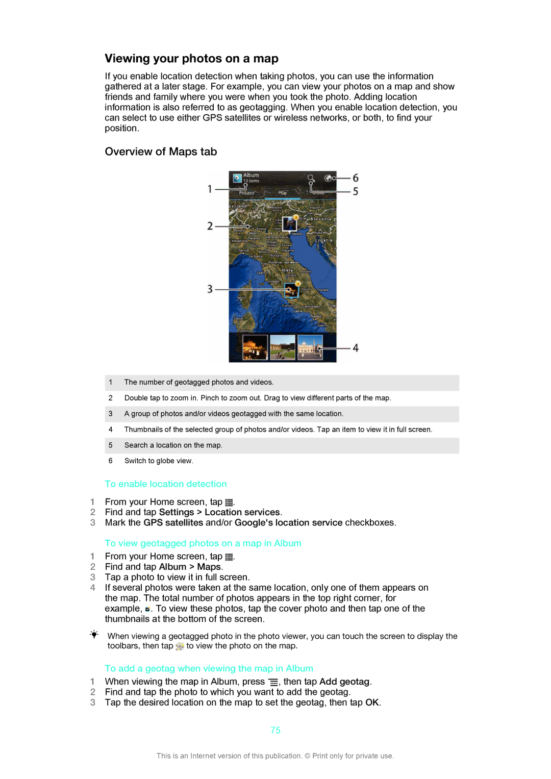
Overview of Maps tab
To enable location detection
To add a geotag when viewing the map in Album
Viewing your photos on a map
Overview of Online tab
Viewing your online albums
To recommend a photo or video on Facebook
Using Movies
Movies
About Movies
Navigating web pages
Web browser
About the web browser
Browsing the web
When an offline web page is open, press
Managing bookmarks
Tap Go live
To add a bookmarked webpage to your Home screen
To bookmark a web
To open a bookmark
To edit a bookmark
Multiple windows
Managing text and images
Browser settings
Downloading from the web
Auto-fitting web pages
To create text for auto-filling
Plugin settings
To enable plug-ins on demand
Auto-filling text
Connecting to wireless networks
Wi-Fi
Connectivity
Sharing your phone’s mobile data connection
Advanced Wi-Fi settings
Wi-Fi network status
Wi-Fi sleep policy
To rename or secure your portable hotspot
Bluetooth wireless technology
To share your data connection using a USB cable
To use your device as a portable Wi-Fi hotspot
Naming your phone
Pairing with another Bluetooth device
Connecting your phone to a computer
Sending and receiving items using Bluetooth technology
Transferring and handling content using a USB cable
PC Companion
Transferring files using Media transfer mode via Wi-Fi
To connect paired devices wirelessly in Media transfer mode
To remove a pairing with another device
Scanning barcodes with the NeoReader application
Media Go
About scanning with the NeoReader application
NeoReader application menu overview
Synchronizing your corporate email, calendar and contacts
Synchronizing data on your phone
About synchronizing data on your phone
Synchronizing with Google
Synchronizing with Facebook
To set a synchronization interval for a corporate account
To remove a corporate account from your phone
Synchronizing using SyncML
To remove a SyncML account from your phone
Google Maps
About location services
Using GPS
Maps and locations
Using Google Maps to get directions
Using the Navigation application
Viewing your friends’ locations with Google Latitude
Calendar
Calendar and alarm clock
Alarm clock
About the alarm clock
To activate an existing alarm
To set a new alarm
To edit an existing alarm
To deactivate an alarm
To snooze an alarm when it sounds
To set the title for an alarm
To activate the vibrate function for an alarm
To set alarms to sound when the phone is in silent mode
Find and tap Update Center
Support and maintenance
Updating your phone wirelessly
Updating your phone using a USB cable connection
Locking and protecting your phone
Imei number
SIM card protection
Select an option
From your Home screen, tap Settings Security Screen lock
Finding your device
Find and tap the required support item
To access the Help application
Recycling your phone
From your Application screen, find and tap
Phone settings overview
Reference
107
108
Status and notification icons overview
Status icons
Notification icons
109
Application overview
110
Legal information
Limitations to services and features
Important information
Important information leaflet