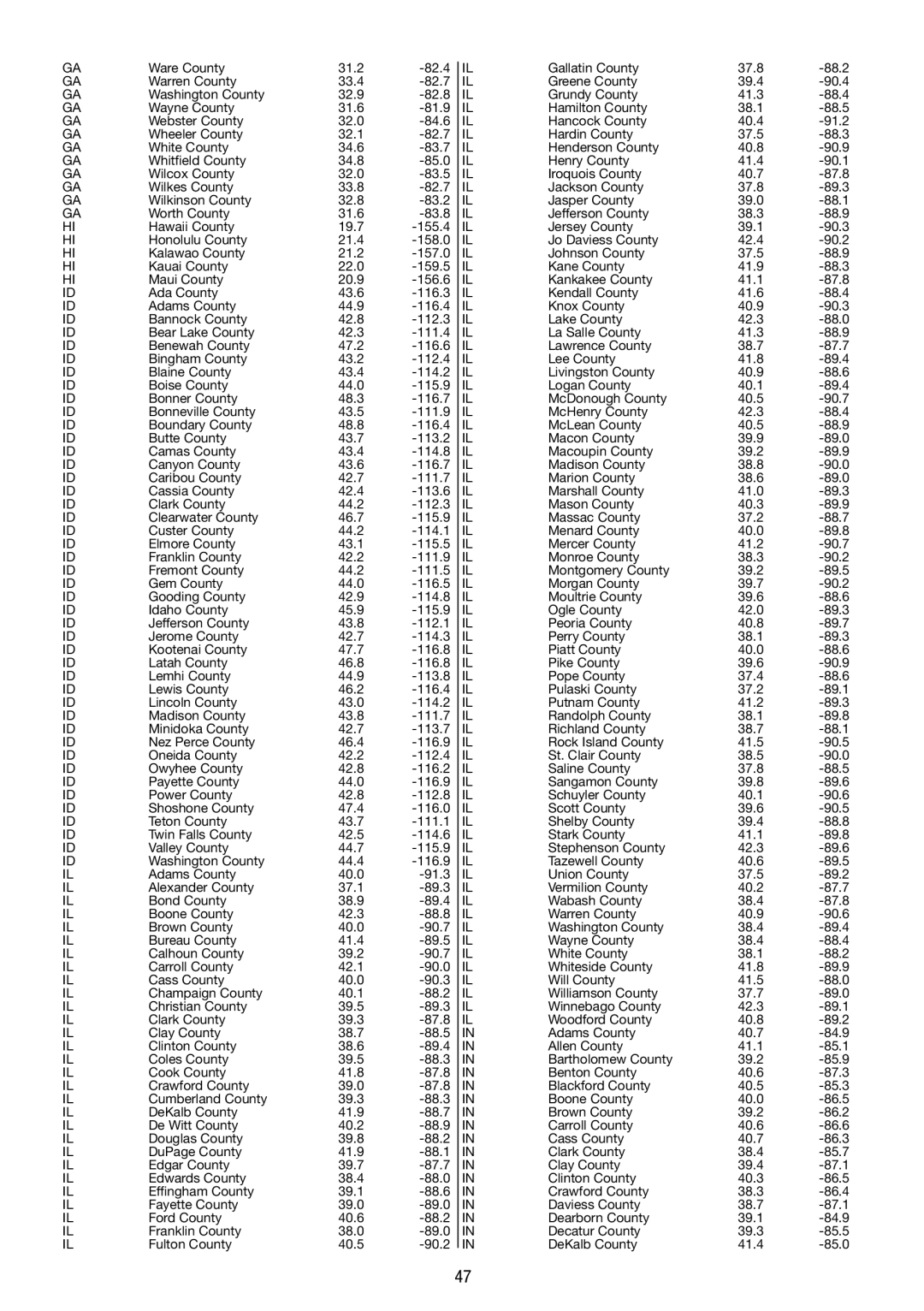
GA

Ware County

31.2

-82.4


IL

Gallatin County

37.8

-88.2

GA

Warren County

33.4

-82.7


IL

Greene County

39.4

-90.4

GA

Washington County

32.9

-82.8


IL

Grundy County

41.3

-88.4

GA

Wayne County

31.6

-81.9


IL

Hamilton County

38.1

-88.5

GA

Webster County

32.0

-84.6


IL

Hancock County

40.4

-91.2

GA

Wheeler County

32.1

-82.7


IL

Hardin County

37.5

-88.3

GA

White County

34.6

-83.7


IL

Henderson County

40.8

-90.9

GA

Whitfield County

34.8

-85.0


IL

Henry County

41.4

-90.1

GA

Wilcox County

32.0

-83.5


IL

Iroquois County

40.7

-87.8

GA

Wilkes County

33.8

-82.7


IL

Jackson County

37.8

-89.3

GA

Wilkinson County

32.8

-83.2


IL

Jasper County

39.0

-88.1

GA

Worth County

31.6

-83.8


IL

Jefferson County

38.3

-88.9

HI

Hawaii County

19.7

-155.4


IL

Jersey County

39.1

-90.3

HI

Honolulu County

21.4

-158.0


IL

Jo Daviess County

42.4

-90.2

HI

Kalawao County

21.2

-157.0


IL

Johnson County

37.5

-88.9

HI

Kauai County

22.0

-159.5


IL

Kane County

41.9

-88.3

HI

Maui County

20.9

-156.6


IL

Kankakee County

41.1

-87.8

ID

Ada County

43.6

-116.3


IL

Kendall County

41.6

-88.4

ID

Adams County

44.9

-116.4


IL

Knox County

40.9

-90.3

ID

Bannock County

42.8

-112.3


IL

Lake County

42.3

-88.0

ID

Bear Lake County

42.3

-111.4


IL

La Salle County

41.3

-88.9

ID

Benewah County

47.2

-116.6


IL

Lawrence County

38.7

-87.7

ID

Bingham County

43.2

-112.4


IL

Lee County

41.8

-89.4

ID

Blaine County

43.4

-114.2


IL

Livingston County

40.9

-88.6

ID

Boise County

44.0

-115.9


IL

Logan County

40.1

-89.4

ID

Bonner County

48.3

-116.7


IL

McDonough County

40.5

-90.7

ID

Bonneville County

43.5

-111.9


IL

McHenry County

42.3

-88.4

ID

Boundary County

48.8

-116.4


IL

McLean County

40.5

-88.9

ID

Butte County

43.7

-113.2


IL

Macon County

39.9

-89.0

ID

Camas County

43.4

-114.8


IL

Macoupin County

39.2

-89.9

ID

Canyon County

43.6

-116.7


IL

Madison County

38.8

-90.0

ID

Caribou County

42.7

-111.7


IL

Marion County

38.6

-89.0

ID

Cassia County

42.4

-113.6


IL

Marshall County

41.0

-89.3

ID

Clark County

44.2

-112.3


IL

Mason County

40.3

-89.9

ID

Clearwater County

46.7

-115.9


IL

Massac County

37.2

-88.7

ID

Custer County

44.2

-114.1


IL

Menard County

40.0

-89.8

ID

Elmore County

43.1

-115.5


IL

Mercer County

41.2

-90.7

ID

Franklin County

42.2

-111.9


IL

Monroe County

38.3

-90.2

ID

Fremont County

44.2

-111.5


IL

Montgomery County

39.2

-89.5

ID

Gem County

44.0

-116.5


IL

Morgan County

39.7

-90.2

ID

Gooding County

42.9

-114.8


IL

Moultrie County

39.6

-88.6

ID

Idaho County

45.9

-115.9


IL

Ogle County

42.0

-89.3

ID

Jefferson County

43.8

-112.1


IL

Peoria County

40.8

-89.7

ID

Jerome County

42.7

-114.3


IL

Perry County

38.1

-89.3

ID

Kootenai County

47.7

-116.8


IL

Piatt County

40.0

-88.6

ID

Latah County

46.8

-116.8


IL

Pike County

39.6

-90.9

ID

Lemhi County

44.9

-113.8


IL

Pope County

37.4

-88.6

ID

Lewis County

46.2

-116.4


IL

Pulaski County

37.2

-89.1

ID

Lincoln County

43.0

-114.2


IL

Putnam County

41.2

-89.3

ID

Madison County

43.8

-111.7


IL

Randolph County

38.1

-89.8

ID

Minidoka County

42.7

-113.7


IL

Richland County

38.7

-88.1

ID

Nez Perce County

46.4

-116.9


IL

Rock Island County

41.5

-90.5

ID

Oneida County

42.2

-112.4


IL

St. Clair County

38.5

-90.0

ID

Owyhee County

42.8

-116.2


IL

Saline County

37.8

-88.5

ID

Payette County

44.0

-116.9


IL

Sangamon County

39.8

-89.6

ID

Power County

42.8

-112.8


IL

Schuyler County

40.1

-90.6

ID

Shoshone County

47.4

-116.0


IL

Scott County

39.6

-90.5

ID

Teton County

43.7

-111.1


IL

Shelby County

39.4

-88.8

ID

Twin Falls County

42.5

-114.6


IL

Stark County

41.1

-89.8

ID

Valley County

44.7

-115.9


IL

Stephenson County

42.3

-89.6

ID

Washington County

44.4

-116.9


IL

Tazewell County

40.6

-89.5

IL

Adams County

40.0

-91.3


IL

Union County

37.5

-89.2

IL

Alexander County

37.1

-89.3


IL

Vermilion County

40.2

-87.7

IL

Bond County

38.9

-89.4


IL

Wabash County

38.4

-87.8

IL

Boone County

42.3

-88.8


IL

Warren County

40.9

-90.6

IL

Brown County

40.0

-90.7


IL

Washington County

38.4

-89.4

IL

Bureau County

41.4

-89.5


IL

Wayne County

38.4

-88.4

IL

Calhoun County

39.2

-90.7


IL

White County

38.1

-88.2

IL

Carroll County

42.1

-90.0


IL

Whiteside County

41.8

-89.9

IL

Cass County

40.0

-90.3


IL

Will County

41.5

-88.0

IL

Champaign County

40.1

-88.2


IL

Williamson County

37.7

-89.0

IL

Christian County

39.5

-89.3


IL

Winnebago County

42.3

-89.1

IL

Clark County

39.3

-87.8


IL

Woodford County

40.8

-89.2

IL

Clay County

38.7

-88.5


IN

Adams County

40.7

-84.9

IL

Clinton County

38.6

-89.4


IN

Allen County

41.1

-85.1

IL

Coles County

39.5

-88.3


IN

Bartholomew County

39.2

-85.9

IL

Cook County

41.8

-87.8


IN

Benton County

40.6

-87.3

IL

Crawford County

39.0

-87.8


IN

Blackford County

40.5

-85.3

IL

Cumberland County

39.3

-88.3


IN

Boone County

40.0

-86.5

IL

DeKalb County

41.9

-88.7


IN

Brown County

39.2

-86.2

IL

De Witt County

40.2

-88.9


IN

Carroll County

40.6

-86.6

IL

Douglas County

39.8

-88.2


IN

Cass County

40.7

-86.3

IL

DuPage County

41.9

-88.1


IN

Clark County

38.4

-85.7

IL

Edgar County

39.7

-87.7


IN

Clay County

39.4

-87.1

IL

Edwards County

38.4

-88.0


IN

Clinton County

40.3

-86.5

IL

Effingham County

39.1

-88.6


IN

Crawford County

38.3

-86.4

IL

Fayette County

39.0

-89.0


IN

Daviess County

38.7

-87.1

IL

Ford County

40.6

-88.2


IN

Dearborn County

39.1

-84.9

IL

Franklin County

38.0

-89.0


IN

Decatur County

39.3

-85.5

IL

Fulton County

40.5

-90.2


IN

DeKalb County

41.4

-85.0


47

Page 47
Image 47
La Crosse Technology WS 550 US operating instructions

WS 550 US specifications

The La Crosse Technology WS 550 US is an advanced weather station designed for both amateur meteorologists and weather enthusiasts. It seamlessly combines cutting-edge technology with user-friendly features, capturing comprehensive meteorological data for intuitive analysis and real-time monitoring.

At the heart of the WS 550 US is its wireless sensor technology. This weather station includes an outdoor sensor that accurately measures temperature, humidity, wind speed, wind direction, and rainfall. The wireless connection allows for a convenient setup, as users can place the sensor up to 300 feet away from the display console. This flexibility ensures optimal placement for accurate readings while maintaining easy access to the display.

One of the standout features of the WS 550 US is its large, easy-to-read LCD screen, which displays a wealth of information at a glance. The console shows indoor and outdoor temperatures, humidity levels, wind speeds, and weather forecasts based on barometric pressure changes. The multi-functional display provides a clear summary of current conditions, making it easier for users to prepare for changing weather patterns.

In addition to real-time data, the WS 550 US also boasts a unique alarm system for severe weather conditions. Users can set up personalized alerts for high and low temperature thresholds, humidity levels, and rainfall amounts. This proactive feature gives users peace of mind, allowing them to respond to potential weather hazards quickly.

The WS 550 US integrates advanced forecasting technology, utilizing a built-in barometer to predict weather changes up to 12-24 hours in advance. The included historical data feature allows users to review past weather patterns, granting insights into local climatic trends and forecasting.

Another admirable aspect of this weather station is its compatibility with La Crosse's mobile app, enabling users to access their weather data remotely. This feature is particularly appealing in today’s digital age, making monitoring weather conditions possible from smartphones and tablets.

With its combination of advanced technology and user-oriented features, the La Crosse Technology WS 550 US provides reliable and accurate weather data, appealing to anyone interested in understanding the elements that shape our environment. Whether preparing for a gardening project, planning outdoor activities, or simply staying informed, this weather station stands out as a versatile tool in any setting.