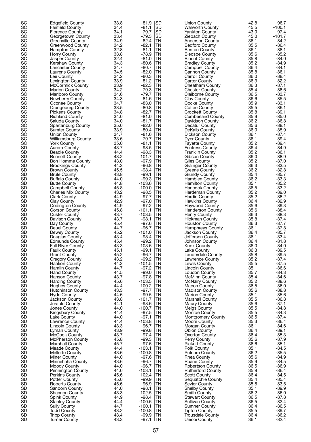
SC

Edgefield County

33.8

-81.9


SD

Union County

42.8

-96.7

SC

Fairfield County

34.4

-81.1


SD

Walworth County

45.5

-100.1

SC

Florence County

34.1

-79.7


SD

Yankton County

43.0

-97.4

SC

Georgetown County

33.4

-79.3


SD

Ziebach County

45.0

-101.7

SC

Greenville County

34.9

-82.4


TN

Anderson County

36.1

-84.2

SC

Greenwood County

34.2

-82.1


TN

Bedford County

35.5

-86.4

SC

Hampton County

32.8

-81.1


TN

Benton County

36.1

-88.1

SC

Horry County

33.8

-78.9


TN

Bledsoe County

35.6

-85.2

SC

Jasper County

32.4

-81.0


TN

Blount County

35.8

-84.0

SC

Kershaw County

34.3

-80.6


TN

Bradley County

35.2

-84.9

SC

Lancaster County

34.7

-80.7


TN

Campbell County

36.4

-84.1

SC

Laurens County

34.5

-82.0


TN

Cannon County

35.8

-86.1

SC

Lee County

34.2

-80.3


TN

Carroll County

36.0

-88.4

SC

Lexington County

33.9

-81.2


TN

Carter County

36.3

-82.2

SC

McCormick County

33.9

-82.3


TN

Cheatham County

36.3

-87.1

SC

Marion County

34.2

-79.3


TN

Chester County

35.4

-88.6

SC

Marlboro County

34.6

-79.7


TN

Claiborne County

36.5

-83.7

SC

Newberry County

34.3

-81.6


TN

Clay County

36.6

-85.5

SC

Oconee County

34.7

-83.0


TN

Cocke County

35.9

-83.1

SC

Orangeburg County

33.5

-80.8


TN

Coffee County

35.5

-86.1

SC

Pickens County

34.8

-82.7


TN

Crockett County

35.8

-89.1

SC

Richland County

34.0

-81.0


TN

Cumberland County

35.9

-85.0

SC

Saluda County

34.0

-81.7


TN

Davidson County

36.2

-86.8

SC

Spartanburg County

35.0

-82.0


TN

Decatur County

35.6

-88.1

SC

Sumter County

33.9

-80.4


TN

DeKalb County

36.0

-85.9

SC

Union County

34.7

-81.6


TN

Dickson County

36.1

-87.4

SC

Williamsburg County

33.6

-79.7


TN

Dyer County

36.1

-89.4

SC

York County

35.0

-81.1


TN

Fayette County

35.2

-89.4

SD

Aurora County

43.7

-98.5


TN

Fentress County

36.4

-84.9

SD

Beadle County

44.4

-98.3


TN

Franklin County

35.2

-86.1

SD

Bennett County

43.2

-101.7


TN

Gibson County

36.0

-88.9

SD

Bon Homme County

43.0

-97.9


TN

Giles County

35.2

-87.0

SD

Brookings County

44.3

-96.8


TN

Grainger County

36.3

-83.5

SD

Brown County

45.5

-98.4


TN

Greene County

36.2

-82.8

SD

Brule County

43.8

-99.1


TN

Grundy County

35.4

-85.7

SD

Buffalo County

44.0

-99.3


TN

Hamblen County

36.2

-83.3

SD

Butte County

44.8

-103.6


TN

Hamilton County

35.1

-85.2

SD

Campbell County

45.8

-100.0


TN

Hancock County

36.5

-83.2

SD

Charles Mix County

43.2

-98.5


TN

Hardeman County

35.2

-89.0

SD

Clark County

44.9

-97.7


TN

Hardin County

35.2

-88.2

SD

Clay County

42.9

-97.0


TN

Hawkins County

36.4

-82.9

SD

Codington County

44.9

-97.2


TN

Haywood County

35.6

-89.3

SD

Corson County

45.8

-101.1


TN

Henderson County

35.6

-88.4

SD

Custer County

43.7

-103.5


TN

Henry County

36.3

-88.3

SD

Davison County

43.7

-98.1


TN

Hickman County

35.8

-87.4

SD

Day County

45.4

-97.6


TN

Houston County

36.3

-87.7

SD

Deuel County

44.7

-96.7


TN

Humphreys County

36.1

-87.8

SD

Dewey County

45.2

-101.0


TN

Jackson County

36.4

-85.7

SD

Douglas County

43.4

-98.4


TN

Jefferson County

36.1

-83.4

SD

Edmunds County

45.4

-99.2


TN

Johnson County

36.4

-81.8

SD

Fall River County

43.3

-103.6


TN

Knox County

36.0

-84.0

SD

Faulk County

45.1

-99.1


TN

Lake County

36.3

-89.5

SD

Grant County

45.2

-96.7


TN

Lauderdale County

35.8

-89.5

SD

Gregory County

43.2

-99.2


TN

Lawrence County

35.2

-87.4

SD

Haakon County

44.2

-101.5


TN

Lewis County

35.5

-87.5

SD

Hamlin County

44.7

-97.2


TN

Lincoln County

35.1

-86.6

SD

Hand County

44.5

-99.0


TN

Loudon County

35.7

-84.3

SD

Hanson County

43.7

-97.8


TN

McMinn County

35.4

-84.6

SD

Harding County

45.6

-103.5


TN

McNairy County

35.2

-88.6

SD

Hughes County

44.4

-100.2


TN

Macon County

36.5

-86.0

SD

Hutchinson County

43.3

-97.7


TN

Madison County

35.6

-88.8

SD

Hyde County

44.6

-99.5


TN

Marion County

35.1

-85.6

SD

Jackson County

43.8

-101.7


TN

Marshall County

35.5

-86.8

SD

Jerauld County

44.1

-98.6


TN

Maury County

35.6

-87.1

SD

Jones County

44.0

-100.7


TN

Meigs County

35.5

-84.8

SD

Kingsbury County

44.4

-97.5


TN

Monroe County

35.5

-84.3

SD

Lake County

44.0

-97.1


TN

Montgomery County

36.5

-87.4

SD

Lawrence County

44.4

-103.8


TN

Moore County

35.3

-86.4

SD

Lincoln County

43.3

-96.7


TN

Morgan County

36.1

-84.6

SD

Lyman County

43.9

-99.8


TN

Obion County

36.4

-89.1

SD

McCook County

43.7

-97.4


TN

Overton County

36.4

-85.3

SD

McPherson County

45.8

-99.3


TN

Perry County

35.6

-87.9

SD

Marshall County

45.7

-97.6


TN

Pickett County

36.6

-85.1

SD

Meade County

44.4

-103.1


TN

Polk County

35.1

-84.5

SD

Mellette County

43.6

-100.8


TN

Putnam County

36.2

-85.5

SD

Miner County

44.0

-97.6


TN

Rhea County

35.6

-84.9

SD

Minnehaha County

43.6

-96.7


TN

Roane County

35.9

-84.5

SD

Moody County

44.0

-96.7


TN

Robertson County

36.5

-86.9

SD

Pennington County

44.0

-103.1


TN

Rutherford County

35.9

-86.4

SD

Perkins County

45.6

-102.4


TN

Scott County

36.4

-84.5

SD

Potter County

45.0

-99.9


TN

Sequatchie County

35.4

-85.4

SD

Roberts County

45.6

-96.9


TN

Sevier County

35.8

-83.5

SD

Sanborn County

44.0

-98.1


TN

Shelby County

35.1

-89.9

SD

Shannon County

43.3

-102.5


TN

Smith County

36.2

-86.0

SD

Spink County

44.9

-98.4


TN

Stewart County

36.5

-87.8

SD

Stanley County

44.4

-100.6


TN

Sullivan County

36.5

-82.4

SD

Sully County

44.7

-100.1


TN

Sumner County

36.4

-86.5

SD

Todd County

43.2

-100.8


TN

Tipton County

35.5

-89.7

SD

Tripp County

43.4

-99.9


TN

Trousdale County

36.4

-86.2

SD

Turner County

43.3

-97.1


TN

Unicoi County

36.1

-82.4


57

Page 57
Image 57
La Crosse Technology WS 550 US operating instructions

WS 550 US specifications

The La Crosse Technology WS 550 US is an advanced weather station designed for both amateur meteorologists and weather enthusiasts. It seamlessly combines cutting-edge technology with user-friendly features, capturing comprehensive meteorological data for intuitive analysis and real-time monitoring.

At the heart of the WS 550 US is its wireless sensor technology. This weather station includes an outdoor sensor that accurately measures temperature, humidity, wind speed, wind direction, and rainfall. The wireless connection allows for a convenient setup, as users can place the sensor up to 300 feet away from the display console. This flexibility ensures optimal placement for accurate readings while maintaining easy access to the display.

One of the standout features of the WS 550 US is its large, easy-to-read LCD screen, which displays a wealth of information at a glance. The console shows indoor and outdoor temperatures, humidity levels, wind speeds, and weather forecasts based on barometric pressure changes. The multi-functional display provides a clear summary of current conditions, making it easier for users to prepare for changing weather patterns.

In addition to real-time data, the WS 550 US also boasts a unique alarm system for severe weather conditions. Users can set up personalized alerts for high and low temperature thresholds, humidity levels, and rainfall amounts. This proactive feature gives users peace of mind, allowing them to respond to potential weather hazards quickly.

The WS 550 US integrates advanced forecasting technology, utilizing a built-in barometer to predict weather changes up to 12-24 hours in advance. The included historical data feature allows users to review past weather patterns, granting insights into local climatic trends and forecasting.

Another admirable aspect of this weather station is its compatibility with La Crosse's mobile app, enabling users to access their weather data remotely. This feature is particularly appealing in today’s digital age, making monitoring weather conditions possible from smartphones and tablets.

With its combination of advanced technology and user-oriented features, the La Crosse Technology WS 550 US provides reliable and accurate weather data, appealing to anyone interested in understanding the elements that shape our environment. Whether preparing for a gardening project, planning outdoor activities, or simply staying informed, this weather station stands out as a versatile tool in any setting.