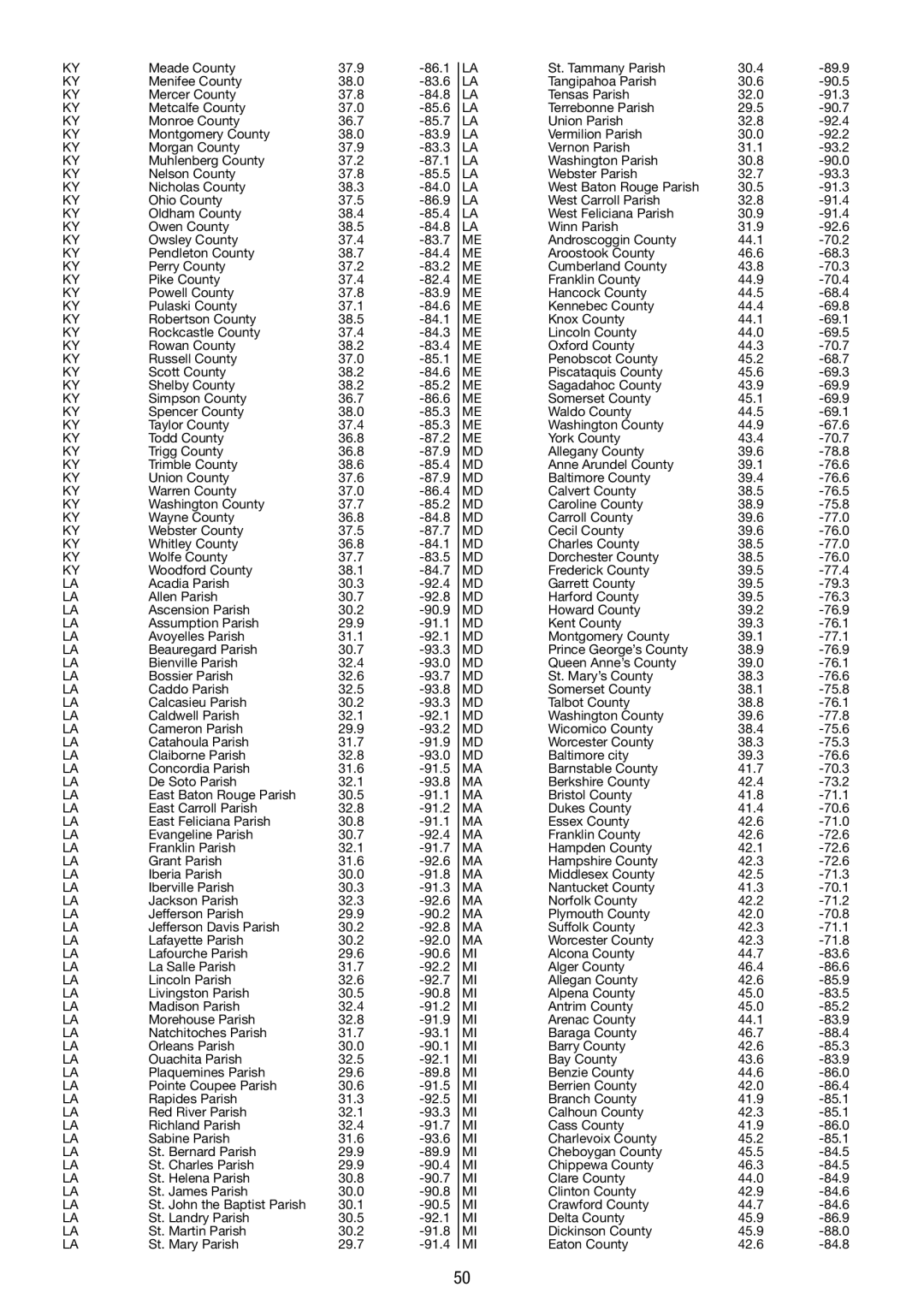
KY

Meade County

37.9

-86.1


LA

KY

Menifee County

38.0

-83.6


LA

KY

Mercer County

37.8

-84.8


LA

KY

Metcalfe County

37.0

-85.6


LA

KY

Monroe County

36.7

-85.7


LA

KY

Montgomery County

38.0

-83.9


LA

KY

Morgan County

37.9

-83.3


LA

KY

Muhlenberg County

37.2

-87.1


LA

KY

Nelson County

37.8

-85.5


LA

KY

Nicholas County

38.3

-84.0


LA

KY

Ohio County

37.5

-86.9


LA

KY

Oldham County

38.4

-85.4


LA

KY

Owen County

38.5

-84.8


LA

KY

Owsley County

37.4

-83.7


ME

KY

Pendleton County

38.7

-84.4


ME

KY

Perry County

37.2

-83.2


ME

KY

Pike County

37.4

-82.4


ME

KY

Powell County

37.8

-83.9


ME

KY

Pulaski County

37.1

-84.6


ME

KY

Robertson County

38.5

-84.1


ME

KY

Rockcastle County

37.4

-84.3


ME

KY

Rowan County

38.2

-83.4


ME

KY

Russell County

37.0

-85.1


ME

KY

Scott County

38.2

-84.6


ME

KY

Shelby County

38.2

-85.2


ME

KY

Simpson County

36.7

-86.6


ME

KY

Spencer County

38.0

-85.3


ME

KY

Taylor County

37.4

-85.3


ME

KY

Todd County

36.8

-87.2


ME

KY

Trigg County

36.8

-87.9


MD

KY

Trimble County

38.6

-85.4


MD

KY

Union County

37.6

-87.9


MD

KY

Warren County

37.0

-86.4


MD

KY

Washington County

37.7

-85.2


MD

KY

Wayne County

36.8

-84.8


MD

KY

Webster County

37.5

-87.7


MD

KY

Whitley County

36.8

-84.1


MD

KY

Wolfe County

37.7

-83.5


MD

KY

Woodford County

38.1

-84.7


MD

LA

Acadia Parish

30.3

-92.4


MD

LA

Allen Parish

30.7

-92.8


MD

LA

Ascension Parish

30.2

-90.9


MD

LA

Assumption Parish

29.9

-91.1


MD

LA

Avoyelles Parish

31.1

-92.1


MD

LA

Beauregard Parish

30.7

-93.3


MD

LA

Bienville Parish

32.4

-93.0


MD

LA

Bossier Parish

32.6

-93.7


MD

LA

Caddo Parish

32.5

-93.8


MD

LA

Calcasieu Parish

30.2

-93.3


MD

LA

Caldwell Parish

32.1

-92.1


MD

LA

Cameron Parish

29.9

-93.2


MD

LA

Catahoula Parish

31.7

-91.9


MD

LA

Claiborne Parish

32.8

-93.0


MD

LA

Concordia Parish

31.6

-91.5


MA

LA

De Soto Parish

32.1

-93.8


MA

LA

East Baton Rouge Parish

30.5

-91.1


MA

LA

East Carroll Parish

32.8

-91.2


MA

LA

East Feliciana Parish

30.8

-91.1


MA

LA

Evangeline Parish

30.7

-92.4


MA

LA

Franklin Parish

32.1

-91.7


MA

LA

Grant Parish

31.6

-92.6


MA

LA

Iberia Parish

30.0

-91.8


MA

LA

Iberville Parish

30.3

-91.3


MA

LA

Jackson Parish

32.3

-92.6


MA

LA

Jefferson Parish

29.9

-90.2


MA

LA

Jefferson Davis Parish

30.2

-92.8


MA

LA

Lafayette Parish

30.2

-92.0


MA

LA

Lafourche Parish

29.6

-90.6


MI

LA

La Salle Parish

31.7

-92.2


MI

LA

Lincoln Parish

32.6

-92.7


MI

LA

Livingston Parish

30.5

-90.8


MI

LA

Madison Parish

32.4

-91.2


MI

LA

Morehouse Parish

32.8

-91.9


MI

LA

Natchitoches Parish

31.7

-93.1


MI

LA

Orleans Parish

30.0

-90.1


MI

LA

Ouachita Parish

32.5

-92.1


MI

LA

Plaquemines Parish

29.6

-89.8


MI

LA

Pointe Coupee Parish

30.6

-91.5


MI

LA

Rapides Parish

31.3

-92.5


MI

LA

Red River Parish

32.1

-93.3


MI

LA

Richland Parish

32.4

-91.7


MI

LA

Sabine Parish

31.6

-93.6


MI

LA

St. Bernard Parish

29.9

-89.9


MI

LA

St. Charles Parish

29.9

-90.4


MI

LA

St. Helena Parish

30.8

-90.7


MI

LA

St. James Parish

30.0

-90.8


MI

LA

St. John the Baptist Parish

30.1

-90.5


MI

LA

St. Landry Parish

30.5

-92.1


MI

LA

St. Martin Parish

30.2

-91.8


MI

LA

St. Mary Parish

29.7

-91.4


MI


St. Tammany Parish

30.4

-89.9

Tangipahoa Parish

30.6

-90.5

Tensas Parish

32.0

-91.3

Terrebonne Parish

29.5

-90.7

Union Parish

32.8

-92.4

Vermilion Parish

30.0

-92.2

Vernon Parish

31.1

-93.2

Washington Parish

30.8

-90.0

Webster Parish

32.7

-93.3

West Baton Rouge Parish

30.5

-91.3

West Carroll Parish

32.8

-91.4

West Feliciana Parish

30.9

-91.4

Winn Parish

31.9

-92.6

Androscoggin County

44.1

-70.2

Aroostook County

46.6

-68.3

Cumberland County

43.8

-70.3

Franklin County

44.9

-70.4

Hancock County

44.5

-68.4

Kennebec County

44.4

-69.8

Knox County

44.1

-69.1

Lincoln County

44.0

-69.5

Oxford County

44.3

-70.7

Penobscot County

45.2

-68.7

Piscataquis County

45.6

-69.3

Sagadahoc County

43.9

-69.9

Somerset County

45.1

-69.9

Waldo County

44.5

-69.1

Washington County

44.9

-67.6

York County

43.4

-70.7

Allegany County

39.6

-78.8

Anne Arundel County

39.1

-76.6

Baltimore County

39.4

-76.6

Calvert County

38.5

-76.5

Caroline County

38.9

-75.8

Carroll County

39.6

-77.0

Cecil County

39.6

-76.0

Charles County

38.5

-77.0

Dorchester County

38.5

-76.0

Frederick County

39.5

-77.4

Garrett County

39.5

-79.3

Harford County

39.5

-76.3

Howard County

39.2

-76.9

Kent County

39.3

-76.1

Montgomery County

39.1

-77.1

Prince George’s County

38.9

-76.9

Queen Anne’s County

39.0

-76.1

St. Mary’s County

38.3

-76.6

Somerset County

38.1

-75.8

Talbot County

38.8

-76.1

Washington County

39.6

-77.8

Wicomico County

38.4

-75.6

Worcester County

38.3

-75.3

Baltimore city

39.3

-76.6

Barnstable County

41.7

-70.3

Berkshire County

42.4

-73.2

Bristol County

41.8

-71.1

Dukes County

41.4

-70.6

Essex County

42.6

-71.0

Franklin County

42.6

-72.6

Hampden County

42.1

-72.6

Hampshire County

42.3

-72.6

Middlesex County

42.5

-71.3

Nantucket County

41.3

-70.1

Norfolk County

42.2

-71.2

Plymouth County

42.0

-70.8

Suffolk County

42.3

-71.1

Worcester County

42.3

-71.8

Alcona County

44.7

-83.6

Alger County

46.4

-86.6

Allegan County

42.6

-85.9

Alpena County

45.0

-83.5

Antrim County

45.0

-85.2

Arenac County

44.1

-83.9

Baraga County

46.7

-88.4

Barry County

42.6

-85.3

Bay County

43.6

-83.9

Benzie County

44.6

-86.0

Berrien County

42.0

-86.4

Branch County

41.9

-85.1

Calhoun County

42.3

-85.1

Cass County

41.9

-86.0

Charlevoix County

45.2

-85.1

Cheboygan County

45.5

-84.5

Chippewa County

46.3

-84.5

Clare County

44.0

-84.9

Clinton County

42.9

-84.6

Crawford County

44.7

-84.6

Delta County

45.9

-86.9

Dickinson County

45.9

-88.0

Eaton County

42.6

-84.8

50

Page 50
Image 50
La Crosse Technology WS 550 US operating instructions

WS 550 US specifications

The La Crosse Technology WS 550 US is an advanced weather station designed for both amateur meteorologists and weather enthusiasts. It seamlessly combines cutting-edge technology with user-friendly features, capturing comprehensive meteorological data for intuitive analysis and real-time monitoring.

At the heart of the WS 550 US is its wireless sensor technology. This weather station includes an outdoor sensor that accurately measures temperature, humidity, wind speed, wind direction, and rainfall. The wireless connection allows for a convenient setup, as users can place the sensor up to 300 feet away from the display console. This flexibility ensures optimal placement for accurate readings while maintaining easy access to the display.

One of the standout features of the WS 550 US is its large, easy-to-read LCD screen, which displays a wealth of information at a glance. The console shows indoor and outdoor temperatures, humidity levels, wind speeds, and weather forecasts based on barometric pressure changes. The multi-functional display provides a clear summary of current conditions, making it easier for users to prepare for changing weather patterns.

In addition to real-time data, the WS 550 US also boasts a unique alarm system for severe weather conditions. Users can set up personalized alerts for high and low temperature thresholds, humidity levels, and rainfall amounts. This proactive feature gives users peace of mind, allowing them to respond to potential weather hazards quickly.

The WS 550 US integrates advanced forecasting technology, utilizing a built-in barometer to predict weather changes up to 12-24 hours in advance. The included historical data feature allows users to review past weather patterns, granting insights into local climatic trends and forecasting.

Another admirable aspect of this weather station is its compatibility with La Crosse's mobile app, enabling users to access their weather data remotely. This feature is particularly appealing in today’s digital age, making monitoring weather conditions possible from smartphones and tablets.

With its combination of advanced technology and user-oriented features, the La Crosse Technology WS 550 US provides reliable and accurate weather data, appealing to anyone interested in understanding the elements that shape our environment. Whether preparing for a gardening project, planning outdoor activities, or simply staying informed, this weather station stands out as a versatile tool in any setting.