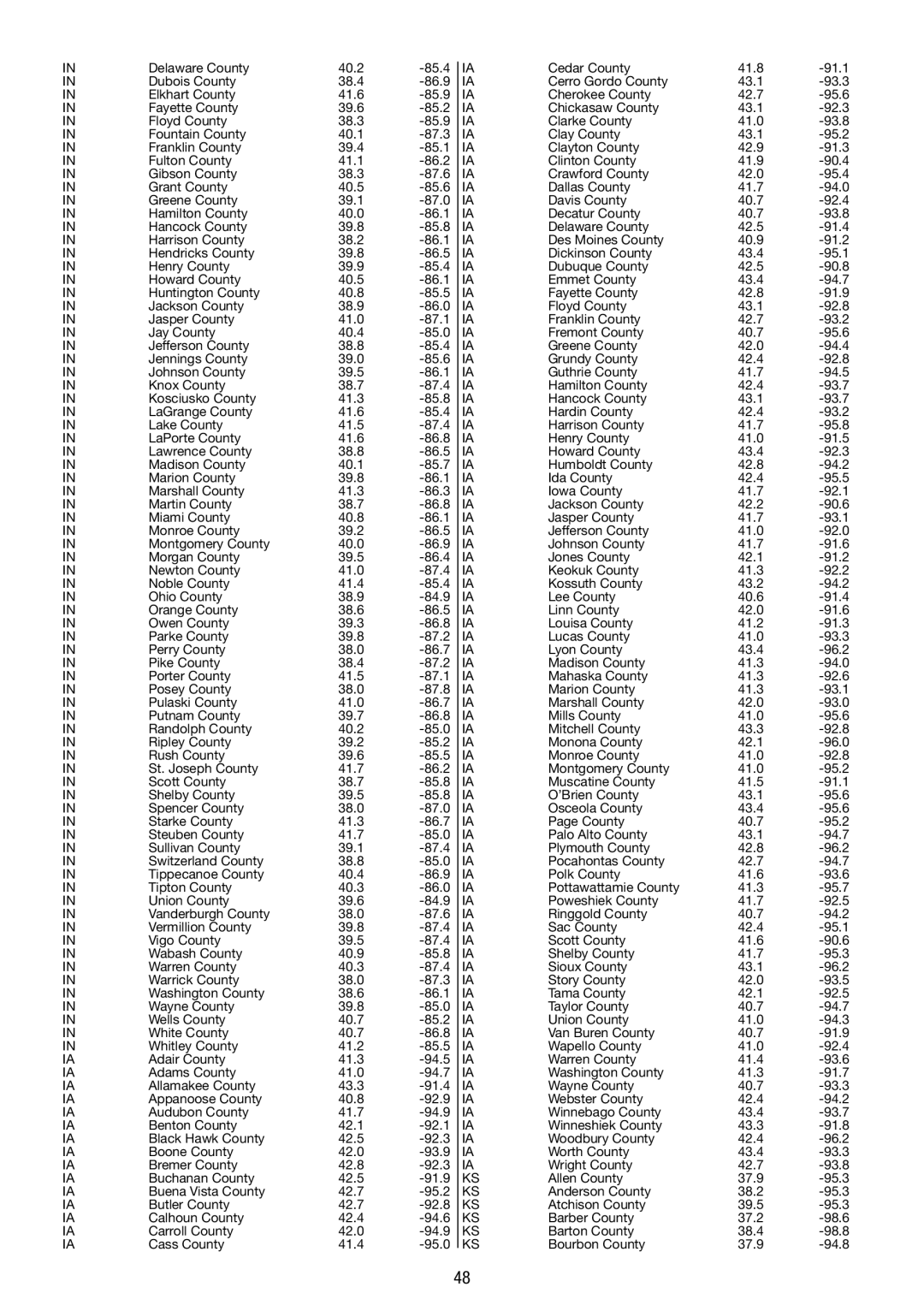
IN

Delaware County

40.2

-85.4


IA

Cedar County

41.8

-91.1

IN

Dubois County

38.4

-86.9


IA

Cerro Gordo County

43.1

-93.3

IN

Elkhart County

41.6

-85.9


IA

Cherokee County

42.7

-95.6

IN

Fayette County

39.6

-85.2


IA

Chickasaw County

43.1

-92.3

IN

Floyd County

38.3

-85.9


IA

Clarke County

41.0

-93.8

IN

Fountain County

40.1

-87.3


IA

Clay County

43.1

-95.2

IN

Franklin County

39.4

-85.1


IA

Clayton County

42.9

-91.3

IN

Fulton County

41.1

-86.2


IA

Clinton County

41.9

-90.4

IN

Gibson County

38.3

-87.6


IA

Crawford County

42.0

-95.4

IN

Grant County

40.5

-85.6


IA

Dallas County

41.7

-94.0

IN

Greene County

39.1

-87.0


IA

Davis County

40.7

-92.4

IN

Hamilton County

40.0

-86.1


IA

Decatur County

40.7

-93.8

IN

Hancock County

39.8

-85.8


IA

Delaware County

42.5

-91.4

IN

Harrison County

38.2

-86.1


IA

Des Moines County

40.9

-91.2

IN

Hendricks County

39.8

-86.5


IA

Dickinson County

43.4

-95.1

IN

Henry County

39.9

-85.4


IA

Dubuque County

42.5

-90.8

IN

Howard County

40.5

-86.1


IA

Emmet County

43.4

-94.7

IN

Huntington County

40.8

-85.5


IA

Fayette County

42.8

-91.9

IN

Jackson County

38.9

-86.0


IA

Floyd County

43.1

-92.8

IN

Jasper County

41.0

-87.1


IA

Franklin County

42.7

-93.2

IN

Jay County

40.4

-85.0


IA

Fremont County

40.7

-95.6

IN

Jefferson County

38.8

-85.4


IA

Greene County

42.0

-94.4

IN

Jennings County

39.0

-85.6


IA

Grundy County

42.4

-92.8

IN

Johnson County

39.5

-86.1


IA

Guthrie County

41.7

-94.5

IN

Knox County

38.7

-87.4


IA

Hamilton County

42.4

-93.7

IN

Kosciusko County

41.3

-85.8


IA

Hancock County

43.1

-93.7

IN

LaGrange County

41.6

-85.4


IA

Hardin County

42.4

-93.2

IN

Lake County

41.5

-87.4


IA

Harrison County

41.7

-95.8

IN

LaPorte County

41.6

-86.8


IA

Henry County

41.0

-91.5

IN

Lawrence County

38.8

-86.5


IA

Howard County

43.4

-92.3

IN

Madison County

40.1

-85.7


IA

Humboldt County

42.8

-94.2

IN

Marion County

39.8

-86.1


IA

Ida County

42.4

-95.5

IN

Marshall County

41.3

-86.3


IA

Iowa County

41.7

-92.1

IN

Martin County

38.7

-86.8


IA

Jackson County

42.2

-90.6

IN

Miami County

40.8

-86.1


IA

Jasper County

41.7

-93.1

IN

Monroe County

39.2

-86.5


IA

Jefferson County

41.0

-92.0

IN

Montgomery County

40.0

-86.9


IA

Johnson County

41.7

-91.6

IN

Morgan County

39.5

-86.4


IA

Jones County

42.1

-91.2

IN

Newton County

41.0

-87.4


IA

Keokuk County

41.3

-92.2

IN

Noble County

41.4

-85.4


IA

Kossuth County

43.2

-94.2

IN

Ohio County

38.9

-84.9


IA

Lee County

40.6

-91.4

IN

Orange County

38.6

-86.5


IA

Linn County

42.0

-91.6

IN

Owen County

39.3

-86.8


IA

Louisa County

41.2

-91.3

IN

Parke County

39.8

-87.2


IA

Lucas County

41.0

-93.3

IN

Perry County

38.0

-86.7


IA

Lyon County

43.4

-96.2

IN

Pike County

38.4

-87.2


IA

Madison County

41.3

-94.0

IN

Porter County

41.5

-87.1


IA

Mahaska County

41.3

-92.6

IN

Posey County

38.0

-87.8


IA

Marion County

41.3

-93.1

IN

Pulaski County

41.0

-86.7


IA

Marshall County

42.0

-93.0

IN

Putnam County

39.7

-86.8


IA

Mills County

41.0

-95.6

IN

Randolph County

40.2

-85.0


IA

Mitchell County

43.3

-92.8

IN

Ripley County

39.2

-85.2


IA

Monona County

42.1

-96.0

IN

Rush County

39.6

-85.5


IA

Monroe County

41.0

-92.8

IN

St. Joseph County

41.7

-86.2


IA

Montgomery County

41.0

-95.2

IN

Scott County

38.7

-85.8


IA

Muscatine County

41.5

-91.1

IN

Shelby County

39.5

-85.8


IA

O’Brien County

43.1

-95.6

IN

Spencer County

38.0

-87.0


IA

Osceola County

43.4

-95.6

IN

Starke County

41.3

-86.7


IA

Page County

40.7

-95.2

IN

Steuben County

41.7

-85.0


IA

Palo Alto County

43.1

-94.7

IN

Sullivan County

39.1

-87.4


IA

Plymouth County

42.8

-96.2

IN

Switzerland County

38.8

-85.0


IA

Pocahontas County

42.7

-94.7

IN

Tippecanoe County

40.4

-86.9


IA

Polk County

41.6

-93.6

IN

Tipton County

40.3

-86.0


IA

Pottawattamie County

41.3

-95.7

IN

Union County

39.6

-84.9


IA

Poweshiek County

41.7

-92.5

IN

Vanderburgh County

38.0

-87.6


IA

Ringgold County

40.7

-94.2

IN

Vermillion County

39.8

-87.4


IA

Sac County

42.4

-95.1

IN

Vigo County

39.5

-87.4


IA

Scott County

41.6

-90.6

IN

Wabash County

40.9

-85.8


IA

Shelby County

41.7

-95.3

IN

Warren County

40.3

-87.4


IA

Sioux County

43.1

-96.2

IN

Warrick County

38.0

-87.3


IA

Story County

42.0

-93.5

IN

Washington County

38.6

-86.1


IA

Tama County

42.1

-92.5

IN

Wayne County

39.8

-85.0


IA

Taylor County

40.7

-94.7

IN

Wells County

40.7

-85.2


IA

Union County

41.0

-94.3

IN

White County

40.7

-86.8


IA

Van Buren County

40.7

-91.9

IN

Whitley County

41.2

-85.5


IA

Wapello County

41.0

-92.4

IA

Adair County

41.3

-94.5


IA

Warren County

41.4

-93.6

IA

Adams County

41.0

-94.7


IA

Washington County

41.3

-91.7

IA

Allamakee County

43.3

-91.4


IA

Wayne County

40.7

-93.3

IA

Appanoose County

40.8

-92.9


IA

Webster County

42.4

-94.2

IA

Audubon County

41.7

-94.9


IA

Winnebago County

43.4

-93.7

IA

Benton County

42.1

-92.1


IA

Winneshiek County

43.3

-91.8

IA

Black Hawk County

42.5

-92.3


IA

Woodbury County

42.4

-96.2

IA

Boone County

42.0

-93.9


IA

Worth County

43.4

-93.3

IA

Bremer County

42.8

-92.3


IA

Wright County

42.7

-93.8

IA

Buchanan County

42.5

-91.9


KS

Allen County

37.9

-95.3

IA

Buena Vista County

42.7

-95.2


KS

Anderson County

38.2

-95.3

IA

Butler County

42.7

-92.8


KS

Atchison County

39.5

-95.3

IA

Calhoun County

42.4

-94.6


KS

Barber County

37.2

-98.6

IA

Carroll County

42.0

-94.9


KS

Barton County

38.4

-98.8

IA

Cass County

41.4

-95.0


KS

Bourbon County

37.9

-94.8


48

Page 48
Image 48
La Crosse Technology WS 550 US operating instructions

WS 550 US specifications

The La Crosse Technology WS 550 US is an advanced weather station designed for both amateur meteorologists and weather enthusiasts. It seamlessly combines cutting-edge technology with user-friendly features, capturing comprehensive meteorological data for intuitive analysis and real-time monitoring.

At the heart of the WS 550 US is its wireless sensor technology. This weather station includes an outdoor sensor that accurately measures temperature, humidity, wind speed, wind direction, and rainfall. The wireless connection allows for a convenient setup, as users can place the sensor up to 300 feet away from the display console. This flexibility ensures optimal placement for accurate readings while maintaining easy access to the display.

One of the standout features of the WS 550 US is its large, easy-to-read LCD screen, which displays a wealth of information at a glance. The console shows indoor and outdoor temperatures, humidity levels, wind speeds, and weather forecasts based on barometric pressure changes. The multi-functional display provides a clear summary of current conditions, making it easier for users to prepare for changing weather patterns.

In addition to real-time data, the WS 550 US also boasts a unique alarm system for severe weather conditions. Users can set up personalized alerts for high and low temperature thresholds, humidity levels, and rainfall amounts. This proactive feature gives users peace of mind, allowing them to respond to potential weather hazards quickly.

The WS 550 US integrates advanced forecasting technology, utilizing a built-in barometer to predict weather changes up to 12-24 hours in advance. The included historical data feature allows users to review past weather patterns, granting insights into local climatic trends and forecasting.

Another admirable aspect of this weather station is its compatibility with La Crosse's mobile app, enabling users to access their weather data remotely. This feature is particularly appealing in today’s digital age, making monitoring weather conditions possible from smartphones and tablets.

With its combination of advanced technology and user-oriented features, the La Crosse Technology WS 550 US provides reliable and accurate weather data, appealing to anyone interested in understanding the elements that shape our environment. Whether preparing for a gardening project, planning outdoor activities, or simply staying informed, this weather station stands out as a versatile tool in any setting.