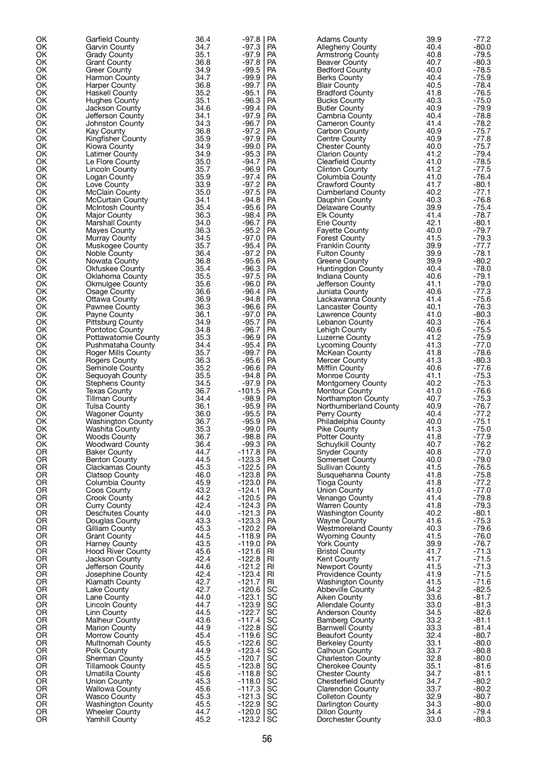
OK

Garfield County

36.4

-97.8


PA

Adams County

39.9

-77.2

OK

Garvin County

34.7

-97.3


PA

Allegheny County

40.4

-80.0

OK

Grady County

35.1

-97.9


PA

Armstrong County

40.8

-79.5

OK

Grant County

36.8

-97.8


PA

Beaver County

40.7

-80.3

OK

Greer County

34.9

-99.5


PA

Bedford County

40.0

-78.5

OK

Harmon County

34.7

-99.9


PA

Berks County

40.4

-75.9

OK

Harper County

36.8

-99.7


PA

Blair County

40.5

-78.4

OK

Haskell County

35.2

-95.1


PA

Bradford County

41.8

-76.5

OK

Hughes County

35.1

-96.3


PA

Bucks County

40.3

-75.0

OK

Jackson County

34.6

-99.4


PA

Butler County

40.9

-79.9

OK

Jefferson County

34.1

-97.9


PA

Cambria County

40.4

-78.8

OK

Johnston County

34.3

-96.7


PA

Cameron County

41.4

-78.2

OK

Kay County

36.8

-97.2


PA

Carbon County

40.9

-75.7

OK

Kingfisher County

35.9

-97.9


PA

Centre County

40.9

-77.8

OK

Kiowa County

34.9

-99.0


PA

Chester County

40.0

-75.7

OK

Latimer County

34.9

-95.3


PA

Clarion County

41.2

-79.4

OK

Le Flore County

35.0

-94.7


PA

Clearfield County

41.0

-78.5

OK

Lincoln County

35.7

-96.9


PA

Clinton County

41.2

-77.5

OK

Logan County

35.9

-97.4


PA

Columbia County

41.0

-76.4

OK

Love County

33.9

-97.2


PA

Crawford County

41.7

-80.1

OK

McClain County

35.0

-97.5


PA

Cumberland County

40.2

-77.1

OK

McCurtain County

34.1

-94.8


PA

Dauphin County

40.3

-76.8

OK

McIntosh County

35.4

-95.6


PA

Delaware County

39.9

-75.4

OK

Major County

36.3

-98.4


PA

Elk County

41.4

-78.7

OK

Marshall County

34.0

-96.7


PA

Erie County

42.1

-80.1

OK

Mayes County

36.3

-95.2


PA

Fayette County

40.0

-79.7

OK

Murray County

34.5

-97.0


PA

Forest County

41.5

-79.3

OK

Muskogee County

35.7

-95.4


PA

Franklin County

39.9

-77.7

OK

Noble County

36.4

-97.2


PA

Fulton County

39.9

-78.1

OK

Nowata County

36.8

-95.6


PA

Greene County

39.9

-80.2

OK

Okfuskee County

35.4

-96.3


PA

Huntingdon County

40.4

-78.0

OK

Oklahoma County

35.5

-97.5


PA

Indiana County

40.6

-79.1

OK

Okmulgee County

35.6

-96.0


PA

Jefferson County

41.1

-79.0

OK

Osage County

36.6

-96.4


PA

Juniata County

40.6

-77.3

OK

Ottawa County

36.9

-94.8


PA

Lackawanna County

41.4

-75.6

OK

Pawnee County

36.3

-96.6


PA

Lancaster County

40.1

-76.3

OK

Payne County

36.1

-97.0


PA

Lawrence County

41.0

-80.3

OK

Pittsburg County

34.9

-95.7


PA

Lebanon County

40.3

-76.4

OK

Pontotoc County

34.8

-96.7


PA

Lehigh County

40.6

-75.5

OK

Pottawatomie County

35.3

-96.9


PA

Luzerne County

41.2

-75.9

OK

Pushmataha County

34.4

-95.4


PA

Lycoming County

41.3

-77.0

OK

Roger Mills County

35.7

-99.7


PA

McKean County

41.8

-78.6

OK

Rogers County

36.3

-95.6


PA

Mercer County

41.3

-80.3

OK

Seminole County

35.2

-96.6


PA

Mifflin County

40.6

-77.6

OK

Sequoyah County

35.5

-94.8


PA

Monroe County

41.1

-75.3

OK

Stephens County

34.5

-97.9


PA

Montgomery County

40.2

-75.3

OK

Texas County

36.7

-101.5


PA

Montour County

41.0

-76.6

OK

Tillman County

34.4

-98.9


PA

Northampton County

40.7

-75.3

OK

Tulsa County

36.1

-95.9


PA

Northumberland County

40.9

-76.7

OK

Wagoner County

36.0

-95.5


PA

Perry County

40.4

-77.2

OK

Washington County

36.7

-95.9


PA

Philadelphia County

40.0

-75.1

OK

Washita County

35.3

-99.0


PA

Pike County

41.3

-75.0

OK

Woods County

36.7

-98.8


PA

Potter County

41.8

-77.9

OK

Woodward County

36.4

-99.3


PA

Schuylkill County

40.7

-76.2

OR

Baker County

44.7

-117.8


PA

Snyder County

40.8

-77.0

OR

Benton County

44.5

-123.3


PA

Somerset County

40.0

-79.0

OR

Clackamas County

45.3

-122.5


PA

Sullivan County

41.5

-76.5

OR

Clatsop County

46.0

-123.8


PA

Susquehanna County

41.8

-75.8

OR

Columbia County

45.9

-123.0


PA

Tioga County

41.8

-77.2

OR

Coos County

43.2

-124.1


PA

Union County

41.0

-77.0

OR

Crook County

44.2

-120.5


PA

Venango County

41.4

-79.8

OR

Curry County

42.4

-124.3


PA

Warren County

41.8

-79.3

OR

Deschutes County

44.0

-121.3


PA

Washington County

40.2

-80.1

OR

Douglas County

43.3

-123.3


PA

Wayne County

41.6

-75.3

OR

Gilliam County

45.3

-120.2


PA

Westmoreland County

40.3

-79.6

OR

Grant County

44.5

-118.9


PA

Wyoming County

41.5

-76.0

OR

Harney County

43.5

-119.0


PA

York County

39.9

-76.7

OR

Hood River County

45.6

-121.6


RI

Bristol County

41.7

-71.3

OR

Jackson County

42.4

-122.8


RI

Kent County

41.7

-71.5

OR

Jefferson County

44.6

-121.2


RI

Newport County

41.5

-71.3

OR

Josephine County

42.4

-123.4


RI

Providence County

41.9

-71.5

OR

Klamath County

42.7

-121.7


RI

Washington County

41.5

-71.6

OR

Lake County

42.7

-120.6


SC

Abbeville County

34.2

-82.5

OR

Lane County

44.0

-123.1


SC

Aiken County

33.6

-81.7

OR

Lincoln County

44.7

-123.9


SC

Allendale County

33.0

-81.3

OR

Linn County

44.5

-122.7


SC

Anderson County

34.5

-82.6

OR

Malheur County

43.6

-117.4


SC

Bamberg County

33.2

-81.1

OR

Marion County

44.9

-122.8


SC

Barnwell County

33.3

-81.4

OR

Morrow County

45.4

-119.6


SC

Beaufort County

32.4

-80.7

OR

Multnomah County

45.5

-122.6


SC

Berkeley County

33.1

-80.0

OR

Polk County

44.9

-123.4


SC

Calhoun County

33.7

-80.8

OR

Sherman County

45.5

-120.7


SC

Charleston County

32.8

-80.0

OR

Tillamook County

45.5

-123.8


SC

Cherokee County

35.1

-81.6

OR

Umatilla County

45.6

-118.8


SC

Chester County

34.7

-81.1

OR

Union County

45.3

-118.0


SC

Chesterfield County

34.7

-80.2

OR

Wallowa County

45.6

-117.3


SC

Clarendon County

33.7

-80.2

OR

Wasco County

45.3

-121.3


SC

Colleton County

32.9

-80.7

OR

Washington County

45.5

-122.9


SC

Darlington County

34.3

-80.0

OR

Wheeler County

44.7

-120.0


SC

Dillon County

34.4

-79.4

OR

Yamhill County

45.2

-123.2


SC

Dorchester County

33.0

-80.3


56

Page 56
Image 56
La Crosse Technology WS 550 US operating instructions

WS 550 US specifications

The La Crosse Technology WS 550 US is an advanced weather station designed for both amateur meteorologists and weather enthusiasts. It seamlessly combines cutting-edge technology with user-friendly features, capturing comprehensive meteorological data for intuitive analysis and real-time monitoring.

At the heart of the WS 550 US is its wireless sensor technology. This weather station includes an outdoor sensor that accurately measures temperature, humidity, wind speed, wind direction, and rainfall. The wireless connection allows for a convenient setup, as users can place the sensor up to 300 feet away from the display console. This flexibility ensures optimal placement for accurate readings while maintaining easy access to the display.

One of the standout features of the WS 550 US is its large, easy-to-read LCD screen, which displays a wealth of information at a glance. The console shows indoor and outdoor temperatures, humidity levels, wind speeds, and weather forecasts based on barometric pressure changes. The multi-functional display provides a clear summary of current conditions, making it easier for users to prepare for changing weather patterns.

In addition to real-time data, the WS 550 US also boasts a unique alarm system for severe weather conditions. Users can set up personalized alerts for high and low temperature thresholds, humidity levels, and rainfall amounts. This proactive feature gives users peace of mind, allowing them to respond to potential weather hazards quickly.

The WS 550 US integrates advanced forecasting technology, utilizing a built-in barometer to predict weather changes up to 12-24 hours in advance. The included historical data feature allows users to review past weather patterns, granting insights into local climatic trends and forecasting.

Another admirable aspect of this weather station is its compatibility with La Crosse's mobile app, enabling users to access their weather data remotely. This feature is particularly appealing in today’s digital age, making monitoring weather conditions possible from smartphones and tablets.

With its combination of advanced technology and user-oriented features, the La Crosse Technology WS 550 US provides reliable and accurate weather data, appealing to anyone interested in understanding the elements that shape our environment. Whether preparing for a gardening project, planning outdoor activities, or simply staying informed, this weather station stands out as a versatile tool in any setting.