AS740
Important Health Information and Safety Precautions
Use the correct external power source
Handle battery packs carefully
Take extra precautions
Safety Precautions for Direct Sunlight
Prevention of Hearing Loss Safety in Aircraft
Safety Precautions for RF Exposure
Hearing Aids
Connecting to Networks and Devices
Placing and Receiving Calls
104
121
160
206
182
198
216
232
284
259
282
293
Important Customer Information
Important Information
Technical Details
Interface
Designator Description Standard
Basic Air
Network
Vehicle-Mounted External Antenna Optional, if available
Part 15.19 statement
Part 15.21 statement
Part 15.105 statement
Phone Overview
Front View
Basics
Rear View
Accessory Camera Key Charger Port
Left Side Right Side
Slide Out Qwerty Keyboard
Basics
Installing the Battery and microSD Card
Installing the battery
Removing the battery
To unmount the microSD card
Inserting a microSD card
Removing the microSD card
Touch Unmount SD card
Battery temperature protection
Battery charge level
Charging the Phone
Turning the phone on
Turning the Phone On and Off
Charging with USB
Turning the phone off
Press the Power/Lock Key
To unlock the phone
To turn the phone sounds off
Getting started with your AndroidTM phone
Your Google account
Phone’s Status Icons
Status icons
Notification icons
Call in progress
Getting to Know the Home Screen
Android Home LG Home
Selecting a Home Screen Theme
To return to the Home screen
Quick Keys
To view other Home screen panes
Touchscreen
LG Home screen
Basics
Qwerty Keyboard
Using the Qwerty keyboard
Onscreen Keyboard
Entering Text
Using the onscreen keyboard
Editing text
To cut or copy and paste all the text
Touch Cut all or Copy all
To cut or copy and paste some of the text
Touch Select text
Applications How to View, Open and Switch
Overview
Opening and Closing the Launch screen
Customizing the LG Home Launch Screen
Opening multiple applications
Opening and Switching Applications
Opening an application
Press the Home Key
Setting Keyboard Shortcuts to Applications
Switching between multiple applications
Adding application icons to the Home screen
Working with Menus
Options menus
Managing Notifications
Context menus
To clear all notifications
To open the Notifications panel
To respond to a notification
To close the notifications panel
Phone and Web search using text entry
Searching Your Phone and the Web
Touch the Search Key
Basics
Web search using voice command
Setting a Lock Pattern
Locking the Screen
Customizing the Home Screen
To add an item to the Home screen
To change the Home screen wallpaper
To move an item on the Home screen
To remove an item from the Home screen
Touch Gallery, Live wallpapers, or Wallpapers
Connecting Quickly With Your Contacts
To rename a folder
Optimizing Battery Life
Tips to extend the life of your battery
To check the battery charge level
To monitor and control what uses the battery
Connecting to Mobile Networks
To disable data when roaming
Touch Settings Wireless & networks Mobile networks
To limit your data connection to 2G networks
Connecting to Wi-Fi Networks
To turn Wi-Fi on and connect to a Wi-Fi network
Touch Settings Wireless & networks Wi-Fi settings
To receive notifications when open networks are in range
To add a Wi-Fi network
To forget a Wi-Fi network
Touch Forget network
Touch Settings Wireless & networks
Connecting to Bluetooth Devices
To turn Bluetooth on or off
Bluetooth QD ID B016383
To change your phone’s Bluetooth name
To pair your phone with a Bluetooth device
Touch Settings Wireless & networks Bluetooth settings
To connect to a Bluetooth device
To configure the Bluetooth features you want to use
To disconnect from a Bluetooth device
Dial Up Networking
To unpair a Bluetooth device
Touch Enable
Before you proceed
Connecting to a Computer via USB
To connect your phone to a computer via USB
To disconnect your phone from the computer
Touch Settings SD card & phone storage Touch Format SD card
To safely remove the microSD card from your phone
To format a microSD card
Connecting to Virtual Private Networks
To add a VPN
To connect to a VPN
To disconnect from a VPN
To install a secure certificate from the microSD card
Touch Settings Location & security
Working With Secure Certificates
Placing and Ending Calls
To open the Phone application
To place a call by dialing
To end a call
Answering or Rejecting Calls
Airplane mode to disable wireless communication
Touch Airplane mode
To answer a call
Working with the Call Log
To decline a call and divert it to voicemail
To open the Call log
To take other actions on a Call log entry
To dial a number in the Call log
To add an entry’s number to your Contacts
To clear the Call log
To call a favorite contact
Calling Your Contacts
To call a contact
Favorites tab
To place a call by speaking
Dialing by Voice
Options During a Call
To mute the microphone during a call
Managing Multiple Calls
To switch between a Bluetooth headset and the phone
To switch between current calls
To turn the speakerphone on or off
To set up a conference call
Listening to Your Voicemail
To end a conference call and disconnect all callers
To listen to your voicemail
Touch the Voicemail Key
To set up your voicemail
To access your voicemail from your wireless device
Touch Dialpad
Using Your Contacts
To open your Contacts application
To open a list of your favorite contacts
To view details about a contact
Adding Contacts
To add a new contact
Press the Menu Key and touch New contact
Importing, Exporting, and Sharing Contacts
To import contacts from your microSD card
To export contacts to your microSD card
To share a contact
To add a contact to your favorites
Adding a Contact to Your Favorites
Searching for a Contact
To remove a contact from your favorites list
Editing Contact Details
To edit contact details
To set a ringtone for a contact
To change a contact’s default phone number
To divert calls from a contact to your voicemail
Touch the Back Key
Communicating with Your Contacts
To delete a contact
Press the Menu Key and touch Delete contact
To connect by using Quick Contact for AndroidTM
To communicate with a contact
To call a contact’s default number
To change which groups are displayed
Selecting which Contacts are Displayed
To set whether contacts without phone numbers are displayed
Press the Menu Key and touch Display options
Joining Contacts
To join contacts
Press the Menu Key and touch Edit contact
Separating Contact Information
To separate contact information
Adding and Removing Accounts
To add an account
Touch the account you want to add
To remove an account
Touch the Remove account button
Configuring Account Sync and Display Options
To configure general sync settings
To sync information manually
To change an account’s sync settings
Gmail is Different
Opening Gmail and Your Inbox
To open the Gmail application
To open your Inbox when Gmail is running
Touch More Back to Inbox
To switch accounts
Reading Your Messages
To read a message
To reread a message
Composing and Sending a Message
To compose and send a message
Replying to or Forwarding a Message
To reply to or forward a message
Touch Reply, Reply to all, or Forward
Working with Conversations in Batches
To label a batch of conversations at once
Labeling a Conversation
To label a conversation
To change a conversation’s labels
Starring a Message
To star a message
To unstar a message
Viewing Conversations by Label
To report a conversation as spam
Reporting Spam
Searching for Messages
Menu Key and touch Report spam
Archiving Conversations
To Archive a conversation
Press the Menu Key and touch Settings Labels
Synchronizing Your Messages
To select which conversations to synchronize
Press the Menu Key and touch Settings Signature
Appending a Signature to Your Messages
To set how many days of conversations to synchronize
Changing Gmail Settings
General Settings
Notification settings
Viewing Your Calendar and Events
To open your Calendar application
To change your Calendar view
To switch to Agenda view
Working in Agenda View
To learn more about events in Agenda view
To learn more about events in Day view
To switch to Day view
Working in Day View
To add an event in Day view
To learn more about events in Week view
To switch to Week view
Working in Week View
To add an event in Week view
To view more information about events in Month view
To switch to Month view
Working in Month View
To add an event in Month view
Viewing Event Details
To view information about an event
Creating an Event
To create an event
Editing or Deleting an Event
To edit an event
To delete an event
Setting an Event Reminder
To set an event reminder
To delete an event reminder
Responding to an Event Reminder
To respond to an event reminder
Displaying and Synchronizing Calendars
To show or hide calendars
To set which calenders are synchronized on your phone
Changing Calendar Settings
Signing in and Opening your Friends List
To open Google Talk and sign
To return to your friends list
To sign out of Google Talk
Chatting with Friends
To chat with a friend
To switch between active chats
To accept an invitation to chat
To invite a friend to join a group chat
To chat on or off the record
To end a chat
Changing and Monitoring Online Status
To change your online status
Managing Your Friends List
To change your status message
To change your picture
To view a list of pending invitations to friends
To add a friend to your Friends list
To view and accept an invitation to become a friend
To view all friends or only those most popular with you
To add a friend to the ‘Most popular’ group
To block a friend
Changing Google Talk Settings
To configure notifications for new Google Talk messages
To show or hide the mobile indicator to friends
To set whether you sign into Google Talk automatically
Checkmark or uncheck Automatically sign
Opening Email and the Accounts Screen
To open the Email application
Accounts screen
To open your Combined Inbox
Accounts Screen
Page
Reading Your Messages
To delete a message
Responding to a Message
To mark a message as unread
Press the Menu Key and touch Reply, Reply all, or Forward
Starring Messages
To view your starred messages
Composing and Sending Email
Working with Account Folders
To view an account’s folders
Adding and Editing Email Accounts
To add an email account
Press the Menu Key and touch Add account
Page
Email account settings
Changing Email Account Settings
To change an account’s settings
To delete an email account
Page
Incoming server settings
Security
Settings for POP3 accounts
Port
Type
Outgoing server settings
Smtp
Opening Messaging
To open Messaging
To delete a message thread from the Messaging window
Exchanging Messages
To send a text message
To create and send a multimedia message
Messaging
To respond to messages you receive
To view details about a message
Changing Messaging Settings
Storage settings
Text message SMS settings
Multimedia message MMS settings
Opening Browser
To open Browser
To go to a webpage
To refresh the current
To stop opening a
To set your home
Navigating within a webpage
To get more information about the current
To scroll a webpage
To zoom in or out on a webpage
To quickly zoom into a section of a webpage
To find text on a webpage
Press the Menu Key and touch More Find on
To go back and forth among the pages you’ve opened
Navigating Among Webpages
To open a link
To view your Browser history
To view your most frequently visited pages
To follow shortcuts for links, phone numbers, and addresses
Touch the Most visited tab
To open a new Browser window
To switch Browser windows
Working with Multiple Browser Windows
To close a Browser window
Downloading Files
To allow installing applications from the web or email
Touch Settings Applications
To download a file
To cancel a download
To view the files you’ve downloaded
To open a bookmark
Working with Bookmarks
To bookmark a webpage
To edit a bookmark
To delete a bookmark
To share a bookmark
To add a bookmark shortcut to the Home screen
Touch Shortcuts Touch Bookmarks
Changing Browser Settings
Content settings
Privacy settings
Security settings
Advanced settings
To use location services with Google Maps
Touch Settings Privacy
Opening Google Maps and Viewing Your Location
To zoom in and out of a map
To open Google Maps and view your location
To move the map
Press the Menu Key and touch My location
Changing Map Layers
To get an address and additional information for a location
To clear the map
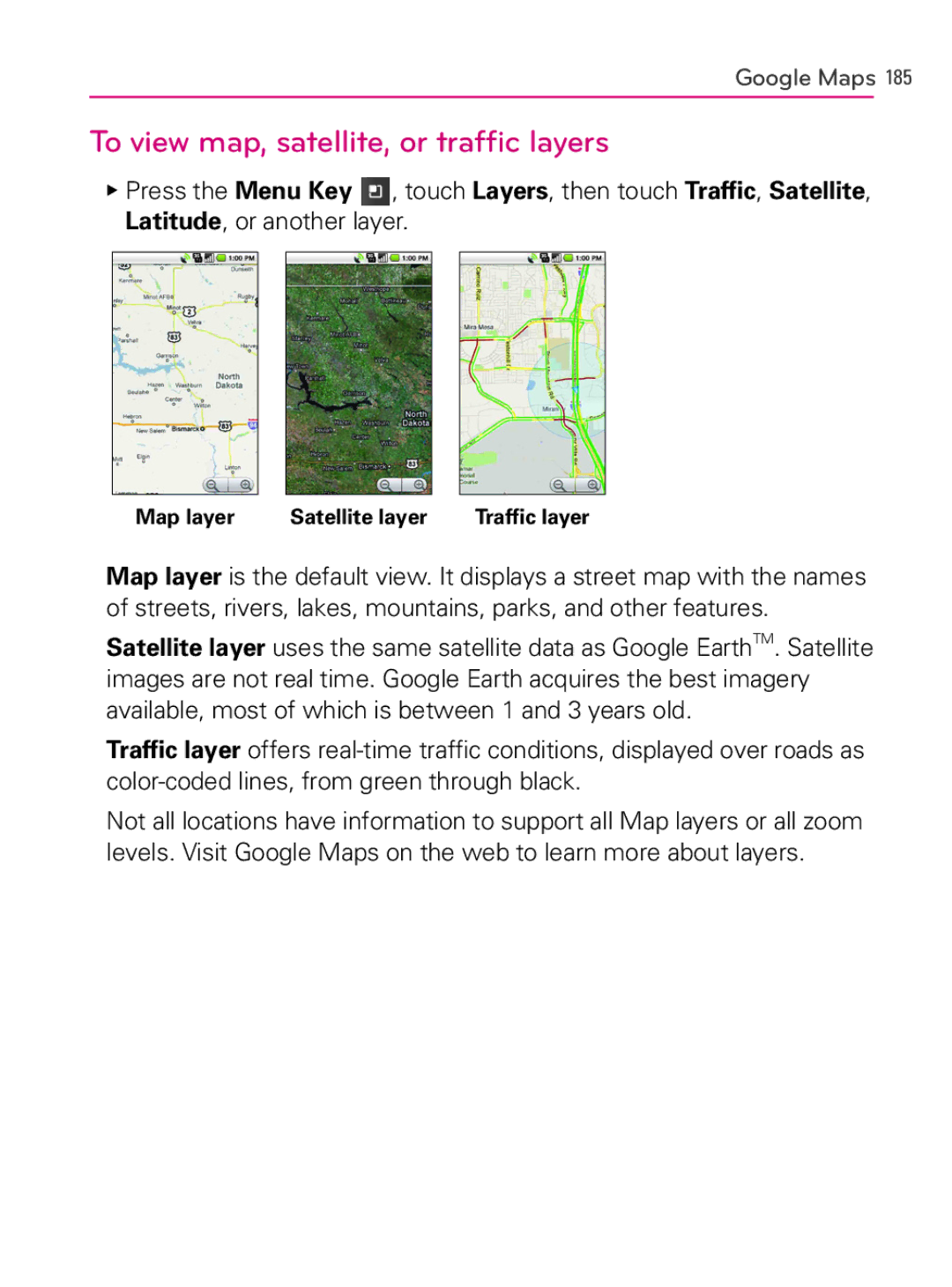
To view map, satellite, or traffic layers
Searching For Locations and Places
To search for a location
Getting Directions
To get directions
Navigating with Spoken, Turn-by-turn Directions
To navigate with turn-by-turn directions
Compass indicates north Your current location and direction
To return to Navigation View
To change views of your route
To search for locations along your route
To preview your route
To view traffic conditions on your route
To exit navigation
Finding Your Friends with Google LatitudeTM
To get an alternate route to your destination
Press the Menu Key and touch Exit Navigation
To join Latitude
To open Latitude
To invite friends to share their locations
To respond to an invitation
To view your friends’ locations
To connect with and manage connections with your friends
To control what you share
Opening Camera and Taking Pictures
To open the Camera application
To take a picture
To take pictures with digital zoom
To shoot a video
Reviewing Your Pictures
To review your pictures
Touch the Picture review icon
Use the Album View switch
Reviewing Your Videos
Changing Camera Settings
To change Camera settings
Camera settings
Camcorder settings
Opening Gallery and viewing Your Albums
To open Gallery and view your albums
To open an album and view its contents
Working with Albums
To change how the contents of an album are displayed
To Work with Batches of Pictures or Videos
To share an album
To delete an album
Working with Pictures
To get details about an album
To view and browse pictures
To watch a slideshow of your pictures
To rotate a picture
Touch Rotate Left or Rotate Right
To crop a picture
Touch Set as
To share a picture
To get details about a picture
To view the location of a picture in Google MapsTM
Touch Details
Working with Videos
To delete a picture
To play videos
To share a video
To delete a video
Touch Confirm Delete
Opening YouTube and Watching Videos
To open the YouTube application
To watch and interact with YouTube videos
To search for videos
To share your videos on YouTube
Touch the Recording Key
Touch Upload
Transferring Music Files to Your Phone
To copy music files onto the phone’s microSD card
Opening Music and Working with Your Library
To open Music and view your music library
To search for music in your library
To delete a song from the microSD card
Playing Music
To play music
To control playback volume
To control playback
To play your tracks in a party shuffle
To use a song as a ringtone
To add a song to a playlist
Working with Playlists
To create a playlist
Touch Add to playlist
To remove a song from a playlist
To rename or delete a playlist
To create playlists on your computer
Viewing the Date, Time, and Other Information
To open the Clock application
To play a slideshow
Setting Alarms
To set an alarm
To dim the Clock display
Clock
Changing Clock Alarm Settings
Using Car Home
Using the Calculator
To open and use the Calculator
To clear your history of operations
Opening Android Market and Finding Applications
To open Android Market application
To get help with Android Market
To browse for applications
To return to Android Market home screen
To open a screen with details about an application
To search for applications
Search Key
Downloading and Installing Applications
To download and install an application
To create a Google Checkout account
Managing Your Downloads
To uninstall an application
Touch Uninstall
To view your downloaded applications
To request a refund for an application
To set whether you’re notified about updated applications
Touch Uninstall and refund
Press the Menu Key and touch Notifications
To rate an application
To flag inappropriate applications
Opening Settings
Wireless & networks
To open Settings
Wi-Fi settings screen
Advanced Wi-Fi settings screen
Bluetooth settings screen
VPN settings screen
Mobile networks settings screen
Call settings
Call settings screen
Other call settings
Sound & display settings screen
Sound & display
Location & security
Settings
Applications settings screen
Applications
Application Info screen
Development screen
Accounts & sync settings screen
Accounts & sync
Privacy
Account screen
SD card & phone storage
SD card & phone storage screen
Language & keyboard
Search settings screen
Search
Language & keyboard screen
Android Keyboard settings screen
Device Keyboard settings screen
Accessibility
Text-to-speech settings screen
Text-to-speech
Date & time
About phone
About phone screen
Settings
TIA Safety Information
Exposure to Radio Frequency Signal
Antenna Care
Driving
Phone Operation
Tips on Efficient Operation
Electronic Devices
Other Medical Devices
Persons with pacemakers
Hearing Aids
Health Care Facilities
Potentially Explosive Atmosphere
Aircraft
Blasting Areas
For Vehicles Equipped with an Air Bag
Safety Information
Charger and Adapter Safety
Battery Information and Care
Explosion, Shock, and Fire Hazards
General Notice
Avoiding hearing damage
Using headsets safely
FDA Consumer Update
Using your phone safely
Do wireless phones pose a health hazard?
Safety
What kinds of phones are the subject of this update?
What are the results of the research done already?
Safety
Safety
What about children using wireless phones?
Where can I find additional information?
Driver Safety Tips
Safety
Consumer Information on SAR
Safety
Safety
Safety
Safety
Wireless
Power
Battery
Physical
Camera
Platform
Category Sub Question Answer
Is it possible to Inbox is automatically
284 FAQ
FAQ
286 FAQ
Key
Settings
Category
Question Answer Category
Manage applications
Ringtone
Touch Settings Privacy
FAQUpdated
Contacts
Can I import contacts to my LG AS740?
Touch Accounts & sync
How can I separate the grouped contacts?
How can I sync contacts?
How can I check that my data is synchronizing?
Email Information
Unable to access your Email on the AS740?
Why can’t I open email attachments?
File types supported by the Email application
Other Email-Related Issues
Why can’t I connect to the Mail Server?
Why do my Exchange emails only go back a few days?
Supported Email Features
EASExchange
AcitveSync
How do I sync Socialite with Facebook?
Accounts & sync
You can sync data only about friends already in Contacts
What this Warranty Covers
What LG will do
HOW to GET Warranty Service
Tel -800-793-8896 or Fax
Page