For extensive astronomical observing, the telescope is best mounted in the polar configuration. In polar alignment the telescope is oriented so that the horizontal and vertical axes of the telescope align with the celestial coordinate system (see Fig. 11).
To polar align either ETX model you must understand how and where to locate celestial objects as they move across the sky. This section introduces the terminology of polar-aligned astronomy, and includes instructions for finding the celestial pole and for following objects in the night sky using Declination and Right Ascension.
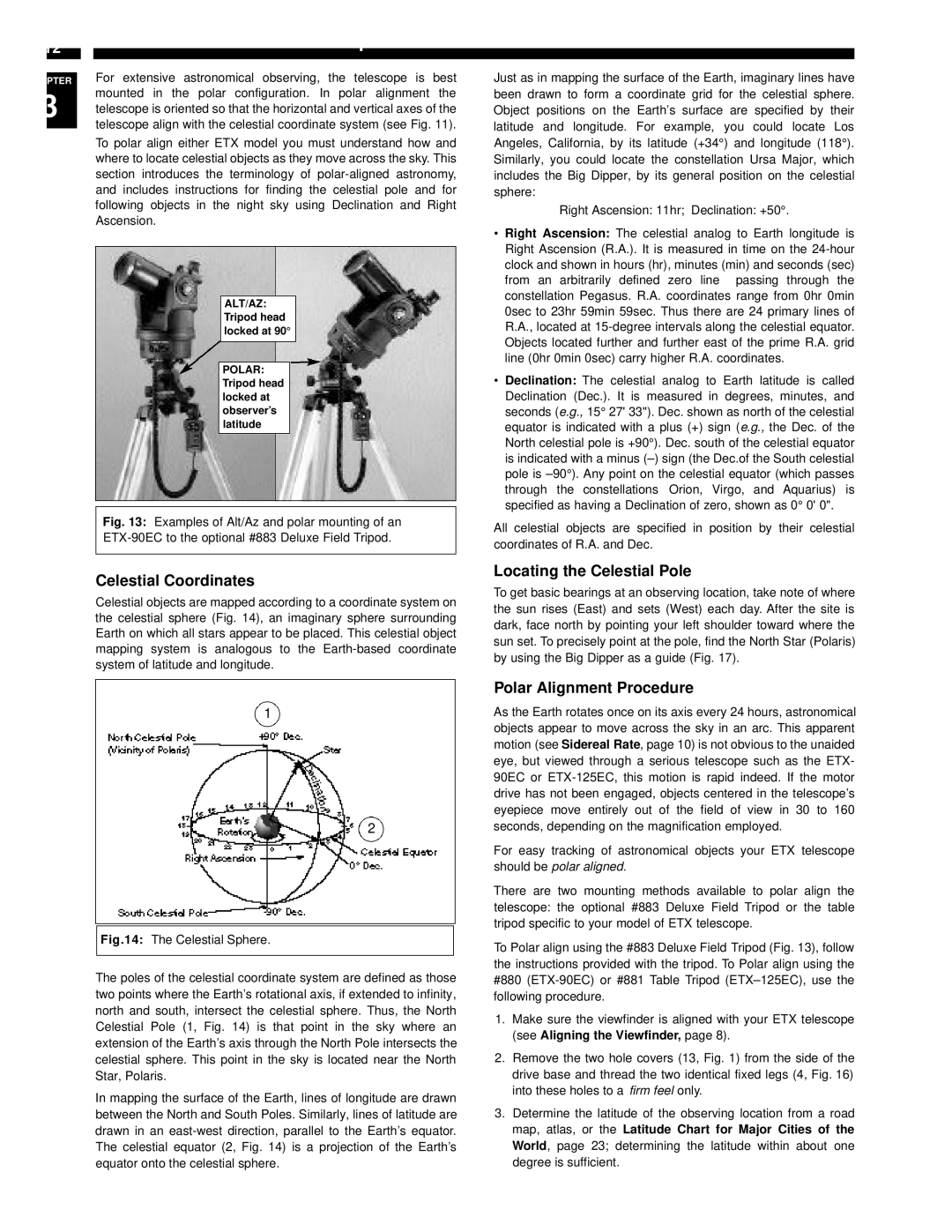
ALT/AZ: Tripod head locked at 90°
POLAR: Tripod head locked at observer’s latitude
Fig. 13: Examples of Alt/Az and polar mounting of an ETX-90EC to the optional #883 Deluxe Field Tripod.
Celestial Coordinates
Celestial objects are mapped according to a coordinate system on the celestial sphere (Fig. 14), an imaginary sphere surrounding Earth on which all stars appear to be placed. This celestial object mapping system is analogous to the Earth-based coordinate system of latitude and longitude.
1
2
Fig.14: The Celestial Sphere.
The poles of the celestial coordinate system are defined as those two points where the Earth’s rotational axis, if extended to infinity, north and south, intersect the celestial sphere. Thus, the North Celestial Pole (1, Fig. 14) is that point in the sky where an extension of the Earth’s axis through the North Pole intersects the celestial sphere. This point in the sky is located near the North Star, Polaris.
In mapping the surface of the Earth, lines of longitude are drawn between the North and South Poles. Similarly, lines of latitude are drawn in an east-west direction, parallel to the Earth’s equator. The celestial equator (2, Fig. 14) is a projection of the Earth’s equator onto the celestial sphere.
Just as in mapping the surface of the Earth, imaginary lines have been drawn to form a coordinate grid for the celestial sphere. Object positions on the Earth’s surface are specified by their latitude and longitude. For example, you could locate Los Angeles, California, by its latitude (+34°) and longitude (118°). Similarly, you could locate the constellation Ursa Major, which includes the Big Dipper, by its general position on the celestial sphere:
Right Ascension: 11hr; Declination: +50°.
•Right Ascension: The celestial analog to Earth longitude is Right Ascension (R.A.). It is measured in time on the 24-hour clock and shown in hours (hr), minutes (min) and seconds (sec) from an arbitrarily defined zero line passing through the constellation Pegasus. R.A. coordinates range from 0hr 0min 0sec to 23hr 59min 59sec. Thus there are 24 primary lines of R.A., located at 15-degree intervals along the celestial equator. Objects located further and further east of the prime R.A. grid line (0hr 0min 0sec) carry higher R.A. coordinates.
•Declination: The celestial analog to Earth latitude is called Declination (Dec.). It is measured in degrees, minutes, and seconds (e.g., 15° 27' 33"). Dec. shown as north of the celestial equator is indicated with a plus (+) sign (e.g., the Dec. of the North celestial pole is +90°). Dec. south of the celestial equator is indicated with a minus (–) sign (the Dec.of the South celestial pole is –90°). Any point on the celestial equator (which passes through the constellations Orion, Virgo, and Aquarius) is specified as having a Declination of zero, shown as 0° 0' 0".
All celestial objects are specified in position by their celestial coordinates of R.A. and Dec.
Locating the Celestial Pole
To get basic bearings at an observing location, take note of where the sun rises (East) and sets (West) each day. After the site is dark, face north by pointing your left shoulder toward where the sun set. To precisely point at the pole, find the North Star (Polaris) by using the Big Dipper as a guide (Fig. 17).
Polar Alignment Procedure
As the Earth rotates once on its axis every 24 hours, astronomical objects appear to move across the sky in an arc. This apparent motion (see Sidereal Rate, page 10) is not obvious to the unaided eye, but viewed through a serious telescope such as the ETX- 90EC or ETX-125EC, this motion is rapid indeed. If the motor drive has not been engaged, objects centered in the telescope’s eyepiece move entirely out of the field of view in 30 to 160 seconds, depending on the magnification employed.
For easy tracking of astronomical objects your ETX telescope should be polar aligned.
There are two mounting methods available to polar align the telescope: the optional #883 Deluxe Field Tripod or the table tripod specific to your model of ETX telescope.
To Polar align using the #883 Deluxe Field Tripod (Fig. 13), follow the instructions provided with the tripod. To Polar align using the #880 (ETX-90EC) or #881 Table Tripod (ETX–125EC), use the following procedure.
1.Make sure the viewfinder is aligned with your ETX telescope (see Aligning the Viewfinder, page 8).
2.Remove the two hole covers (13, Fig. 1) from the side of the drive base and thread the two identical fixed legs (4, Fig. 16) into these holes to a firm feel only.
3.Determine the latitude of the observing location from a road map, atlas, or the Latitude Chart for Major Cities of the World, page 23; determining the latitude within about one degree is sufficient.