Reference Manual
Trademark Information
AVC Patent Portfolio License
Page
Confirming the Package Contents
Read This First
Other Information
About This Manual
Iii
Icon
Life-Long Learning
Information and Precautions
Use Only Nikon Brand Electronic Accessories
Before Taking Important Pictures
Disposing of Data Storage Devices
Items prohibited by law from being copied or reproduced
Handle the camera strap with care
Remove the strap when using the camera underwater
Turn off in the event of malfunction
Never place the strap around the neck of an infant or child
Vii
Do not expose the battery to flame or to excessive heat
Observe caution when handling the battery
Do not immerse in or expose to water
Viii
Modifications
Interface Cables
Nikon Inc Walt Whitman Road Melville, New York
Following apply only to users in European countries
Introduction
Department of Defense test method standard
Before using the camera underwater
Xii
Cleaning after using the camera underwater
Xiii
Xiv
Clearing the fogging
Map/location name data of this camera
Using the camera overseas
Xvi
Set the Record GPS data of the GPS options menu to Off
Table of Contents
Table of Contents
Xviii
Xix
E12
E10
E11
E14
Xxi
Xxii
Basic Operations
Switching Between Shooting Mode and Playback Mode
Parts of the Camera
Use of the Filter Adapter and the Attachment Method
Parts of the Camera
Camera Body
Lens
Tripod socket
Ashooting mode button Menu button
Parts of the Camera
Movie-record button
Controls Used in Shooting Mode
Controls Used in Playback Mode
Shooting Mode
Monitor
Compass display Direction gauge
E14
Playback Mode
Easy panorama playback guide
71, E21
Switching Between Shooting Mode and Playback Mode
Shooting mode Playback mode
Basic Operations
When Using Playback Mode
Using the Multi Selector
When Using Shooting Mode
When Displaying Menus
If Tabs Are Not Displayed
Using Menus the dButton
Tab Displays the setup menu basic camera setup items
Basic Operations Tab
Selecting Menu Items
Switching Between Tabs
Displayed When the Menu Contains Two or More Pages
Press the multi selector J
Action control
Using the Action Button
Display map
Press the action button to select the function
Attaching the Camera Strap for Land Use
Use of the Filter Adapter and the Attachment Method
Setting the Display Language, Date, and Time First Use Only
Basics of Shooting and Playback
Preparation 1 Charge the Battery
Understanding Charge Lamp
AC Power Supply
Nikon-authorized service representative
Flickers
Push the battery chamber/memory card
Preparation 2 Insert the Battery
Insert the battery
Inserting the Battery Correctly
High Temperature Caution
Removing the Battery
Preparation 2 Insert the Battery
Opening/Closing the Battery Chamber/Memory Card Slot-Cover
Preparation 3 Insert a Memory Card
Confirm that the power-on lamp
Close the battery-chamber/memory card Slot cover
Insert the memory card
Internal Memory and Memory Cards
Approved Memory Cards
Removing Memory Cards
Battery Level
Press the power switch to turn on the camera
Check the battery level and number of exposures remaining
Turn the Camera On
Turning the Camera On and Off
Power Saving Function Auto Off
Standby mode
Turn the Camera On
Press Hor Ito choose Yes and press the k button
Setting the Display Language, Date, and Time
Press the multi selector Hor
Press Hor Ito choose the date display order
Daylight Saving Time
Changing the Language Setting and the Date and Time Setting
Clock Battery
Imprinting the Shooting Date in Printed Images
Press the Abutton
Select a Shooting Mode
Press the multi selector Hor To select a shooting mode
Press the kbutton
Available Shooting Modes
Select a Shooting Mode
Features That Are Available in Shooting Mode
Action Control
Ready the camera
Using a Tripod
Frame a Picture
Frame the picture
Frame a Picture
Using the Zoom
Digital Zoom
Digital Zoom and Interpolation
When a face is detected
When a face is not detected
Focus and Shoot
Autofocus
Focus and Shoot
During Recording
AF-assist Illuminator and Flash
Use the multi selector to view the previous and next images
Play Back Images
Press the cplayback button
Viewing Pictures
Thumbnail Playback, Calendar Display
Changing How Images Are Displayed
Playback Zoom
Play Back Images
Press Hor Ito select Yes and press the k button
Deleting the Last Image Captured While in Shooting Mode
Delete Unwanted Images
Deleting Images in a Sequence
Operating the Erase Selected Images Screen
Delete Unwanted Images
Selecting Certain Types of Images for Deletion
Page
Shooting Features
Shooting Features
Features That Cannot Be Used Simultaneously
GEasy Auto Mode
Changing GEasy Auto Mode Settings
Features
Scene Mode Shooting Suited to Scenes
Changing Scene Mode Settings
View a Description of Each Scene Help Information
Portrait Use this mode for portraits
Characteristics of Each Scene
Scene Mode Shooting Suited to Scenes
Sports
Use this mode for portraits taken at sunset or at night
ENight portrait
HSunset
JNight landscape
Setting
Museum
MFireworks show
Scene Mode Shooting Suited to Scenes
Panorama Use this mode for shooting panorama pictures
Scene Mode Shooting Suited to Scenes
Characteristics of Each Special Effect
Each setting Flash mode A54
Macro mode A57
Changing Special Effects Mode Settings
Special Effects Mode Applying Effects When Shooting
Smart Portrait Mode Shooting Smiling Faces
Frame the picture and wait for the subject to smile
Shooting ends
Changing Smart Portrait Mode Settings
Smart Portrait Mode Shooting Smiling Faces
Options Available in the Smart Portrait Menu
Options Available in the Shooting Menu AAuto Mode
AAuto Mode
Changing AAuto Mode Settings
Aauto mode, the following option settings can be changed
AAuto Mode
Manual, Center or Subject tracking mode
Set to Q4608×3456
Features That Can Be Set Using the Multi Selector
Available Functions
Function Easy auto Scene Special Smart AAuto
You can set a flash mode that suits the shooting conditions
Flash Modes Using the Flash
Features That Can Be Set Using the Multi Selector
Frame the subject and take a picture
Flash Mode Setting
Available Flash Modes
Auto with Red-eye Reduction
Press the shutter-release button all the way
Using the Self-timer
When the shutter is released, the self-timer turns OFF
Focus and exposure are set
Using Macro Mode
Macro Mode Setting
Press K oexposure compensation on the multi selector
Exposure Compensation Adjusting Brightness
Exposure compensation value Features
Press the shutter-release button to take a picture
Default Settings
A54 A56 A57 A58 A40
Flash mode
Macro mode Exposure
DA40
Changing the Image Size Image Mode
Image Mode Settings Image Size and Quality
Image Mode Setting
Changing the Image Size Image Mode
Number of Exposures Remaining
Features That Cannot Be Used Simultaneously
Digital zoom Continuous A52
Features That Cannot Be Used Simultaneously
Restricted Option Descriptions
Digital zoom cannot be used
Faces
Using Face Detection
Viewing Pictures Taken Using Face Detection
A51 is Face priority
Using Skin Softening
Portrait A40 or Night portrait A41 in scene mode
Focus Lock
Position the subject at the center of the frame
Press the shutter-release button Halfway
Page
Playback Features
Playback Features
Selecting Certain Types of Images for Playback
Switching Between Playback Modes
When viewing images, press the c Button
Available Playback Modes
Features Available in Playback Mode Playback Menu
Sequence XChoose key
Features Available in Playback Mode Playback Menu
Display options
Individual images, or display only the key picture of a
Connecting the Camera to a TV, Computer, or Printer
USB/audio/video output connector
Compatible Operating Systems
Using ViewNX
Installing ViewNX
Windows
Using ViewNX
Start the installer
Remove the ViewNX 2 Installer CD from the CD-ROM Drive
Follow the on-screen instructions to install the software
Transferring Images to the Computer
Connecting the USB Cable
When using Windows
Choose how images will be copied to the computer
Terminate the connection
Viewing Images
Transfer images to the computer
Start ViewNX
Retouching Photographs
Editing Movies
Printing Images
Playback mode, press the k button to play a movie
7m42s Playing Back Movies
Press the bemovie-record button To start movie recording
Recording Movies
Turn on the camera and display the shooting screen
Press the bemovie-record button again to end recording
Recording Movies
Maximum Movie Length
Functions Available in Movie Recording
Recording HS High Speed Movies
Recorded. When jHS 15 fps 1920×1080 is
Changing Movie Recording Settings Movie Menu
HS movies When kHS 240 fps 320×240, hHS
DHD 1080pP1920×1080
Playing Back Movies
Press the cplayback button to enter playback mode
Adjusting volume
Press the kbutton to play back the movie
Using GPS/Displaying Maps
Using GPS/Displaying Maps
GPS reception
Signals cannot be received from the satellite,
Starting GPS Data Recording
Maps Recorded on the image
Starting GPS Data Recording
Pictures with Recorded Position Information
To adjust the scale of the map, use the zoom button f h/g
When Using Shooting Mode
When Using Playback Mode
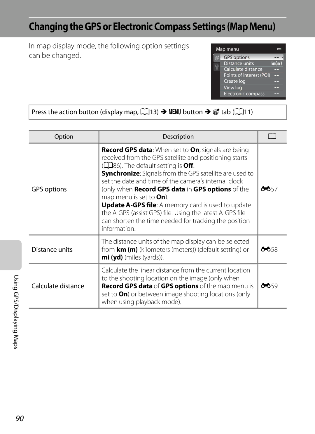
Displaying Maps
Displaying Maps
Map Display
GPS options
A86. The default setting is Off
When using playback mode
Map menu is set to On
Off
Page
General Camera Setup
General Camera Setup
Setup Menu
Sound settings Sound in the default setting E76
Blurring. The default setting is Auto E74 Motion detection
Or the scene mode that is selected
Operation sound is disabled
Setup Menu
Reference Section
Reference Section
Select Easy panorama and press the k button
Using Easy Panorama Shooting and Playing back
Taking Pictures with Easy Panorama
Or Wide 360, and press the k Button
Example of moving the camera
Using Easy Panorama Shooting and Playing back
When the guide showing the shooting point reaches
Iicons showing the panorama direction are displayed
Viewing Easy Panorama Scroll
Using Panorama Assist
Choose Panorama assist and press the k
Use the multi selector to choose the direction
Rexposure lock Indicator
Press the kbutton when shooting is completed
Using Panorama Assist
Shoot the next picture
Playing Images in a Sequence
Sequence Display Options
Changing Key Picture in Sequence
Playback Menu Options Available When Using Sequence
Deleting Images in a Sequence
Which the images will be added and press the kbutton
Favorite Pictures Mode
Adding Images to Albums
Use the multi selector to choose the album to
Removing Images From Albums
Favorite Pictures Mode
Playing Back Images in Albums
E10
Changing the Favorites Album Icon
Press H, I, Jor Kto choose an icon and press the kbutton
E11
Fireworks show scene mode A39
Auto Sort Mode
Auto Sort Mode Categories
E12
Auto Sort Mode
E13
List by Date Mode
E14
E15
Editing Features
Editing Images Still Pictures
Fisheye, Miniature effect and Fog removal
Restrictions on Image Editing
E16
Editing Images Still Pictures
Original Pictures and Edited Copies
KQuick Retouch Enhancing Contrast and Saturation
ID-Lighting Enhancing Brightness and Contrast
E17
To cancel, press J
Confirm the results
E18
E19
Adjust the effect and press the kbutton
PFilter Effects Applying Digital Filter Effects
Or Cyanotype
GSmall Picture Reducing the Size of an Image
E20
Image Size
ACrop Creating a Cropped Copy
E21
Cropping the Picture in its Current Tall Orientation
When connecting using a commercially available Hdmi cable
Connecting the Camera to a TV Playback on a TV
When connecting using the included audio/video cable
Turn off the camera Connect the camera to the TV
Using the TV’s Remote Control Hdmi Device Control
Connecting the Camera to a TV Playback on a TV
When Nothing Appears on the TV
E23
Printing Pictures
Connecting the Camera to a Printer Direct Print
E24
Take pictures
Turn off the camera Turn on the printer
Connecting the Camera to a Printer
Connecting the Camera to a Printer Direct Print
Turn on the camera
Printing Individual Images
E26
Printing starts
Printing Multiple Images
Choose the desired paper size and press the kbutton
E27
E28
Print selection
Print all images
E29
Paper Size
Current print/total number of prints
Press Hor Ito choose KChoose end
Editing Movies
Extracting Only the Desired Portions of the Movie
Point
E31
Editing Movies
Smart Portrait Menu
Image Mode Image Size and Quality
Smile Timer
Skin Softening
Blink Proof
E33
Smart Portrait Menu
E34
Shooting Menu AAuto Mode
White Balance Adjusting Hue
Manual for more information E35
Choose Measure
Using Preset Manual
Shooting Menu AAuto Mode
Press the kbutton to measure the white balance value
E36
Option Description Single default
Continuous Shooting
BSS Best Shot
ISO Sensitivity
E37
AF Area Mode
E38
E39
E40
Subject Tracking Mode Focusing on a Moving Subject
Press the shutter-release button to take the picture
Subject is registered
E41
Autofocus Mode
Autofocus Mode for Movie Recording
Choose how the camera focuses
Choose the pictures up to a maximum
Playback Menu
APrint Order Creating a Dpof Print Order
Number of copies up to nine per picture
E43
Playback Menu
E44
Favorite pictures mode Or auto sort mode
List by date mode
Deleting All Print Orders
Slide show begins
Press the cbutton Playback mode Mdbutton A11 MbSlide show
BSlide Show
Choose End or Restart
Press the c button Playback mode M dbutton A11 M dProtect
Protect
E46
Press Hor Ito select or deselect or the number of copies
Image Selection Screen
Press the multi selector Jor Kto choose the desired image
Press the kbutton to apply the image selection
FRotate Image
E48
Rotating Images in a Sequence
Playing Voice Memos
EVoice Memo
Recording Voice Memos
Deleting Voice Memos
Select a copy option and press the kbutton
HCopy Copy Between Internal Memory and Memory Card
Copy screen and press the kbutton
E50
E51
CSequence Display Options
XChoose Key Picture
Message Memory contains no images
Normal Speed Movies
Movie Menu
Movie Options
E52
E53
Open with HS Footage
HS Movies
Movie Menu
Press the bemovie-record button to start recording
Press the bemovie-record button to end recording
E54
15 s Playback Min Slow motion playback No sound
E55
HS Movie
Playback Min Fast motion playback No sound
Movie Light
Wind Noise Reduction
E56
Updating the A-GPS File
GPS Settings
Map Menu
E57
Map Menu
Distance Units
E58
Display a map A88 M dbutton M U tab A11 M Distance units
Calculate Distance
E59
E60
POI Display
E61
When log recording is completed, select End
Create Log Record the log of moving information
Log in Create log in the map menu, and press
To Erase Log Data
Select Save log, and press the kbutton
E62
Log data is saved to a memory card
E63
View Log View the log on a map
To Erase Log Data
Log Data
Electronic Compass
E64
E65
Welcome Screen
E66
Hour minute
Time Zone and Date
E67
Year/Month/Day, Month/Day/Year or Day/Month/Year
Press K
Setting the Travel Destination Time Zone
Choose xTravel destination and press the kbutton
Press Jor Kto choose the travel destination Time zone
E69
Time Zones
Monitor Settings
Photo info
E70
Auto info above, the movie frame is
E71
Addition to information shown with
Displayed before recording movies Reference Section
Print date and Print order
Print Date Imprinting Date and Time on Pictures
E72
Press the dbutton M ztab A11 M Print date
Vibration Reduction
On default Corrects for vibration caused by camera shake
Off Vibration reduction is not enabled
E73
Motion Detection
E74
Digital Zoom
Enable or disable the digital zoom
AF Assist
E75
Sound Settings
Adjust the following sound settings
E76
Auto Off
Auto Off Setting
Action Control Response
E77
Formatting the Internal Memory
Format Memory/Format Card
Language
Formatting Memory Cards
E79
TV Settings
Adjust the settings for connecting to a TV
Hdmi and HDMI-CEC
Blink Warning
Did someone blink? Screen
E80
Reset All
Assign Action Button
E81
E82
Setup Menu
E83
Others
Displays the current camera firmware version
Firmware Version
E84
Press the dbutton M ztab A11 M Firmware version
File and Folder Names
E85
E86
File and Folder Names
Optional Accessories
E87
Error Messages
Display Description Solution
E88
Error Messages
E89
E90
E91
E92
E93
E94
Caring for the Products
Troubleshooting
Specifications
Caring for the Camera
Caring for the Products
Camera
Handle the Lens and All Moving Parts with Care
Avoid Sudden Changes in Temperature
Do Not Drop
Keep away from Strong Magnetic Fields
Battery
Battery Charger
Memory Cards
Caring for the Camera
Cleaning
Cloth lightly dampened with commercial lens cleaner
Monitor
Storage
Caring for the Camera
User License Agreement for MAP Data and Location Name Data
Terms and Conditions
F10
User License Agreement for MAP Data and Location Name Data
F11
F12
See Error Messages E88 for more information
Troubleshooting
Power, Display and Settings Issues
Problem Cause/Solution
F14
Shooting Issues
Troubleshooting
Electronically Controlled Cameras
F15
When using skin softening function while shooting
F16
Corrected
Playback Issues
F17
F18
F19
Specifications
F20
Nikon Coolpix AW100 Digital Camera
Specifications
F21
F22
Specifications
Rechargeable Li-ion Battery EN-EL12
Battery Charger MH-65
Supported Standards
Index
Symbols
Playback zoom 33 C Scene mode
F24
F25
Extracting parts of the movie 84 Eyelet for camera strap
File name E85 Fill flash 55 Filter adapter
Shooting 26 Shooting menu
F26
Subject tracking 52, E39, E40 Sunset h Tele
Thumbnail Playback 33 Time difference E69 Time zone 24, E69
F27
FX1H0311
Nikon Corporation