- 8 -
Most observers will want to have 3 or 4 eyepieces and perhaps the #140 2x Barlow Lens to achieve the full range of reasonable magnifications. See OPTIONAL ACCESSORIES, page 11, for further details.
ASTRONOMICAL OBSERVING
The Starfinder telescope is an excellent observing tool for the serious amateur astronomer. The range of observable astronomical objects is, with minor qualification, limited only by the observer's motivation.
This section provides a basic introduction to the terminology associated with astronomy, and includes instructions for finding, following and photographing celestial objects.
Celestial Coordinates:
Declination and Right Ascension
Celestial objects are mapped according to a coordinate system on the Celestial Sphere, the imaginary sphere on which all stars appear to be placed. This celestial object mapping system is analogous to the
The poles of the celestial coordinate system are defined as those two points where the Earth's rotational axis, if extended to infinity, north and south, intersect the celestial sphere (Fig. 10). Thus, the North Celestial Pole is that point in the sky where an extension of the Earth's axis through the North Pole intersects the celestial sphere. This point in the sky is located near the North Star, Polaris.
In mapping the surface of the Earth, lines of longitude are drawn between the North and South Poles. Similarly, lines of latitude are drawn in an
Fig. 10: The Celestial Sphere.
Just as on the surface of the Earth, in mapping the celestial sphere imaginary lines have been drawn to form a coordinate grid. Thus, celestial object positions on the Earth's surface are specified by their latitude and longitude. For example, Los Angeles, California, can be located by its latitude (34°) and longitude (118°); similarly, the constellation Ursa Major can be located by its position on the celestial sphere:
R.A.: 11hr; Dec: +50° .
The celestial analog to Earth latitude is called Declination, or "Dec", and is measured in degrees, minutes and seconds (e.g., 15° 27' 33"). Declination shown as north of the celestial equator is indicated with a "+" sign in front of the measurement (e.g., the Declination of the North Celestial Pole is +90°), with Declination shown as south of the celestial equator indicated with a
(e.g., the Declination of the South Celestial Pole is
The celestial analog to Earth longitude is called "Right Ascension", or "R.A.", and is measured in time on the 24 hour "clock" and shown in hours ("hr"), minutes ("min") and seconds ("sec") from an arbitrarily defined "zero" line of Right Ascension passing through the constellation Pegasus. Right Ascension coordinates range from 0hr 0min 0sec to 23hr 59min 59sec. Thus there are 24 primary lines of R.A., located at 15 degree intervals along the celestial equator. Objects located further and further east of the prime Right Ascension grid line (0hr 0min 0sec) carry increasing R.A. coordinates.
All celestial objects are specified in position by their celestial coordinates of Right Ascension and Declination. The telescope's Dec and R.A. setting circles (8) and (17), Fig. 1, may be dialed to the coordinates of a specific celestial object, which may then be located without a visual search. However, before making use of the telescope's setting circles to locate celestial objects, your telescope must first be polar aligned.
Polar Alignment
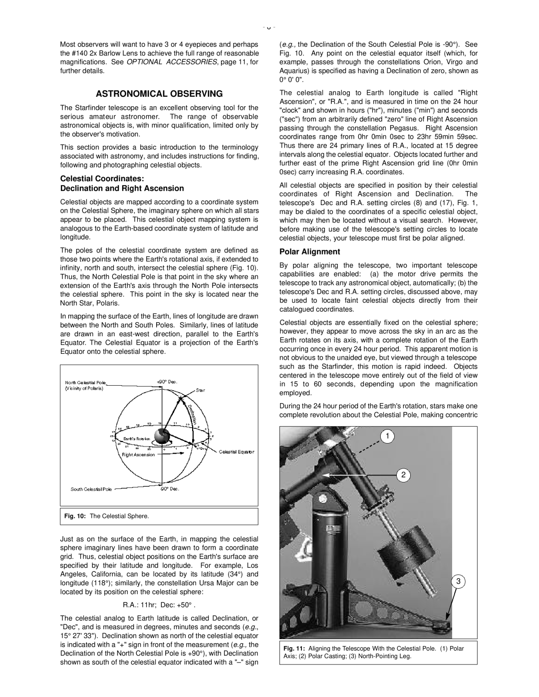
By polar aligning the telescope, two important telescope capabilities are enabled: (a) the motor drive permits the telescope to track any astronomical object, automatically; (b) the telescope's Dec and R.A. setting circles, discussed above, may be used to locate faint celestial objects directly from their catalogued coordinates.
Celestial objects are essentially fixed on the celestial sphere; however, they appear to move across the sky in an arc as the Earth rotates on its axis, with a complete rotation of the Earth occurring once in every 24 hour period. This apparent motion is not obvious to the unaided eye, but viewed through a telescope such as the Starfinder, this motion is rapid indeed. Objects centered in the telescope move entirely out of the field of view in 15 to 60 seconds, depending upon the magnification employed.
During the 24 hour period of the Earth's rotation, stars make one complete revolution about the Celestial Pole, making concentric
1
2
3