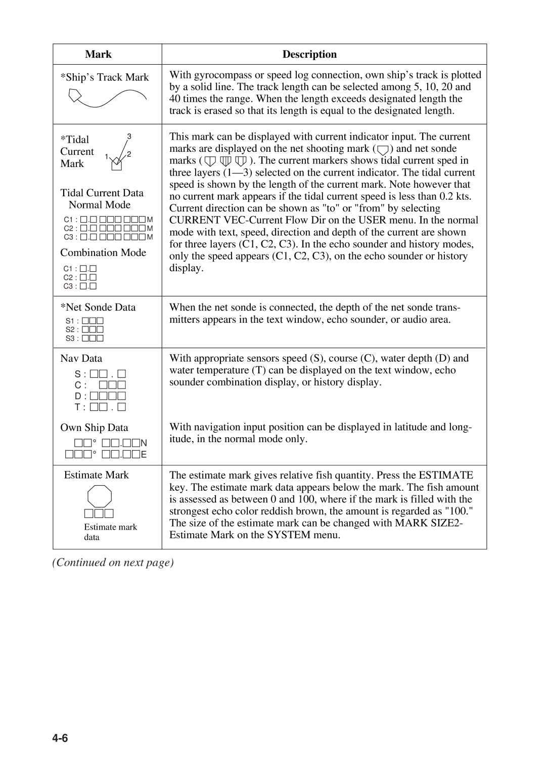
Mark |
|
|
| Description | |||
|
|
| |||||
*Ship’s Track Mark | With gyrocompass or speed log connection, own ship’s track is plotted | ||||||
|
|
|
| by a solid line. The track length can be selected among 5, 10, 20 and | |||
|
|
|
| 40 times the range. When the length exceeds designated length the | |||
|
|
|
| track is erased so that its length is equal to the designated length. | |||
|
|
|
|
|
| ||
*Tidal |
| 3 |
| This mark can be displayed with current indicator input. The current | |||
|
|
| marks are displayed on the net shooting mark ( ) and net sonde | ||||
Current | 1 | 2 |
| ||||
| marks ( | ). The current markers shows tidal current sped in | |||||
Mark |
|
| |||||
|
|
| |||||
|
|
| three layers | ||||
|
|
|
| ||||
Tidal Current Data | speed is shown by the length of the current mark. Note however that | ||||||
no current mark appears if the tidal current speed is less than 0.2 kts. | |||||||
Normal Mode |
| ||||||
| Current direction can be shown as "to" or "from" by selecting | ||||||
|
|
|
| ||||
C1 : . |
|
| M | CURRENT | |||
C2 : . |
|
| M | mode with text, speed, direction and depth of the current are shown | |||
C3 : . |
|
| M | ||||
|
| for three layers (C1, C2, C3). In the echo sounder and history modes, | |||||
Combination Mode | |||||||
only the speed appears (C1, C2, C3), on the echo sounder or history | |||||||
|
|
|
| ||||
C1 : . |
|
|
| display. |
|
| |
C2 : . |
|
|
|
|
|
| |
C3 : . |
|
|
|
|
|
| |
|
|
|
|
| |||
*Net Sonde Data |
| When the net sonde is connected, the depth of the net sonde trans- | |||||
S1 : |
|
|
| mitters appears in the text window, echo sounder, or audio area. | |||
S2 : |
|
|
|
|
|
| |
S3 : |
|
|
|
|
|
| |
|
|
|
|
|
| ||
Nav Data |
|
|
| With appropriate sensors speed (S), course (C), water depth (D) and | |||
S : | . |
|
| water temperature (T) can be displayed on the text window, echo | |||
|
| sounder combination display, or history display. | |||||
C : |
|
|
| ||||
D : |
|
|
|
|
|
| |
T : | . |
|
|
|
|
| |
Own Ship Data |
| With navigation input position can be displayed in latitude and long- | |||||
° |
| . | N | itude, in the normal mode only. | |||
| |||||||
° |
| . | E |
|
|
| |
|
|
|
| ||||
|
|
|
|
|
|
| |
Estimate Mark |
| The estimate mark gives relative fish quantity. Press the ESTIMATE | |||||
|
|
|
| key. The estimate mark data appears below the mark. The fish amount | |||
|
|
|
| is assessed as between 0 and 100, where if the mark is filled with the | |||
|
|
|
| strongest echo color reddish brown, the amount is regarded as "100." | |||
Estimate mark |
| The size of the estimate mark can be changed with MARK SIZE2- | |||||
| Estimate Mark on the SYSTEM menu. | ||||||
data |
|
|
| ||||
|
|
|
|
|
|
| |
(Continued on next page)