configuration the observer does not need to press the Arrow keys of the Electronic Controller in order to track celestial objects. However, the Arrow keys of the Electronic Controller are useful in this configuration to enable the centering of objects within the telescopic field or, for example, to move the telescope over the surface of the Moon or through a large star field.
Celestial Coordinates
Before polar aligning your ETX model, it is helpful to understand how to locate celestial objects as they move across the sky.
A celestial coordinate system was created that maps an imaginary sphere surrounding the Earth upon which all stars appear to be placed. This mapping system is similar to the system of latitude and longitude on Earth surface maps.
In mapping the surface of the Earth, lines of longitude are drawn between the North and South Poles and lines of latitude are drawn in an
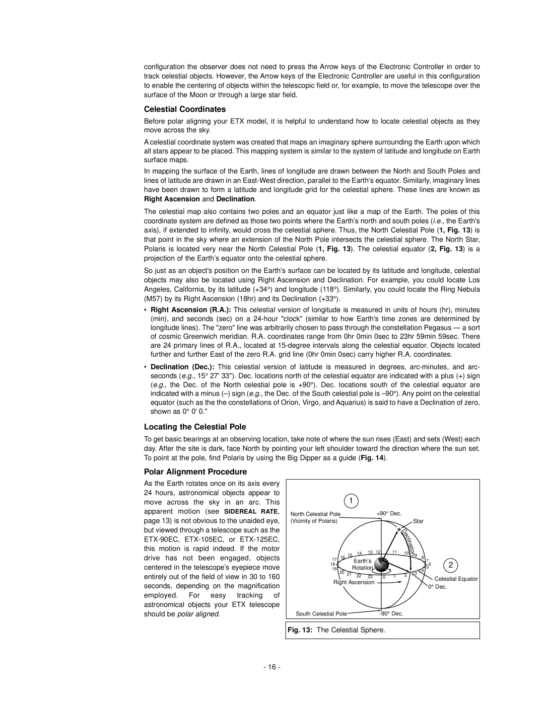
The celestial map also contains two poles and an equator just like a map of the Earth. The poles of this coordinate system are defined as those two points where the Earth’s north and south poles (i.e., the Earth's axis), if extended to infinity, would cross the celestial sphere. Thus, the North Celestial Pole (1, Fig. 13) is that point in the sky where an extension of the North Pole intersects the celestial sphere. The North Star, Polaris is located very near the North Celestial Pole (1, Fig. 13). The celestial equator (2, Fig. 13) is a projection of the Earth’s equator onto the celestial sphere.
So just as an object's position on the Earth’s surface can be located by its latitude and longitude, celestial objects may also be located using Right Ascension and Declination. For example, you could locate Los Angeles, California, by its latitude (+34°) and longitude (118°). Similarly, you could locate the Ring Nebula (M57) by its Right Ascension (18hr) and its Declination (+33°).
•Right Ascension (R.A.): This celestial version of longitude is measured in units of hours (hr), minutes (min), and seconds (sec) on a
•Declination (Dec.): This celestial version of latitude is measured in degrees,
Locating the Celestial Pole
To get basic bearings at an observing location, take note of where the sun rises (East) and sets (West) each day. After the site is dark, face North by pointing your left shoulder toward the direction where the sun set. To point at the pole, find Polaris by using the Big Dipper as a guide (Fig. 14).
Polar Alignment Procedure
As the Earth rotates once on its axis every 24 hours, astronomical objects appear to move across the sky in an arc. This apparent motion (see SIDEREAL RATE, page 13) is not obvious to the unaided eye, but viewed through a telescope such as the
| 1 |
|
|
|
|
|
|
|
|
|
North Celestial Pole |
|
|
| +90° Dec. |
|
| ||||
(Vicinity of Polaris) |
|
|
|
|
|
|
| D | Star |
|
|
|
|
|
|
|
|
|
|
| |
|
|
|
|
|
|
|
| e |
|
|
|
|
|
|
|
|
|
| c |
| |
|
|
|
|
|
|
|
| l |
| |
|
|
|
|
|
|
|
| i |
| |
|
|
|
|
|
|
|
| n |
| |
|
|
|
|
|
|
|
| a |
| |
|
|
|
|
|
|
|
|
| t |
|
|
|
|
|
|
|
|
|
| i |
|
|
| 14 | 13 | 12 |
|
| 11 | 10 | o |
|
17 16 15 |
|
| n |
| ||||||
Earth’s |
|
|
|
|
| 9 8 7 | 2 | |||
18 | Rotation |
|
|
|
|
| 56 | |||
19 |
|
|
|
|
| 4 |
| |||
20 | 21 |
|
|
|
|
|
|
|
| |
22 | 23 |
|
| 0 | 1 | 2 | 3 | Celestial Equator | ||
|
|
|
|
| ||||||
Right Ascension |
|
|
|
|
|
| ||||
|
|
|
|
| 0° Dec. | |||||
|
|
|
|
|
|
|
|
| ||
South Celestial Pole |
|
|
| - |
| 90° Dec. |
|
| ||
|
|
|
|
|
| |||||
|
|
|
|
|
|
|
|
|
|
|
Fig. 13: The Celestial Sphere.
- 16 -