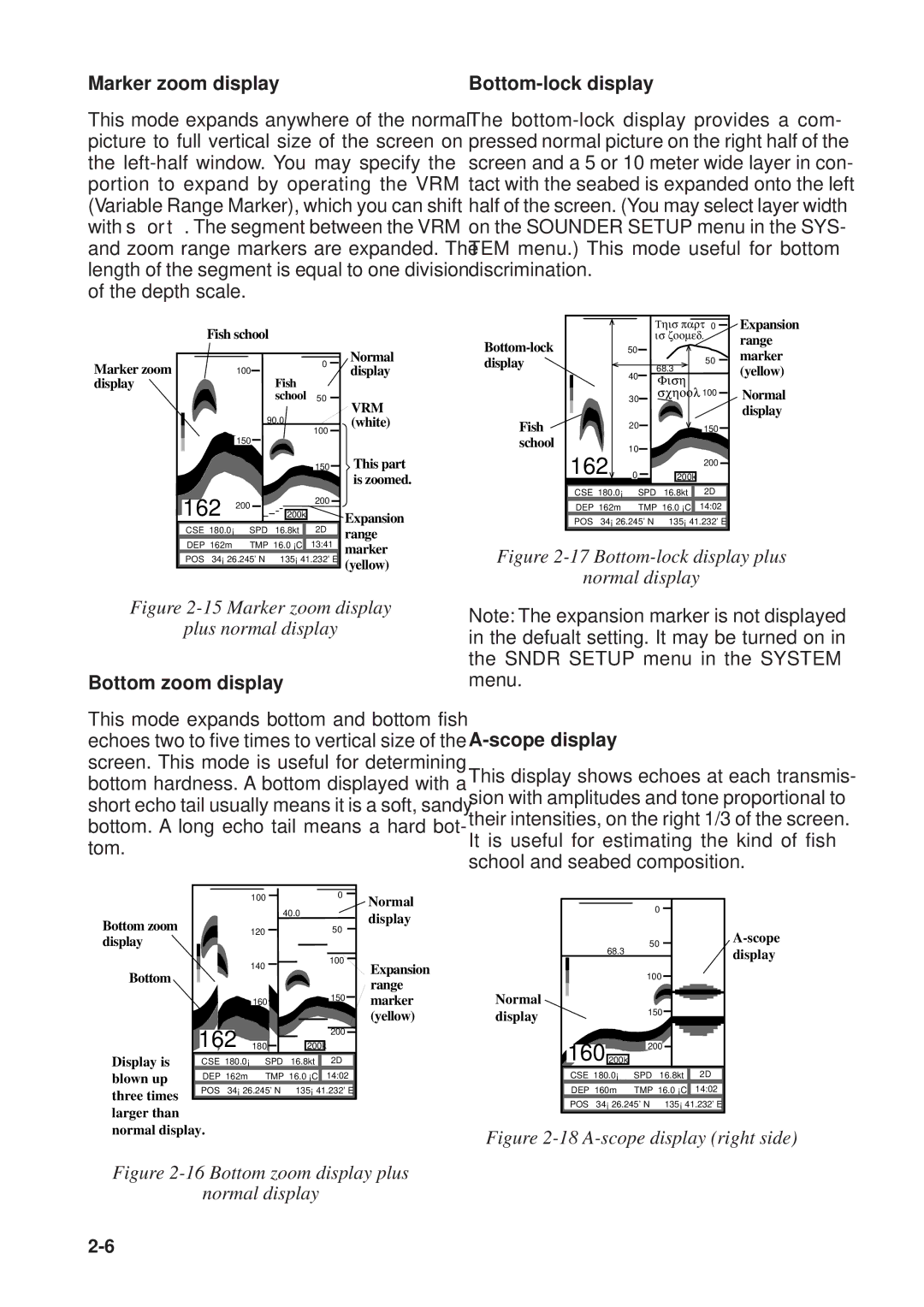
Marker zoom display

This mode expands anywhere of the normal picture to full vertical size of the screen on the left-half window. You may specify the portion to expand by operating the VRM (Variable Range Marker), which you can shift with or . The segment between the VRM and zoom range markers are expanded. The length of the segment is equal to one division of the depth scale.

Bottom-lock display

The bottom-lock display provides a com- pressed normal picture on the right half of the screen and a 5 or 10 meter wide layer in con- tact with the seabed is expanded onto the left half of the screen. (You may select layer width on the SOUNDER SETUP menu in the SYS- TEM menu.) This mode useful for bottom discrimination.

Fish school

This part

0

is zoomed.


Expansion range

Marker zoom display

0

100


Fish


school

50


90.0


100


150


150


200


162


200


200k


CSE 180.0°

SPD 16.8kt


2D


Normal display

VRM (white)

This part is zoomed.

Expansion range

Bottom-lock display

Fish school


50


68.3


50


40


Fish


30


school

100


20


150


162

10


200


0


200k


CSE 180.0°


SPD

16.8kt


2D


DEP 162m


TMP 16.0 °C

14:02


POS 34° 26.245' N

135° 41.232' E


marker (yellow)

Normal display

DEP 162m TMP 16.0 °C


13:41


POS 34° 26.245' N 135° 41.232' E

marker (yellow)

Figure 2-17 Bottom-lock display plus

normal display

Figure 2-15 Marker zoom display

plus normal display

Bottom zoom display

This mode expands bottom and bottom fish echoes two to five times to vertical size of the screen. This mode is useful for determining bottom hardness. A bottom displayed with a short echo tail usually means it is a soft, sandy bottom. A long echo tail means a hard bot- tom.


100


0


Normal


40.0


Bottom zoom


display


50


120


display


Bottom


140


100


Expansion


range


150


marker


160


(yellow)


162


200


Display is

180


200k


CSE 180.0°

SPD

16.8kt


2D


blown up


DEP 162m

TMP 16.0 °C


14:02


three times


POS 34° 26.245' N

135° 41.232' E


larger than


normal display.


Figure 2-16 Bottom zoom display plus

normal display

Note: The expansion marker is not displayed in the defualt setting. It may be turned on in the SNDR SETUP menu in the SYSTEM menu.

A-scope display

This display shows echoes at each transmis- sion with amplitudes and tone proportional to their intensities, on the right 1/3 of the screen. It is useful for estimating the kind of fish school and seabed composition.


0


50

A-scope

68.3


display


100


Normal


display


150


160 200k


200


CSE 180.0°

SPD

16.8kt

2D

DEP 160m

TMP 16.0 °C

14:02

POS 34° 26.245' N

135° 41.232' E

Figure 2-18 A-scope display (right side)

2-6

Page 42
Image 42
Furuno GP-1610CF manual Marker zoom display, Bottom-lock display, Bottom zoom display, Scope display

GP-1610CF specifications

The Furuno GP-1610CF is a sophisticated marine navigation system designed for enthusiasts who demand accuracy and reliability on the water. Featuring a 10.4-inch color LCD display with a resolution of 640 x 480 pixels, this unit provides crystal-clear images of charts and navigation information, even under direct sunlight. Its user-friendly interface allows for intuitive management of various functions, making it accessible for both novice and experienced mariners.

One of the standout features of the GP-1610CF is its integrated GPS receiver, which boasts a high sensitivity that ensures rapid acquisition of satellite signals and precise positioning. The unit supports a range of positioning formats, including WAAS (Wide Area Augmentation System), allowing for enhanced accuracy within the coastal dimensions. Additionally, the GP-1610CF is compatible with DGPS (Differential GPS) systems, further refining positional accuracy and providing a reliable navigation experience.

The GP-1610CF also supports C-MAP NT+ charting, offering an extensive variety of cartographic data covering numerous regions. This enables users to visualize marine environments with detailed bathymetric information, harbor layouts, and navigational aids. The system's customizable waypoints and route planner facilitate efficient marine navigation, allowing users to create multiple routes and track them in real time.

In terms of connectivity, the GP-1610CF offers NMEA 0183 output, which allows it to interface seamlessly with other marine electronics such as autopilots, radar systems, and depth sounders. This enabling communication between devices enhances overall situational awareness and improves navigation assistance.

The unit is built to withstand the harsh marine environment, featuring a robust housing that is resistant to saltwater, humidity, and temperature variations. Additionally, the GP-1610CF can function in challenging lighting conditions thanks to its adjustable contrast and brightness settings, which help maintain visibility during nighttime operation.

Overall, the Furuno GP-1610CF stands as a reliable choice for sailors seeking a high-performance navigation solution. With its combination of advanced GPS technology, high-resolution display, extensive chart compatibility, and robust design, this device continues to be a trusted companion for marine adventures around the globe. Whether cruising, fishing, or engaging in professional navigation, the GP-1610CF delivers essential features that empower users to navigate with confidence and accuracy.