HDS-5 & HDS-7
Software updates for your unit
Table of contents
Contents
113
Blank
Introduction
About this manual Manual Conventions
Lowrance HDS-5 and HDS-7
Getting Started
Selecting Chart Data
To select Chart data
Menus
Closing Menus
Selecting a Fishing Mode
To select a fishing mode
Entering Letters in Text Boxes
To enter data in a text box
Restore Defaults
To Restore Defaults
Selecting Pages
Pages
Pages Screen
To access Edit Data Overlay menu
Data Overlay
Data Overlay menu
Edit Overlay menu
Edit Mode
Move or Placing a Gauge
To move or place a gauge
Select Data
Size
To select data overlay
Type
To save changes
To configure limits
Limits
Configuration menu
Add Source
To use Add Source
To remove add source data
Chart
On the Chart Page you can
Sonar
On the Sonar Page you can
Radar
Info
On the Radar Page you can
On the Info Page you can
Data menu
Dash 1, Dash 2 and Dash
Gauge Layout Templates
Edit
Edit Data menu
To edit gauge display
Enter. a list of subcategories will appear
To remove a source
To select data
To add source
To Finish Editing
Change Layout
To change layout
Add Dashboard
Settings
To access Utilities
Utilities
Utilities
To copy data files/sonar logs
To delete data files/sonar logs
To display a combo
Displaying Combo Pages
Selecting an Active
To display multiple panels
Adjust Panel Sizes
Displaying Multiple Panels
To adjust panel sizes
Blank
To access the Sonar
Sonar Operation
Sensitivity
Sonar Menu
Auto Sensitivity
Colorline
Range
Frequency
Split
Stop Sonar
Adjust
To Adjust Sensitivity and Colorline
To set Upper and Lower Limits
Sonar Options
Custom Upper and Lower Limits
Ping Speed
To select a Palette
Palette
To select a Split option
Temperature Graph
Depth Line
Amplitude Scope
Zoom Bars
To select Fish ID option
Log Sonar Data
Fish ID
Start Logging
To input filename
To select Save to or Bytes per Sounding
To stop logging
Chart Operation
Displaying the Chart
Chart page 2D Chart mode
Access the Chart page from the Pages menu
Find Current Position
Chart menu
On the Chart
Selecting POIs on Chart page with Cursor
To select a Chart page POI
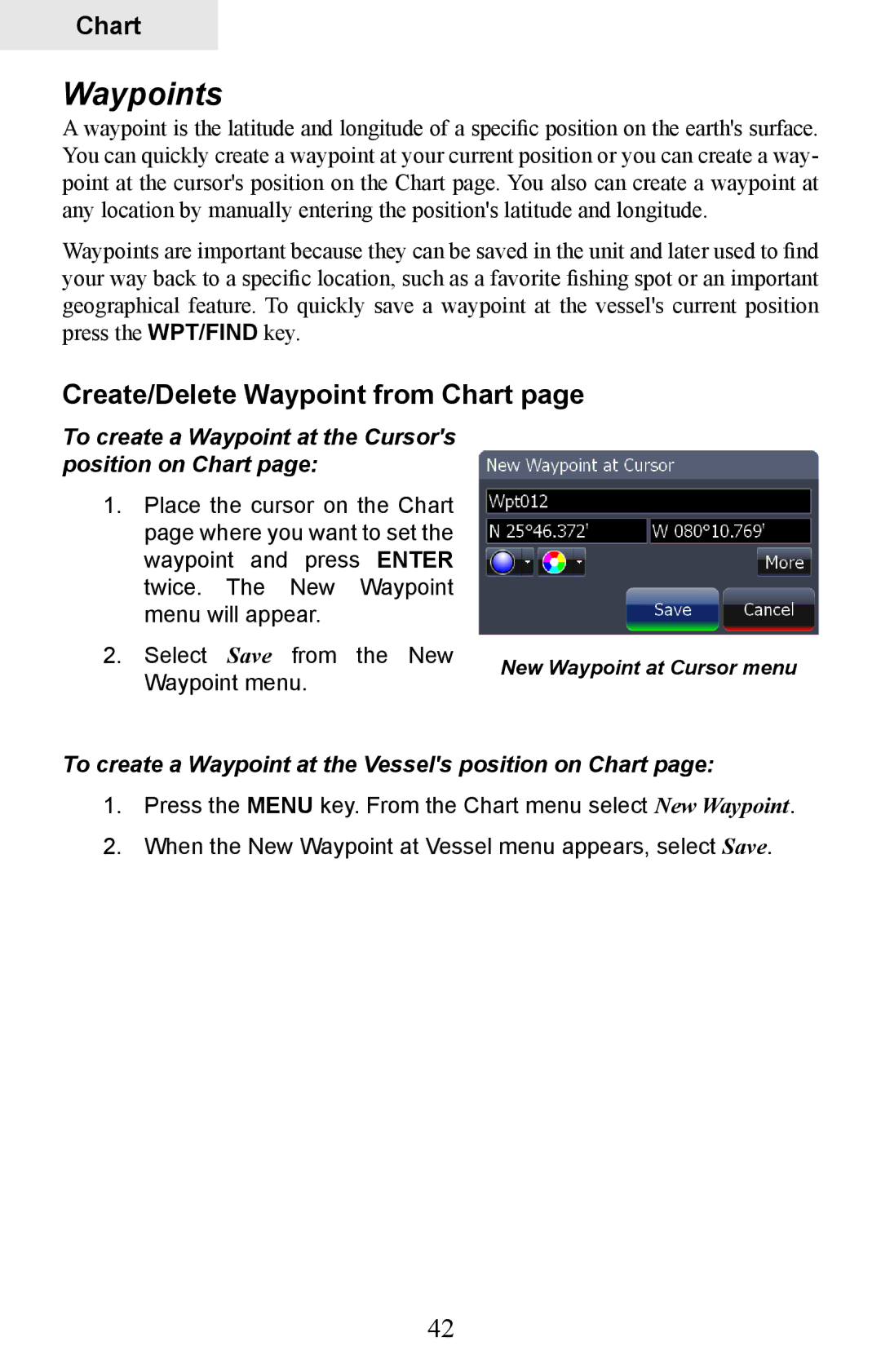
Create/Delete Waypoint from Chart
To create a Waypoint at the Cursors position on Chart
To create a Waypoint at the Vessels position on Chart
Waypoints
Waypoints screen
To Navigate to a Waypoint from the Waypoints screen
To Search for Waypoint by Name
Waypoints screen menu
Waypoints screen, Search for Waypoint by name
Waypoints screen, Sort Waypoints feature
Editing a Waypoint on the Chart
Waypoint Information screen
Edit Waypoint menu
To Edit Waypoint depth or alarm radius
Edit Waypoint name, description, position or depth
To Edit Waypoint name or description
To Edit Waypoint position
Create Route from Chart
To Create a New Route from the Chart
Routes
Edit Waypoint icon and color
Chart
Routes screen
Routes screen menu
To Edit Route
To Display / Hide Route
To Insert, Edit or Remove Waypoints from a Route
To Navigate Route from Routes screen
To Search for Route by Name
Trails
Trails screen
Trails screen menu
New Trail menu
To edit a Trail name
Edit Trail menu
Trail line Color options
Search by Coordinates
Measuring Distances on Chart
Find Chart item
To change Chart page orientation
To select / deselect the Look Ahead feature
Map Orientation
Look Ahead
Chart categories
To select / deselect Chart Categories
2D and Shaded Relief
Shaded Relief only available on U.S. models
To turn on radar overlay
Chart page Icons, Tides and Currents
Radar Overlay
To view Navionics data
Navionics
Radar Options
To change Navionics Settings
Navionics Settings menu
Navionics Settings and Options
Platinum or Platinum Plus charts
Radar menu
To access the Radar
Radar Operation
Adjust menu
Radar State
Clear Trails
Position
To change the PPI position
Symbology
EBL/VRM
Adjust
To adjust an EBL/VRM
EBL/VRM menu
To select an EBL/VRM
Cursor position window
Radar Overlay
Blank
Settings Menu
To access the System menu
System
Language
Key Beeps
Time
Magnetic Variation
Datum
Coord System
Satellites
To save screen captures to MMC/SD card
Screen Capture
To take a screen capture
Advanced
Restore Defaults
To access Advanced Settings
About
To adjust Waypoint, Hardware, Flywheel and Radar settings
To adjust cursor settings
Chart Settings Menu
Chart Data
To access the Chart Settings Menu
Range Rings
Popup Information
Grid Lines
Waypoints
To use Heading Extension
Trails
Hide Chart
Routes
Sonar Settings Menu
Sonar Source
Network Sonar
Noise Rejection
Manual Mode
To adjust Surface Clarity
Surface Clarity
Scroll Speed
Fishing Modes
Keel Offset
Installation Menu
Reset Fishing Mode
To calibrate Water Speed
Water Speed Calibration
To set Keel Offset
Temperature Calibration
Temperature Averaging
Water Speed Averaging
To select a Water Averaging interval
Reset Water Distance
To select a Temperature Averaging interval
Transducer Type
To select a Transducer Type
Radar Settings Menu
Target Expansion
Target Trails
Palette
North Indicator
Orientation
Threshold
To change Map Orientation
Bearings
Range Markers
Compass
Installation
To access Radar Installation menu
Installation Adjustment Menu
To set T/M or R
To select Heading up orientation
To Adjust Bearing Alignment
Bearing alignment
To Adjust Range Offset
To Adjust Antenna Height
Range offset
Antenna Height
Reset Radar to Factory Defaults
To Adjust Open Array Park Angle
Open Array Park Angle
Tune
To input fuel added
Fuel
Refuel
To set tank to full
To calibrate engines
Vessel Setup
Fuel Used
Engine/Tank Configuration
To select engine-tank configuration
To input tank size
Calibrate
Alarms
To enable/disable an Alarm
Siren Enabled
To silence an alarm
To set alarm limit
Set Limit
Logging Type
To select a Logging Type
Distance Period
To set Distance period
Units
100
Time Period
To set Time Period
Network
101
102
103
104
Configuring Devices
To configure a device name or device tank size
To configure device location
To access calibration instructions
105
Instance
Nmea 2000 receive/send waypoint
Diagnostics
106
To configure serial ports
To access Nmea 0183 Output screen
107
Serial Ports
108
Mmsi Maritime Mobile Service Identity
Vessels
To use Course Extension
109
Course Extension
Simulator
110
111
112
Specifications
113
Connectors
Unit Care
Display
Buttons
Troubleshooting
Unit won’t turn on
Unit freezes, locks up, or operates erratically
Weak bottom echo, erratic readings or no fish returns
116
No fish arches when Fish I.D. is turned off
117
Noise
118
GPS Not Accurate
119
120
Cards not Read by Unit
Current Position not on the Screen
Update the Software
Reset the Unit
Radar won’t Start Up
121
122
123
Symbols
Index
124
Nmea
125
126