North |
|
|
|
|
|
|
|
|
|
|
|
Celestial |
|
|
| +90 | Dec. |
|
|
|
| ||
Pole |
|
|
|
|
|
|
|
| Star |
| |
|
|
|
|
|
|
|
|
| |||
(Vicinity |
|
|
|
|
|
|
|
|
| ||
|
|
|
|
|
|
|
|
|
|
| |
of Polaris) |
|
|
|
|
|
| e |
|
|
| |
|
|
|
|
|
|
| D |
|
|
| |
|
|
|
|
|
|
|
| c |
|
| |
1 |
|
|
|
|
|
|
| l |
|
| |
|
|
|
|
|
|
| a |
|
| ||
|
|
|
|
|
|
|
| i |
|
| |
|
|
|
|
|
|
|
| n |
|
| |
|
|
|
|
|
|
|
|
| t |
|
|
|
|
|
|
|
|
|
|
| i |
|
|
|
| 14 | 13 | 12 |
|
| 11 | 10 | o |
|
|
| 15 |
|
| n |
|
| |||||
17 16 |
|
|
|
|
|
|
| 9 | 8 |
| |
Earth’s |
|
|
|
|
|
| 7 | ||||
18 | Rotation |
|
|
|
|
|
|
| 6 | ||
19 |
|
|
|
|
|
| 4 | 5 | |||
20 | 21 |
|
|
|
|
|
| 2 | 3 | Celestial | |
22 | 23 |
|
| 0 | 1 |
| |||||
|
|
|
|
|
| Equator | |||||
Right Ascension |
|
|
|
|
|
|
| ||||
|
|
|
|
|
|
| 0 Dec. | ||||
|
|
|
|
|
|
|
|
|
|
| |
South |
|
|
|
|
|
|
|
|
|
| 2 |
|
|
|
|
|
|
|
|
|
|
| |
Celestial |
|
| - |
| 90 | Dec. |
|
|
|
| |
Pole |
|
|
|
|
|
|
|
| |||
|
|
|
|
|
|
|
|
|
|
| |
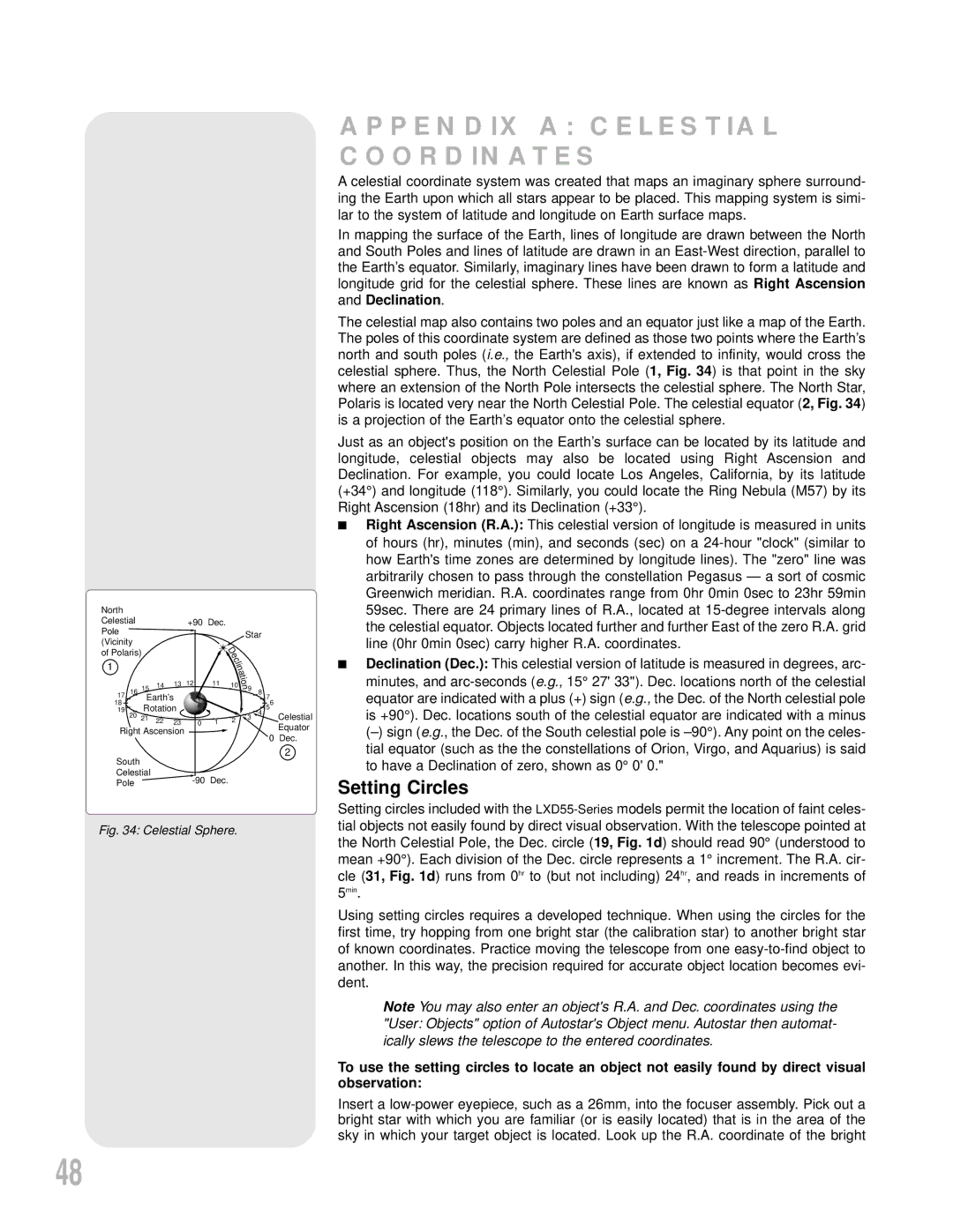
Fig. 34: Celestial Sphere.
APPENDIX A: CELESTIAL COORDINATES
A celestial coordinate system was created that maps an imaginary sphere surround- ing the Earth upon which all stars appear to be placed. This mapping system is simi- lar to the system of latitude and longitude on Earth surface maps.
In mapping the surface of the Earth, lines of longitude are drawn between the North and South Poles and lines of latitude are drawn in an
The celestial map also contains two poles and an equator just like a map of the Earth. The poles of this coordinate system are defined as those two points where the Earth’s north and south poles (i.e., the Earth's axis), if extended to infinity, would cross the celestial sphere. Thus, the North Celestial Pole (1, Fig. 34) is that point in the sky where an extension of the North Pole intersects the celestial sphere. The North Star, Polaris is located very near the North Celestial Pole. The celestial equator (2, Fig. 34) is a projection of the Earth’s equator onto the celestial sphere.
Just as an object's position on the Earth’s surface can be located by its latitude and longitude, celestial objects may also be located using Right Ascension and Declination. For example, you could locate Los Angeles, California, by its latitude (+34°) and longitude (118°). Similarly, you could locate the Ring Nebula (M57) by its Right Ascension (18hr) and its Declination (+33°).
■Right Ascension (R.A.): This celestial version of longitude is measured in units of hours (hr), minutes (min), and seconds (sec) on a
■Declination (Dec.): This celestial version of latitude is measured in degrees, arc- minutes, and
Setting Circles
Setting circles included with the
5min.
Using setting circles requires a developed technique. When using the circles for the first time, try hopping from one bright star (the calibration star) to another bright star of known coordinates. Practice moving the telescope from one
Note You may also enter an object's R.A. and Dec. coordinates using the "User: Objects" option of Autostar's Object menu. Autostar then automat- ically slews the telescope to the entered coordinates.
To use the setting circles to locate an object not easily found by direct visual observation:
Insert a
48