Dell Streak
May Federal Communications Commission FCC Statement
Contents
Managing Your Device Settings
Using Your Dell Streak
Protect Your Device Data With a
Protect Your SIM Card With
101
Connect to a Computer and Install
126
127
Package Contents
Buttons/Connectors/Parts Functionality
Dell Streak Features
Buttons/Connectors/Parts Functionality
Display→ Automatic Backlight
Parts/controls Functionality
Getting Your Device Ready for Use
Setting Up Your Dell Streak
Remove the back cover
Insert the SIM card
Install the microSD card
Insert the battery
Charge the device
Close the back cover
Turning On Your Device
Turning Off Your Device
Turning Off the Screen
Understanding Your Dell Streak
Touch Screen
Finger Gestures Allows you to Touch
Drag
Finger Gestures Allows you to Touch and hold
Zoom-out
Finger Gestures Allows you to Flick or swipe
Screen Orientation
Applications, Widgets, and Shortcuts
Finger Gestures Allows you to Zoom-in
Multiple Home Screens
Home Screen
To navigate across the Home screens
To add a Home screen
To add an item to a Home screen
Customizing Your Home Screen
Applications
Items Steps Shortcuts
Widgets
Directions
Wallpapers
Items Steps Folders
To remove a Home screen item
To move a Home screen item
To open a Home screen folder
To close a Home screen folder
To rename a folder
To remove a Home screen shortcut from a folder
Or Less
Status Bar
Status area may also display some of the following icons
Download in progress
Navigating the Applications
Favorites Bar
To add applications to the Favorites bar
Application Shortcuts
To open an application using the application shortcuts
Recent applications
To remove applications from the Favorites bar
Calling
Using Your Dell Streak
Making Calls
To make a call
To cancel dialing
To manage and redial missed, dialed, and received calls
To answer a call
Manage Your Calls
To use the speakerphone during a call
To accept calls using a Bluetooth headset
To accept a waiting call
To dial another call during an active call
To conduct a conference call
Adjust Call Settings
Fixed Dialing Numbers
Voicemail
HAC mode
Additional call settings
Teletypewriter TTY
Mode
Managing Contacts
Contacts
To add a new contact
To view the contact details
While entering the contact details, you can
To add contacts from your SIM card
To compose and send a text message
Messaging
Picture
To compose and send a multimedia message
Capture picture
Video
Record audio
Audio
Slideshow
Receiving text and multimedia messages
To read a text message
If the message contains
To view a multimedia message
To forward the message
To reply to a text or multimedia message
To delete a message or a message thread
On-Screen Keyboard
Pop-Up Menu
Keyboard controls
To configure the keyboard settings
Create your personal dictionary
→ Locale Text→ Android keyboard
To edit a word in the dictionary
To add a word to the dictionary
To delete a word from the dictionary
→ User dictionary
Google Search
Widgets
To search by typing
To search by voice
To find your RSS feeds URL
To subscribe to RSS feeds
To read RSS feeds
Twitter
Facebook
To check storage spaces
Managing Your Device Settings
To erase unwanted application data to free storage space
To format the microSD card
To reset your device to the default state
Touch Reset device
To upgrade the software version on your device
To erase all data from your device
Using Your Dell Streak
Connecting to the Web
To connect to the web using GPRS, EDGE, 3G, or Hspa
Web
To automatically select a new network
To manually select a new network
To turn on Wi-Fi and connect to a network
Wi-Fi
To connect to another Wi-Fi network
To check the current Wi-Fi network connection
Browsing the Web
Disable all Connections Using the Airplane Mode
To open the browser
To use the browser controls bar
Viewing Web Pages
To switch between browser windows
To find text within a web
To copy text on a web
Using Web Links, History, and Downloads
To select a link on a web
To check the history of visited web pages
Manage Bookmarks
To install an application
To allow download of web applications
To check downloads
To configure browser settings
To open a bookmark
To manage your bookmarks
Mail
To set up an e-mail account
To open the e-mail application
To compose and send e-mails
To delete an e-mail
TouchDown
To delete or edit an e-mail account on your device
To open the TouchDown application
Side toolbar
To quickly set up your exchange server account
Web Applications
To set up your Google account
Gmail
Status area
Web
To refresh Gmail
To view e-mails in different folders or with labels
To read e-mails
To create and send an e-mail
Google Talk
To activate Google Talk
To sign in automatically
To view and accept an invitation
To add a new friend to your friends list
To change your online status and message
To start a conversation
To switch between active conversations
To disable the chat log
To add a friend to an active conversation
To close a conversation
Touch Pin friend
To pin a friend
To block a friend from sending you messages
To permanently remove a friend
Maps
Web
To move around a map
To zoom in or out on a map
To change map layers
Traffic layer
Map layer
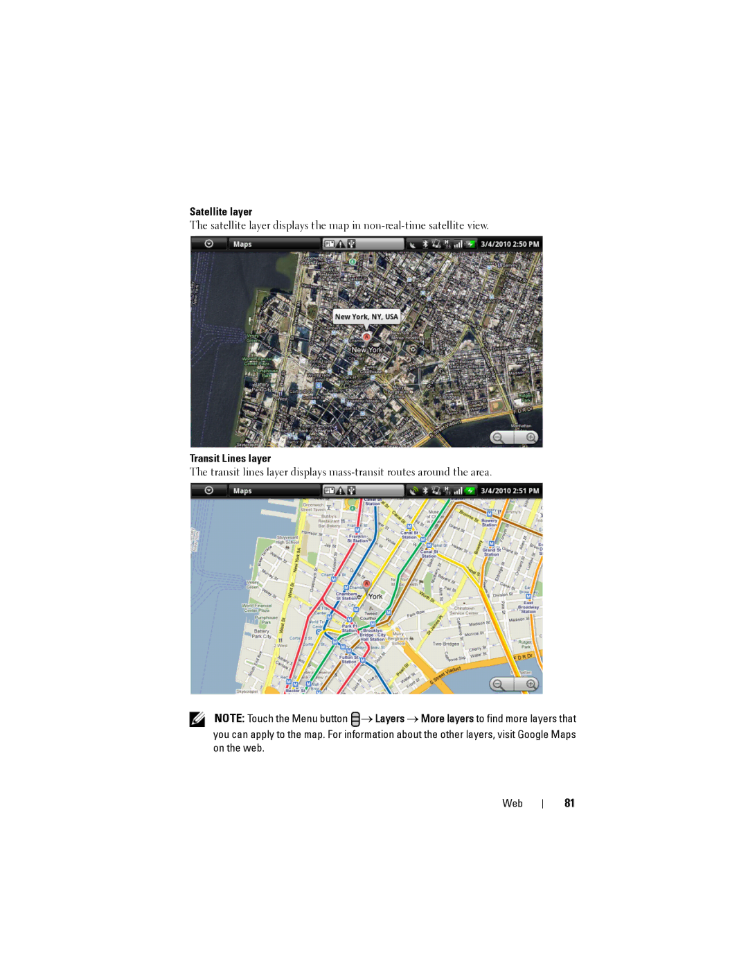
Transit Lines layer
Satellite layer
To get directions
To view a map in street view
To clear a map
To run Latitude
Using Google Latitude
To invite friends to share locations
Touch Add friends then Yes
To show your friends
To accept an invitation
Map view
List view
To control what to share and change your public profile
Edit privacy setting
Sharing options
Remove this friend
YouTube
To search for a video by voice command
To open YouTube
To search for a video by typing
To filter videos by different time frames
To search for a video by category
To watch videos
To manage a video
To open Android Market
Android Market
Share
Flag
Android Market screen opens
To download and install an application or game
Touch Uninstall
To uninstall an application or game
Synchronizing Your Google Data
To open an application or game
Amazon MP3
Customizing Your Dell Streak
To change display settings
Screen timeout
To change sound and ringtone settings
To manually set the date, time and time zone
Set date
Select time source
Set time zone
Set time
Select locale
To choose a language
Protect Your Device Data With a Screen Unlock Pattern
Protecting Your Dell Streak
Touch Forgot pattern
To create a screen unlock pattern
100
Protect Your SIM Card With the SIM Lock Password
To enable the SIM card PIN
101
102
To change the SIM card PIN
Camera
Applications
104
To manage pictures
105
106
To adjust camera settings
Edit
Set as
To capture videos
To adjust video settings
To play videos
107
To manage videos
MicroSD
To set the microSD card as a USB drive
108
To turn off USB storage
Touch Turn off USB storage→ Turn Off
109
To turn on Bluetooth and make the device discoverable
Bluetooth
To pair and connect a Bluetooth headset
110
To terminate a pairing partnership
To end a Bluetooth connection
To change your device’s Bluetooth name
111
To view pictures
Photos and Videos
To manage a picture
112
To mark pictures and videos
→ Mark
113
To open Music
Music
To select a song
114
115
To control music playback
116
To create a playlist
Calendar
To set up an event
To open the calendar
To view the calendar
To open the alarm clock
Alarm Clock
Event reminders
To view, dismiss, or snooze a reminder
Turn on alarm
To set an alarm
To temporarily disable an alarm
To delete an alarm
Calculator
Recorder
120
Voice Control
To say a voice command to start an action
To adapt the device to your voice
121
Outlook Tasks
To add a task
122
SIM Manager
To adjust task settings
To manage a task reminder
123
Quickoffice
Outlook Notes
To view a document or spreadsheet
To sort folders or files using Quickoffice
To find text in a document
125
126
Connect to a Computer and Install Dell PC Suite
To synchronize using Sync Manager
Using Dell PC Suite
To back up or restore device data using Backup Manager
To quit Dell PC Suite
128
Playing Videos on Hdmi Devices
129
Troubleshooting
130
Problem Possible causes Possible solutions
131
System problems
132
Messaging problems
Internet problems
Media problems
133
134
Start emergency software recovery
If necessary, you can calibrate your touch screen as follows
135
136
Index
137
138
PIN
139
140