(2) PIutMode
To enterthe Plot Mode. chooseKey #2 from the Menu ScreenThe. Star Pilot displaywill startby usingthe lastPlot Modedataancl destination.
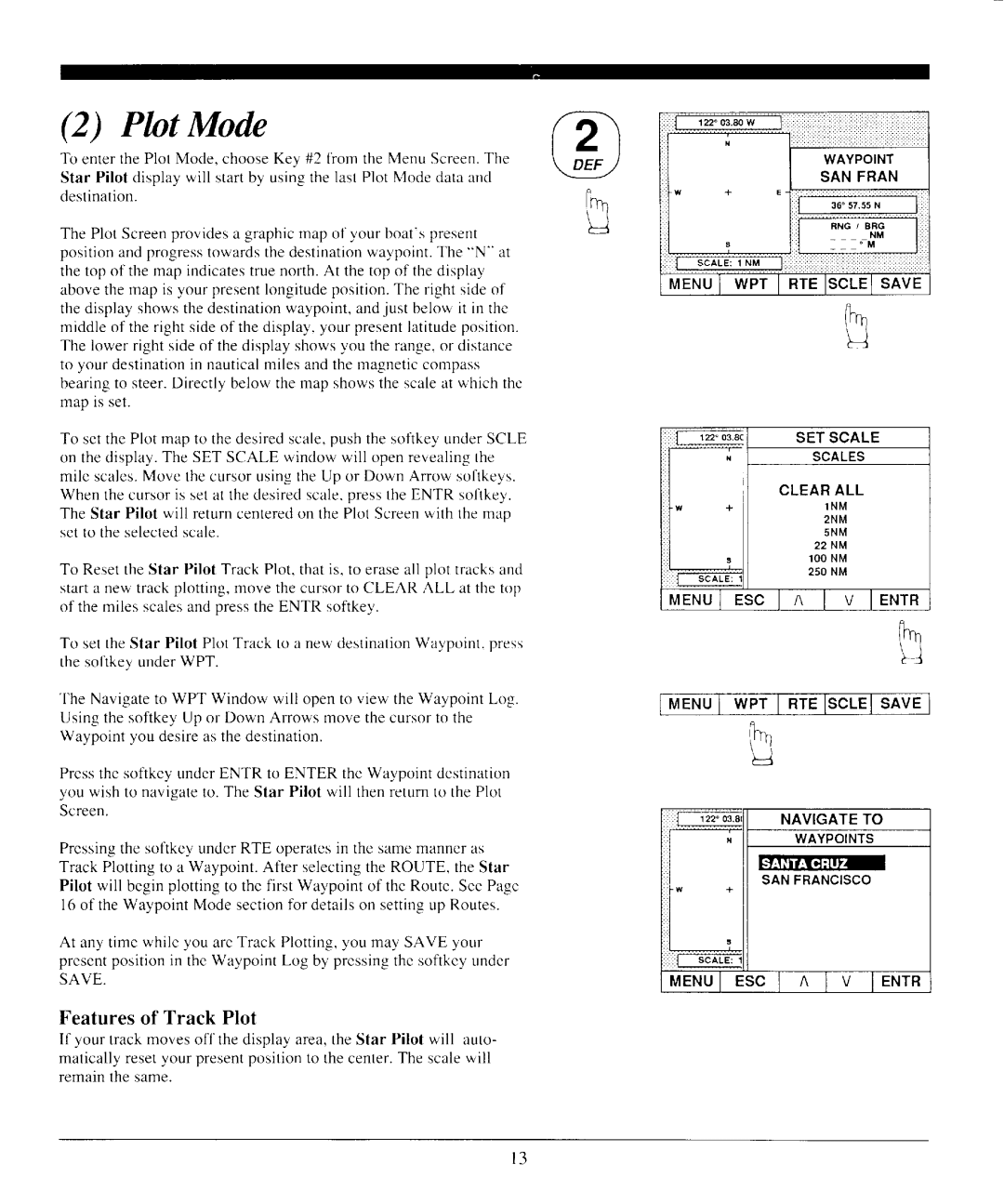
The Plot Screenprovidesa graphicmap of your boat'spresent positionandprogresstowardsthedestinationwaypoint.The "N" at thetop of themap indicatestruenorth.At thetop of thedisplay abovethemap is your presentlongitudeposition.The right sideof thedisplayshowsthedestinationwaypoint,andjust belowit in thc middleof theright sideof thedisplay,your presentlatitudeposition. The lowerright sideof thedisplayshowsyou therange.or distance to your destinationin nauticalmilesandthemagneticcompass bearingto steer.Directly below the map showsthe scaleat which thc map is set.
To setthePlotmap to thedesiredscale,pushthe sofikeyunderSCLE on thedisplay.The SET SCALE window will openrevealingthe mile scalesMove. thecursorusingthe Up or Down Arrow softkeys. Whenthecursoris setat thedesiredscalepress.theENTR sofikey. The Star Pilot will returncenteredon the Plot Screenwith themap setto theselectedscale.
To ResettheStar Pilot TrackPlot,thatis, to eraseall plot tracksand starta new trackplotting,move the cursorto CLEAR ALL at thc top of themilesscalesandpresstheENTR softkey.
To settheStar Pilot PlotTrackto a new destinationWavpoint.oress the sofikeyunderWPT.
The Navigateto WPT Window will opento view theWaypointLog. Usingthe softkeyUp or Down Arrows movethecursorto the Waypointyou desireasthedestination.
Pressthe sofikey underENTR to ENTER the Waypointdestination you wish to navigateto. The Star Pilot will thenreturnto the Plot Screen.
Pressingthe sofikeyunderRTE operatesin the samemanneras Track Plottingto a Waypoint.After selectingthe ROUTE. the Star Pilot will beginplottingto the first Waypointof the Route.SeePa_ee l6 of theWaypointMode sectionfbr detailson settingup Routes.
At any time while you areTrackPlotting,you may SAVE your presentpositionin theWaypointLog by pressingthesoftkeyunder SAVE.
Featuresof Track Plot
If your trackmovesoff the displayarea,the Star Pilot will auto- maticallyresetyour presentpositionto thecenterThe. scalewill remainthe same.
S C A L E S
C L E A RA L L
1 N M
2 N M
5 N M
2 2 N M lOONM 250 NM
M E N U IE S C I n I v I E N T R
R
Irfn
l 3
