HV301
Inhaltsverzeichnis
Unbedingt beachten
Geräteelemente
Inbetriebnahme
Rotationsmodus
Punktmodus
Linienmodus
Nivelliergenauigkeit
Manuellbetrieb/Einachsen-Neigungsbetrieb
Nivellierautomatik, Trittsicherung
Arbeitsbeispiele
Genauigkeitsüberprüfung
Meterriß/Höhenpunkt übertragen
Parallel ausrichten
Rechten Winkel antragen/Vertikalbetrieb
Bodenpunkt an Decke übertragen Lot
Wandhalterung M300 optional
Stromversorgung
Geräteschutz
Reinigung UND Pflege
Umweltschutz
Garantie
Technische Daten
Konformitätserklärung
Table of Contents
Setting to Work
Rotation mode
Pointing mode
Components
Leveling Accuracy
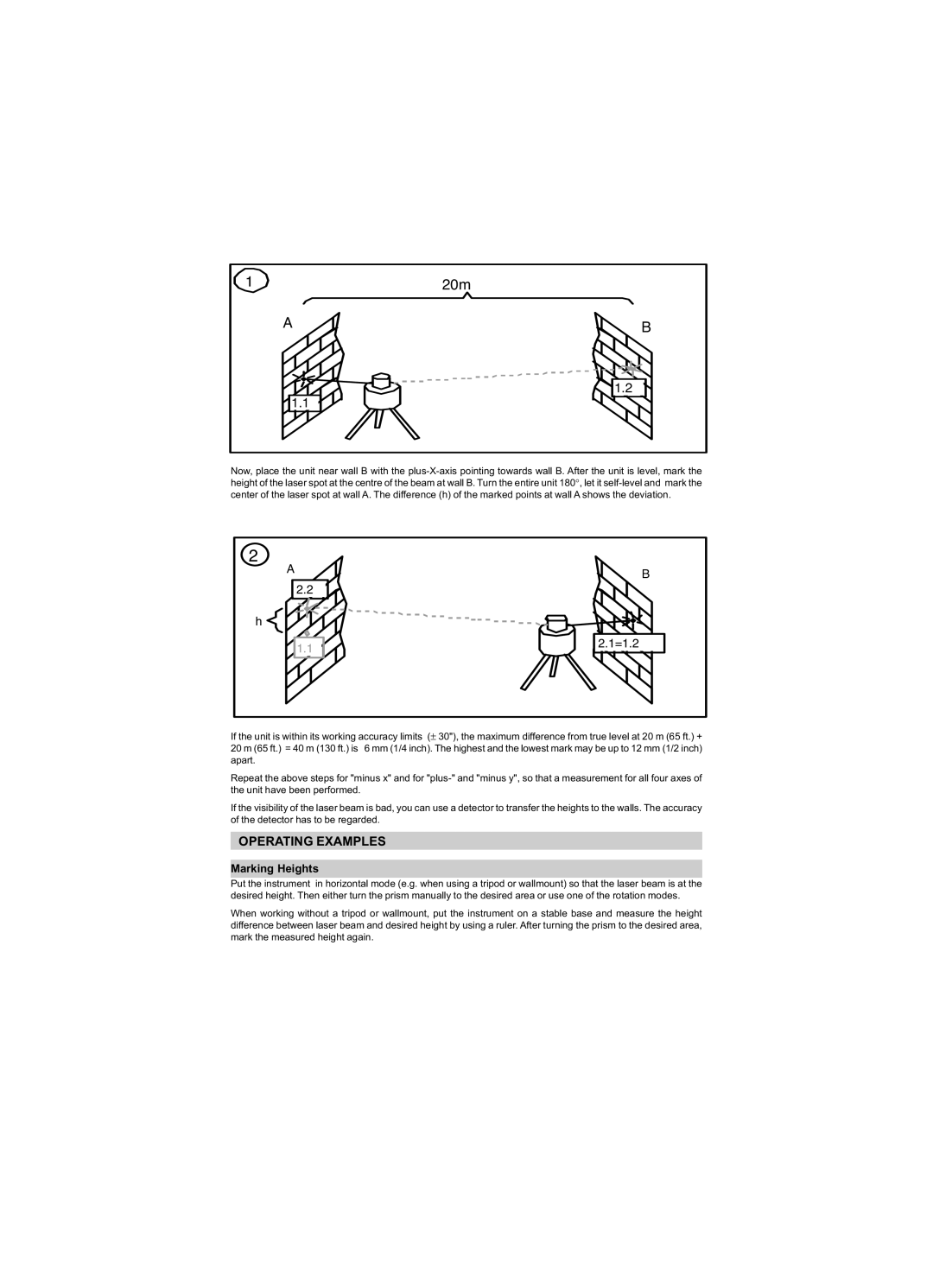
Operating Examples
Marking Heights
Adjusting in Parallel
Right Angles/Vertical Mode
Wall Mount M300 optional
Transferring marks to the Ceiling Plumb Point
Power Supply
Cleaning and Maintenance
Protecting the Unit
Protecting the Environment
Warranty
Technical Data
Declaration of Conformity
Electro-Magnetic Compatibility Declaration of Conformity
Sommaire
Respecter impérativement
Mise EN Service
Mode de rotation
Mode de point
Elements DE L’APPAREIL
Mode de ligne
Mode manuel/mode de nivellement à un axe
Precision DE Nivellement
Nivellement automatique, sécurité de marche
Exemples DE Travail
Contrôle de la précision
Transcription du tracé de mètre/point de hauteur
Orientation parallèle
Marquage de l’angle droit/mode vertical
Marquage du point de sol au plafond plomb
Fixation murale M300 en option
Alimentation EN Courant
Protection DE L’APPAREIL
Nettoyage ET Entretien
Protection DE L’ENVIRONNEMENT
Caracteristiques Techniques
Déclaration de conformité
Indice
Attenzione osservare assolutamente
Elementi DELL’APPARECCHIO
Messa in Funzione
Modalità di rotazione
Modalità punto
Esattezza DI Livellamento
Modalità linea
Funzionamento manuale/Funzionamento inclinato ad un asse
Automatica di livellamento, Sicurezza passo
Esempi DI Lavoro
Controllo dell’esattezza
Strappo metro/trasmettere punto culminante
Raddrizzare in maniera parallela
Inserimento angolo retto/funzionamento verticale
Trasferire il punto del pavimento al soffitto piombo
Fissaggio a muro M300 opzionale
Alimentazione
Protezione DELL’APPARECCHIO
Pulizia E Cura
Protezione DELL’AMBIENTE
Garanzia
Dati Tecnici
Dichiarazione di conformità
Índice
Tener en cuenta obligatoriamente
Puesta EN Marcha
Modo de rotación
Modo de puntos
Precisión DE Nivelación
Modo lineal
Modo manual/Modo de inclinación de un eje
Sistema automático de nivelación, aviso de cambio de altura
Ejemplos DE Trabajo
Comprobación de la precisión
Transferir la fisura métrica/el punto de altura
Alinear un paralelo
Anotar un ángulo recto/Modo de funcionamiento vertical
Transferir el punto del fondo al techo/línea vertical
Soporte para pared M300 opcional
Alimentación DE Corriente
Protección DEL Aparato
Limpieza Y Cuidado
Protección DEL Medio Ambiente
Garantía
Datos Técnicos
Declaración de conformidad
Inhoudsopgave
Voor UW Veiligheid
Beslist in acht nemen
Onderdelen
Inbedrijfstellling
Rotatiemodus
Puntmodus
Waterpasnauwkeurigheid
Lijnmodus
Handmatig instellen / éénas-hellingmodus
Waterpasautomaat, slipbeveiliging
Werkvoorbeelden
Nauwkeurigheidscontrole
Meterpeil / hoogtepunt overbrengen
Parallel justeren
Rechte hoek aangeven / verticale werking
Bodempunt op plafond overbrengen / lood
Wandhouder M300 optioneel
Stroomvoorziening
Apparaatbeveiliging
Reiniging EN Onderhoud
Milieubescherming
Technische Gegevevens
Overeenstemmingsverklaring
Innehållsförteckning
Mycket viktigt
Idrifttagning
Rotationsläge
Punktläge
Avvägningsnoggrannhet
Linjeläge
Manuell drift/enaxel-lutningsdrift
Automatisk avvägning, stegsäkring
Arbetsexempel
Noggrannhetskontroll
Överföra metermärke/höjdpunkt
Parallell inriktning
Märka in rät vinkel / vertikaldrift
Överföra golvpunkt till taket lod
Väggfäste M300 tillval
Strömförsörjning
Apparatskydd
Rengöring OCH Skötsel
Miljöskydd
Garanti
Tekniska Data
Försäkran om överensstämmelse
Indholdsfortegnelse
Skal ubetinget følges
Apparatdele
Ibrugtagning
Taster på betjeningsfeltet
Kontrolindikatorer
Nivelleringsnøjagtighed
Liniemodus
Manuel anvendelse/enakset hældning
Nivelleringsautomatik og trinsikring
Arbejdseksempler
Nøjagtighedskontrol
Overføring af meterrids/højdepunkt
Parallel indstilling
Afsætning af ret vinkel/lodret anvendelse
Overføring af gulvpunkt til loft lod
Vægholder M300 ekstra tilbehør
Strømforsyning
Beskyttelse AF Apparatet
Rengøring OG Pleje
Miljøbeskyttelse
Tekniske Data
Overensstemmelseserklæring
Observar obrigatoriamente
Para a SUA Segurança
Elementos do Aparelho Colocação EM Funcionamento
Exemplos DE Trabalhos
Elementos do Aparelho
Colocação EM Funcionamento
Modo rotacional
Modo punctual
Exactidão DE Nivelação
Modo linear
Operação manual/Operação de inclinação sobre um eixo
Automática de nivelação, segurança de entrada
Exemplos DE Trabalho
Verificação da exactidão
Transferir a fissura métrica/ponto de altura
Alinhar paralelamente
Aplicar em ângulo recto/Modo operacional vertical
Tranferir o ponto do solo para o tecto Prumo
Suporte de parede M300 opcional
Alimentação DE Corrente
Protecção do Aparelho
Limpeza E Conservação
Protecção AO Meio Ambiente
Garantia
Dados Técnicos
Declaração de conformidade
Innholdsfortegnelse
TIL DIN Sikkerhet
Ta ubetinget hensyn til
Apparatelementene
Igangsetning
Rotasjonsmodus
Nivelleringsnøyaktighet
Linjemodus
Manuell drift/enakset-krengningsdrift
Nivelleringsautomatikk, trinnsikring
Arbeidseksempler
Nøyaktighetskontroll
Overføre meterrisset/høydepunket
Justere parallelt
Anlegge den høyre vinkelen/vertikaldrift
Overføre gulvpunktet til taket lodd
Veggholdeinnretning M300 opsjon
Apparatvern
Rengjøring OG Pleie
Miljøvern
Konformitetserklæring
Sisältö FIN
Huomioitava ehdottomasti
LAITE-ELEMENTIT
Käyttöönotto
Rotaatiomodus
Pistemodus
Vaakitustarkkuus
Linjamodus
Manuaalikäyttö/Yksiakselinen kaltevuuskäyttö
Vaakitusautomaatti, askelvaroke
Työesimerkit
Tarkkuuskontrolli
Metrihalkeama/Korkeuskohdan siirto
Rinnakkaiskohdistus
Oikean kulman kiinnitys/pystysuorakäyttö
Pohjapisteen siirto sisäkattoon juote
Seinäkiinnitys M300 vaihtoehtoinen
Virransaanti
Patterien/akkujen käyttö
Käyttöaika
Akkujen lataus
Takuu
Tekniset Tiedot
Yhteensopivuusilmoitus
Ðéíáêáó ÐÅÑÉÅ×ÏÌÅÍÙÍ
ÃÉÁ ÔÇÍ Áóöáëåéá ÓÁÓ
ÐñïóÝ÷åôå áðáñáéôÞôùò
Ìåñç Óõóêåõçó
Èåóç ÓÅ Ëåéôïõñãéá
Ðåñéóôñïöéêüò ôñüðïò ëåéôïõñãßáò
Óçìåéáêüò ôñüðïò ëåéôïõñãßáò
Ãñáììéêüò ôñüðïò ëåéôïõñãßáò
×åéñïêßíçôç ëåéôïõñãßá/ëåéôïõñãßá êëßóçò åíüò Üîïíá
Áõôüìáôç äéÜôáîç ÷ùñïóôÜèìçóçò, áóöÜëåéá êëßóçò
Áêñéâåéá ×ÙÑÏÓÔÁÈÌÇÓÇÓ
¸ëåã÷ïò áêñßâåéáò
ÔñåìïöÝîéìï ðÜíù óå êáõôïýò áóöáëôïóôñùìÝíïõò äñüìïõò
Ðáñáäåéãìáôá Åñãáóéáó
ÌåôáöïñÜ ôïõ óçìåßïõ áíáöïñÜò/ýøïõò
ÐáñÜëëçëç åõèõãñÜìéóç
Êáèïñéóìüò ïñèÞò ãùíßáò/êÜèåôç ëåéôïõñãßá
ÓõãêñáôÞñáò ôïß÷ïõ M300 êáô’ åðéëïãÞí
Ôñïöïäïóéá ÉÓ×ÕÏÓ
ÔïðïèÝôçóç ìðáôáñéþí
ÄéÜñêåéá ëåéôïõñãßáò
Öüñôéóç ôùí ìðáôáñéþí
Ðñïóôáóéá ÔÇÓ Óõóêåõçó
Êáèáñéóìïó ÊÁÉ Óõíôçñçóç
Ðñïóôáóéá ÔÏÕ Ðåñéâáëëïíôïó
ÔÅ×ÍÉÊÁ ×ÁÑÁÊÔÇÑÉÓÔÉÊÁ
ÄÞëùóç óõìâáôéêüôçôáò
Ýçerýk
Güvenlýðýnýz Ýçýn
Mutlaka dikkat ediniz
Alet Elemanlari
Ýþletme
Dönme tarzý
Nokta tarzý
Çizgi tarzý
El ile iþletme/Tek eksen Eðilim iþletmesi
Tesviye otomatiði, Yüzdürme emniyeti
Tesvýye Hassasýyetý
Hassasiyet kontrolü
Çaliþma Örneklerý
Metre çatlaðý/Yükseklik noktasýný aktarmak
Paralel ayarlamak
Dik açýyý iþaretlemek/Dikey iþletme
Zemin noktasýný tavana aktarmak Dik çizgi
Duvar tutucusu M300 opsiyonal
Akim Beslemesý
Alet Korumasi
Temýzlýk VE Bakim
Çevre Korumasi
Garantý
Teknýk Býlgýler
Uyarlýk açýklamasý