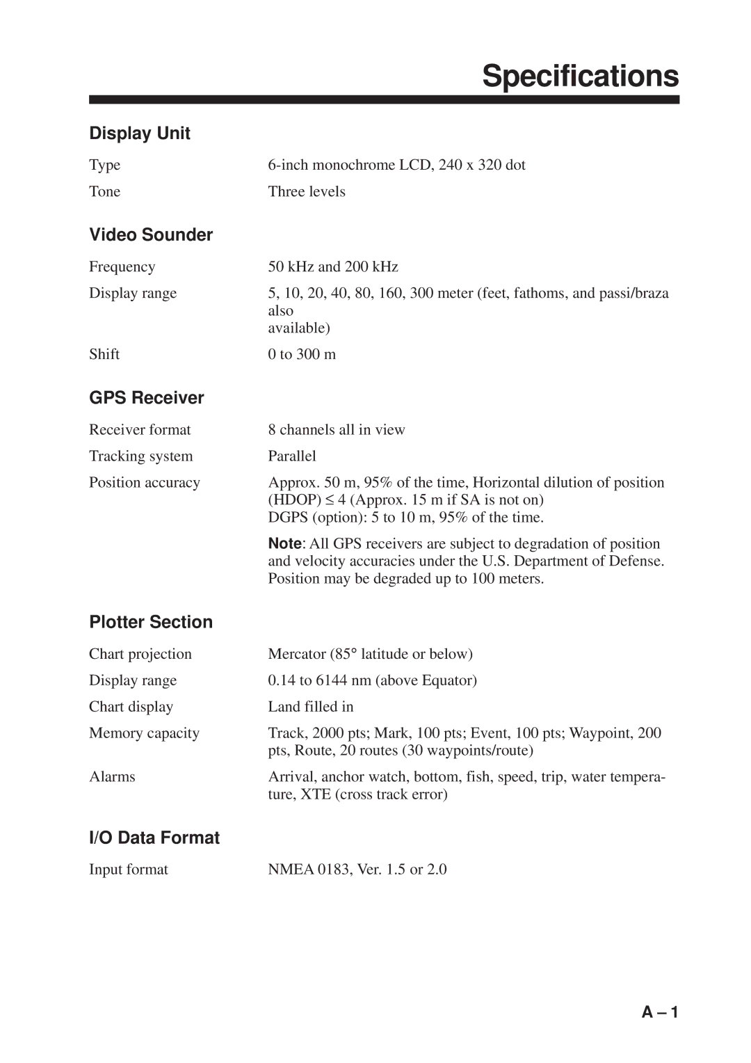
GP-1600F specifications
The Furuno GP-1600F is an innovative marine GPS chart plotter designed for the serious boating enthusiast or commercial mariner. This advanced device combines reliable positioning accuracy with a range of user-friendly features, making it a popular choice for those navigating both coastal and offshore waters.One of the standout features of the GP-1600F is its high-resolution color display. The 6.5-inch screen provides a clear and vibrant view of maps and navigational data, ensuring that users can quickly interpret information at a glance even in bright sunlight. The user interface is intuitive, enabling both novice and experienced users to operate the device effortlessly.
The GP-1600F incorporates advanced GPS technology, providing incredibly precise positioning capabilities. With a high-sensitivity GPS receiver and Fast Acquisition Technology, the unit is designed to lock onto satellites quickly, even in challenging environments. The built-in WAAS (Wide Area Augmentation System) receiver further enhances accuracy, ensuring that boaters can navigate with confidence.
One of the notable features of the GP-1600F is its ability to integrate seamlessly with other Furuno marine electronics. This capability allows users to expand their system with additional components, such as radar or fish finders, creating a comprehensive navigation solution. The ability to share data between devices enhances situational awareness and allows for more informed decision-making on the water.
The GP-1600F also comes equipped with advanced charting capabilities. Users can access a variety of maps and navigational charts, including vector and raster formats, to suit their specific needs. The unit supports C-MAP and Navionics chart formats, providing flexibility for different boating environments. This versatility makes it an excellent option whether you are cruising on a lake, sailing in coastal waters, or engaging in offshore adventures.
In terms of durability, the GP-1600F is built to withstand the harsh marine environment. It comes with a rugged housing that is both waterproof and resistant to saltwater corrosion, ensuring reliability in all conditions. The unit's design also includes a user-replaceable fuse, making maintenance straightforward and cost-effective.
Overall, the Furuno GP-1600F is a robust and feature-rich marine GPS chart plotter that combines advanced technology with practical usability. Its high-resolution display, precise GPS capabilities, integration options, and durable construction make it an ideal choice for any serious mariner looking to enhance their on-water navigation experience. Whether for leisure boating or professional use, the GP-1600F stands out as an essential tool for safe and informed navigation.
