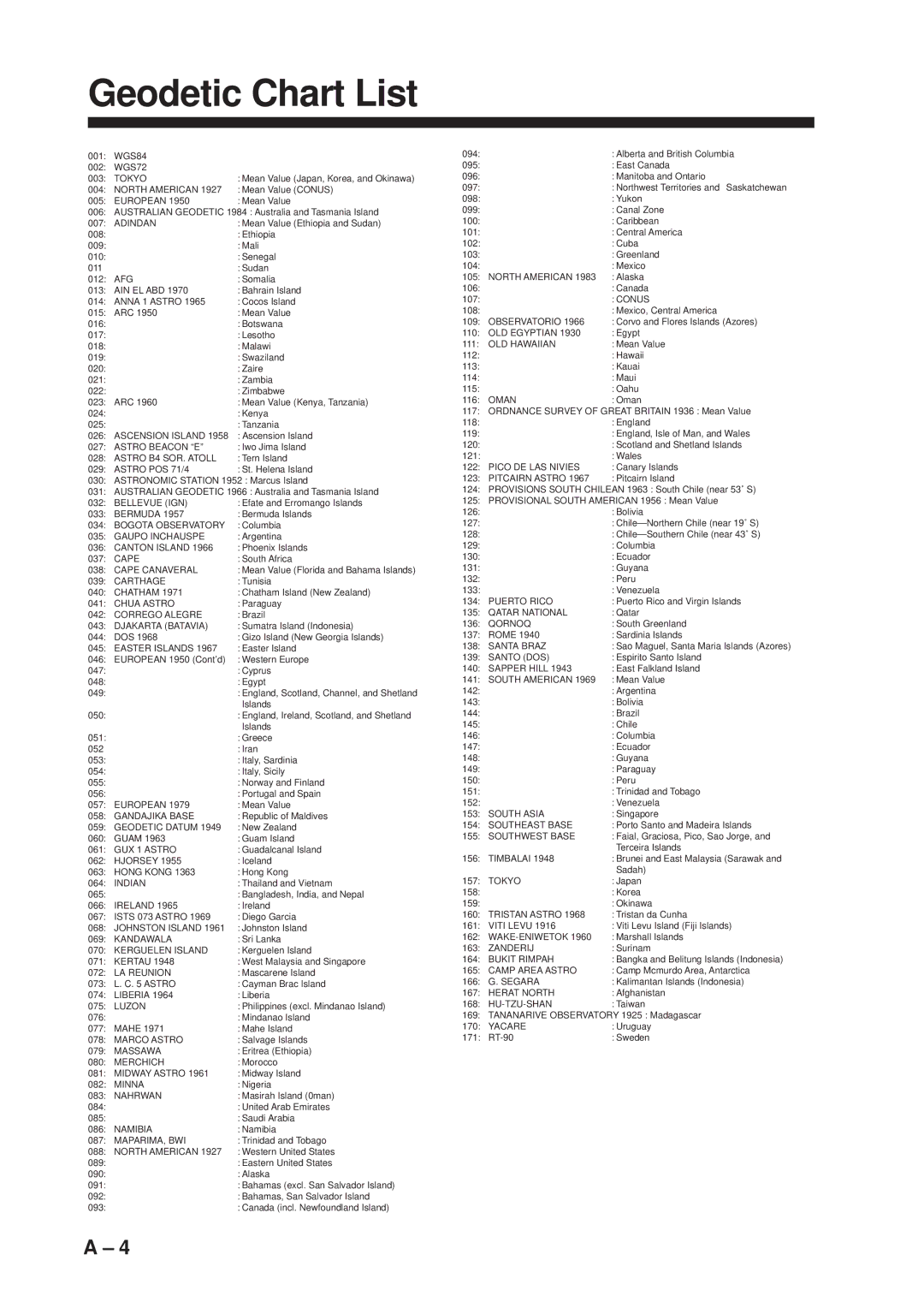
Geodetic Chart List

001:

WGS84


002:

WGS72


003:

TOKYO

: Mean Value (Japan, Korea, and Okinawa)

004:

NORTH AMERICAN 1927

: Mean Value (CONUS)

005:

EUROPEAN 1950

: Mean Value

006: AUSTRALIAN GEODETIC 1984 : Australia and Tasmania Island

007:

ADINDAN

: Mean Value (Ethiopia and Sudan)

008:


: Ethiopia

009:


: Mali

010:


: Senegal

011


: Sudan

012:

AFG

: Somalia

013:

AIN EL ABD 1970

: Bahrain Island

014:

ANNA 1 ASTRO 1965

: Cocos Island

015:

ARC 1950

: Mean Value

016:


: Botswana

017:


: Lesotho

018:


: Malawi

019:


: Swaziland

020:


: Zaire

021:


: Zambia

022:


: Zimbabwe

023:

ARC 1960

: Mean Value (Kenya, Tanzania)

024:


: Kenya

025:


: Tanzania

026:

ASCENSION ISLAND 1958

: Ascension Island

027:

ASTRO BEACON “E”

: Iwo Jima Island

028:

ASTRO B4 SOR. ATOLL

: Tern Island

029:

ASTRO POS 71/4

: St. Helena Island

030: ASTRONOMIC STATION 1952 : Marcus Island

031: AUSTRALIAN GEODETIC 1966 : Australia and Tasmania Island

032:

BELLEVUE (IGN)

: Efate and Erromango Islands

033:

BERMUDA 1957

: Bermuda Islands

034:

BOGOTA OBSERVATORY

: Columbia

035:

GAUPO INCHAUSPE

: Argentina

036:

CANTON ISLAND 1966

: Phoenix Islands

037:

CAPE

: South Africa

038:

CAPE CANAVERAL

: Mean Value (Florida and Bahama Islands)

039:

CARTHAGE

: Tunisia

040:

CHATHAM 1971

: Chatham Island (New Zealand)

041:

CHUA ASTRO

: Paraguay

042:

CORREGO ALEGRE

: Brazil

043:

DJAKARTA (BATAVIA)

: Sumatra Island (Indonesia)

044:

DOS 1968

: Gizo Island (New Georgia Islands)

045:

EASTER ISLANDS 1967

: Easter Island

046:

EUROPEAN 1950 (Cont’d)

: Western Europe

047:


: Cyprus

048:


: Egypt

049:


: England, Scotland, Channel, and Shetland


Islands

050:


: England, Ireland, Scotland, and Shetland


Islands

051:


: Greece

052


: Iran

053:


: Italy, Sardinia

054:


: Italy, Sicily

055:


: Norway and Finland

056:


: Portugal and Spain

057:

EUROPEAN 1979

: Mean Value

058:

GANDAJIKA BASE

: Republic of Maldives

059:

GEODETIC DATUM 1949

: New Zealand

060:

GUAM 1963

: Guam Island

061:

GUX 1 ASTRO

: Guadalcanal Island

062:

HJORSEY 1955

: Iceland

063:

HONG KONG 1363

: Hong Kong

064:

INDIAN

: Thailand and Vietnam

065:


: Bangladesh, India, and Nepal

066:

IRELAND 1965

: Ireland

067:

ISTS 073 ASTRO 1969

: Diego Garcia

068:

JOHNSTON ISLAND 1961

: Johnston Island

069:

KANDAWALA

: Sri Lanka

070:

KERGUELEN ISLAND

: Kerguelen Island

071:

KERTAU 1948

: West Malaysia and Singapore

072:

LA REUNION

: Mascarene Island

073:

L. C. 5 ASTRO

: Cayman Brac Island

074:

LIBERIA 1964

: Liberia

075:

LUZON

: Philippines (excl. Mindanao Island)

076:


: Mindanao Island

077:

MAHE 1971

: Mahe Island

078:

MARCO ASTRO

: Salvage Islands

079:

MASSAWA

: Eritrea (Ethiopia)

080:

MERCHICH

: Morocco

081:

MIDWAY ASTRO 1961

: Midway Island

082:

MINNA

: Nigeria

083:

NAHRWAN

: Masirah Island (0man)

084:


: United Arab Emirates

085:


: Saudi Arabia

086:

NAMIBIA

: Namibia

087:

MAPARIMA, BWI

: Trinidad and Tobago

088:

NORTH AMERICAN 1927

: Western United States

089:


: Eastern United States

090:


: Alaska

091:


: Bahamas (excl. San Salvador Island)

092:


: Bahamas, San Salvador Island

093:


: Canada (incl. Newfoundland Island)

094:


: Alberta and British Columbia

095:


: East Canada

096:


: Manitoba and Ontario

097:


: Northwest Territories and Saskatchewan

098:


: Yukon

099:


: Canal Zone

100:


: Caribbean

101:


: Central America

102:


: Cuba

103:


: Greenland

104:


: Mexico

105: NORTH AMERICAN 1983

: Alaska

106:


: Canada

107:


: CONUS

108:


: Mexico, Central America

109:

OBSERVATORIO 1966

: Corvo and Flores Islands (Azores)

110:

OLD EGYPTIAN 1930

: Egypt

111:

OLD HAWAIIAN

: Mean Value

112:


: Hawaii

113:


: Kauai

114:


: Maui

115:


: Oahu

116:

OMAN

: Oman

117: ORDNANCE SURVEY OF GREAT BRITAIN 1936 : Mean Value

118:


: England

119:


: England, Isle of Man, and Wales

120:


: Scotland and Shetland Islands

121:


: Wales

122:

PICO DE LAS NIVIES

: Canary Islands

123:

PITCAIRN ASTRO 1967

: Pitcairn Island

124:PROVISIONS SOUTH CHILEAN 1963 : South Chile (near 53˚ S)

125:PROVISIONAL SOUTH AMERICAN 1956 : Mean Value

126:


: Bolivia

127:


: Chile—Northern Chile (near 19˚ S)

128:


: Chile—Southern Chile (near 43˚ S)

129:


: Columbia

130:


: Ecuador

131:


: Guyana

132:


: Peru

133:


: Venezuela

134:

PUERTO RICO

: Puerto Rico and Virgin Islands

135:

QATAR NATIONAL

: Qatar

136:

QORNOQ

: South Greenland

137:

ROME 1940

: Sardinia Islands

138:

SANTA BRAZ

: Sao Maguel, Santa Maria Islands (Azores)

139:

SANTO (DOS)

: Espirito Santo Island

140:

SAPPER HILL 1943

: East Falkland Island

141: SOUTH AMERICAN 1969

: Mean Value

142:


: Argentina

143:


: Bolivia

144:


: Brazil

145:


: Chile

146:


: Columbia

147:


: Ecuador

148:


: Guyana

149:


: Paraguay

150:


: Peru

151:


: Trinidad and Tobago

152:


: Venezuela

153:

SOUTH ASIA

: Singapore

154:

SOUTHEAST BASE

: Porto Santo and Madeira Islands

155:

SOUTHWEST BASE

: Faial, Graciosa, Pico, Sao Jorge, and


Terceira Islands

156:

TIMBALAI 1948

: Brunei and East Malaysia (Sarawak and


Sadah)

157:

TOKYO

: Japan

158:


: Korea

159:


: Okinawa

160:

TRISTAN ASTRO 1968

: Tristan da Cunha

161:

VITI LEVU 1916

: Viti Levu Island (Fiji Islands)

162:

WAKE-ENIWETOK 1960

: Marshall Islands

163:

ZANDERIJ

: Surinam

164:

BUKIT RIMPAH

: Bangka and Belitung Islands (Indonesia)

165:

CAMP AREA ASTRO

: Camp Mcmurdo Area, Antarctica

166:

G. SEGARA

: Kalimantan Islands (Indonesia)

167:

HERAT NORTH

: Afghanistan

168: HU-TZU-SHAN

: Taiwan

169: TANANARIVE OBSERVATORY 1925 : Madagascar

170:

YACARE

: Uruguay

171:

RT-90

: Sweden

A – 4

Page 92
Image 92
Furuno GP-1600F manual Geodetic Chart List

GP-1600F specifications

The Furuno GP-1600F is an innovative marine GPS chart plotter designed for the serious boating enthusiast or commercial mariner. This advanced device combines reliable positioning accuracy with a range of user-friendly features, making it a popular choice for those navigating both coastal and offshore waters.

One of the standout features of the GP-1600F is its high-resolution color display. The 6.5-inch screen provides a clear and vibrant view of maps and navigational data, ensuring that users can quickly interpret information at a glance even in bright sunlight. The user interface is intuitive, enabling both novice and experienced users to operate the device effortlessly.

The GP-1600F incorporates advanced GPS technology, providing incredibly precise positioning capabilities. With a high-sensitivity GPS receiver and Fast Acquisition Technology, the unit is designed to lock onto satellites quickly, even in challenging environments. The built-in WAAS (Wide Area Augmentation System) receiver further enhances accuracy, ensuring that boaters can navigate with confidence.

One of the notable features of the GP-1600F is its ability to integrate seamlessly with other Furuno marine electronics. This capability allows users to expand their system with additional components, such as radar or fish finders, creating a comprehensive navigation solution. The ability to share data between devices enhances situational awareness and allows for more informed decision-making on the water.

The GP-1600F also comes equipped with advanced charting capabilities. Users can access a variety of maps and navigational charts, including vector and raster formats, to suit their specific needs. The unit supports C-MAP and Navionics chart formats, providing flexibility for different boating environments. This versatility makes it an excellent option whether you are cruising on a lake, sailing in coastal waters, or engaging in offshore adventures.

In terms of durability, the GP-1600F is built to withstand the harsh marine environment. It comes with a rugged housing that is both waterproof and resistant to saltwater corrosion, ensuring reliability in all conditions. The unit's design also includes a user-replaceable fuse, making maintenance straightforward and cost-effective.

Overall, the Furuno GP-1600F is a robust and feature-rich marine GPS chart plotter that combines advanced technology with practical usability. Its high-resolution display, precise GPS capabilities, integration options, and durable construction make it an ideal choice for any serious mariner looking to enhance their on-water navigation experience. Whether for leisure boating or professional use, the GP-1600F stands out as an essential tool for safe and informed navigation.