Leica TPS1200
Introduction
Purchase
Product identification
Trademarks
Symbols
Type Description
Introduction TPS1200
Table of Contents
Check & Adjust
Safety Directions 126
Care and Transport 120
Technical Data 168
Table of Contents TPS1200
Index 216
Validity of this
How to Use this Manual TPS1200
Index
Manual Models are marked and described
General description
How to Use this Manual
GPS1200
Main components
System Components
Description of the System TPS1200
Component Description
Terminology
Term Description
Description of the System
EGL
ATR
Antenna for a communication device and Communication side
Instrument models Model Description
Leica Geo Office
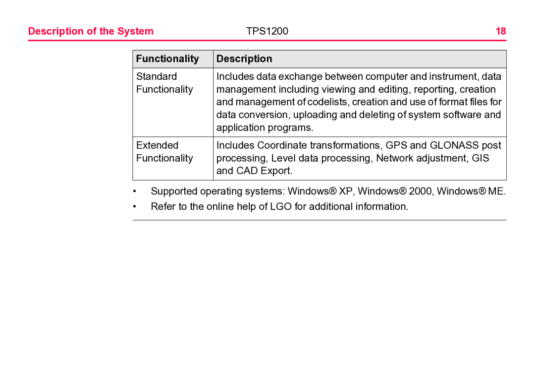
Functionality Description
System Concept
Software Concept
Software type Description
Application
Data Storage and Data Conversion Concept
Memory device
Data conversion Transfer raw data to LGO Export
Import
General
Power Concept
Power options Instrument
SmartAntenna
Container Contents
Container for Instrument and a delivered accessories part 2
Container for SmartStation/RCS components part 1
Container for SmartStation/RCS a Components b part 2
Instrument Components
Components Part 1
Instrument Components Part 2
Instrument components for SmartStation
RCS
Keyboard
User Interface TPS1200
Keyboard
CE, ESC, USER, Prog Shift Enter
Keys Description
User Interface
Pages up
Screen
Elements Description Screen
User key
Element Description
ESC
Step Description
Operating Principles
Turn instrument on Turn instrument off step-by-step
Lock/Unlock keyboard Option Description
Selecting a Appearance Description
Appearance Description
Highlight the field
Closed choicelist Appearance Description Selection
Simple listbox Appearance Description Selection
Listbox dialog Appearance Description Selection
Icons
Shift
TPS specific icons
Icon Description
Reflector
GPS specific icons Icon Description
RCS settings are displayed
Satellites Currently computed position solution
Compensator off, out of range or face I&II icon is
Considered to be too noisy to be used
Position solution
Or the observations to these satellites are
Real-time device
Battery
Icon Description CompactFlash
Quick coding
User Interface TPS1200
Instrument Setup
Operation TPS1200
Fasten the tribrach and instrument onto the tripod
Operation TPS1200
Adapter
Clip-on housing
Autodetect Behaviour
Radio/Modem
Status SmartStation menu RadioHandle
Instrument Setup as SmartStation
SmartStation Setup
Setup step-by-step Step Description
Step Description
TPS12195
TPS12209
LED Indicators on SmartAntenna
LED Indicators Description
Diagram of LED Indicators
Description of LED Indicators
Then
Working with the Clip-On-Housings for Devices
Radios fitting into a clip-on-housing Clip-on-housing
Attach a clip-on-housing
Detach a clip-on-housing Step Description
Operation TPS1200
Remove a SIM card step-by-step
LED Indicators on Clip-On-Housings
Diagram of the LED Indicators
Description of the LED Indicators
LED
GFU25 can
Short break Progress Off Device is off
PDL
Instrument Setup for Remote Control
Remote Control Setup
Setup step-by-step
Operation TPS1200
LED Indicators on RadioHandle
LED Indicators
Then
Battery
Operating Principles
Primary use/charging
Operation/Discharging
Instrument Battery
Operation TPS1200
SmartAntenna Battery
Change battery Step-by-step
Operation TPS1200
Working with the CompactFlash Card
Insert and remove
Format a
TPS1200
Format Method Format Quick
Operation TPS1200 Step Description
Main Menu Tools...\Format Memory Device
Tools Format Memory Device
Accessing Survey Application Program
Access Select Main Menu Survey
Survey Begin
Coord System
Config Set
Field Option Description Job
Codelist
Add. Constant
Field Option Description
Main Menu Manage...\Reflectors. All listed
Next step
Guidelines for Correct Results
Operation TPS1200
ATR/lock
Operation TPS1200
Check & Adjust TPS1200
Overview
Adjustment
View current
Check & Adjust TPS1200
Proper adjust
Ment
Page
Next step If the task is to
Combined Adjustment l, t, i, c and ATR
Telescope face
Tools Adjustment Accuracy
Second run onwards
Check & Adjust TPS1200 100
Next step If the results are
Tilting Axis Adjustment a
Check & Adjust TPS1200 101
Check & Adjust TPS1200 102
Step Description Tools Tilting-Axis Adjustment
Check & Adjust TPS1200 103
Check & Adjust TPS1200 104
Step Description Tools T-Axis Adjustment Accuracy
Check & Adjust TPS1200 105
Adjustment of the Circular Level
Check & Adjust TPS1200 106
Check & Adjust TPS1200 107
On the tribrach step-by-step
Check & Adjust TPS1200 108
Adjustment of the Reflectorless EDM
Precautions
Check & Adjust TPS1200 109
Check & Adjust TPS1200 110
Check & Adjust TPS1200 111
Direction of the beam step-by-step
Check & Adjust
Adjusting Direction Beam step-by-step
Check & Adjust TPS1200 113
Adjustment of the Laser Plummet
Check & Adjust TPS1200 114
Check & Adjust TPS1200 115
Inspecting laser Plummet Step-by-step
Check & Adjust TPS1200 116
Check & Adjust TPS1200 117
Service of the Tripod
Check & Adjust TPS1200 118
Service tripod Step-by-step
Check & Adjust TPS1200 119
Transport
Care and Transport TPS1200
Care and Transport TPS1200 121
Care and Transport TPS1200 122
Field adjustment
Storage
Product
Cleaning and Drying
Care and Transport TPS1200 123
Maintenance
Care and Transport TPS1200 124
Motorisation
Care and Transport TPS1200 125
Safety Directions TPS1200 126
General Introduction
Permitted use
Safety Directions
Intended Use
Adverse use
Safety Directions TPS1200 128
Safety Directions TPS1200 129
Limits of Use
Environment
Safety Directions TPS1200 130
Responsibilities
International Warranty, Software Licence Agreement
131
Safety Directions TPS1200 132
Safety Directions TPS1200 133
Hazards of Use
Safety Directions TPS1200 134
Safety Directions TPS1200 135
Safety Directions TPS1200 136
Safety Directions TPS1200 137
Safety Directions TPS1200 138
Regulations in force in your country
Safety Directions TPS1200 139
Laser Classification
Integrated Distancer, Invisible Laser
140
Description Value
Safety Directions TPS1200 141
Labelling
Safety Directions TPS1200 142
Integrated Distancer, Visible Laser
Safety Directions TPS1200 143
Description R100 R300
144
Safety Directions TPS1200 145
Safety Directions TPS1200 146
Labelling
Safety Directions TPS1200 147
Safety Directions TPS1200 148
Automatic Target Recognition ATR
Safety Directions TPS1200 149
PowerSearch PS
Safety Directions TPS1200 150
Safety Directions TPS1200 151
Safety Directions TPS1200 152
Electronic Guide Light EGL
Flashing LED Yellow Red
Safety Directions TPS1200 153
Safety Directions TPS1200 154
Laser Plummet
Safety Directions TPS1200 155
Ulars or telescopes
Do not look directly into the beam with optical equipment
Safety Directions
Safety Directions TPS1200 157
Safety Directions TPS1200 158
Electromagnetic Compatibility EMC
Safety Directions TPS1200 159
160
Radios, digital
Safety Directions TPS1200 161
FCC Statement, Applicable in U.S
Applicability
Safety Directions TPS1200 162
Labelling TPS1200
Safety Directions TPS1200 163
Labelling SmartAntenna
Safety Directions TPS1200 164
Labelling clip-on-housings GFU17 and GFU24
Safety Directions TPS1200 165
Labelling internal battery GEB211, GEB221
TPS1200166
Safety Directions TPS1200 167
Labelling RadioHandle
Technical Data TPS1200 168
Characteristics
Angle Measurement
Technical Data TPS1200 169
Distance Measurement Infrared IR
Range Reflector Range a Range B Range C
Technical Data TPS1200 170
Accuracy
Technical Data TPS1200 171
Range
Technical Data TPS1200 172
Distance Measurement Reflectorless RL
Type Kodak Gray Range D Range E Range F Card
Technical Data TPS1200 173
Technical Data
174
Laser dot size Distance m
Atmospheric
Technical Data TPS1200 175
Distance Measurement Long Range LO
Conditions
Technical Data TPS1200 176
Automatic Target Recognition ATR
Range ATR/LOCK Reflector Range ATR mode Range Lock mode
Technical Data TPS1200 177
Shortest
178
Lock mode
EDM Mode Tracking Searching
Maximum speed
Range Reflector Range PS
PowerSearch PS
Technical Data TPS1200 179
Measure distance Searching
SmartStation Accuracy
Technical Data TPS1200 180
SmartStation
Initialisation
Technical Data TPS1200 181
SmartStation Dimensions
Technical Data TPS1200 182
SmartStation Dimensions
SmartAntenna Technical Data
Technical Data TPS1200 183
Technical Data TPS1200 184
Power Battery internal Electrical data
Type ATX1230 GG
Temperature Operating temperature C Storage temperature C
Technical Data TPS1200 185
Protection against water, dust and sand
Technical Data TPS1200 186
Protection
Humidity Protection
Communication side cover with Bluetooth
Conformity to National Regulations
187
National regula
Technical Data TPS1200 188
2 GFU17, Siemens MC45
Tions
Technical Data TPS1200 189
Antennas Specific Absorption Rate SAR Type GAT
Technical Data TPS1200 190
3 GFU24, Siemens MC75
Technical Data TPS1200 191
Antennas
Technical Data TPS1200 192
4 GFU19 US, GFU25 can Cdma MultiTech MTMMC-C
Type GAT
Technical Data TPS1200 193
Specific
Absorption Rate
Technical Data TPS1200 194
RadioHandle
Technical Data TPS1200 195
Conformity to national regulations Frequency band
SmartAntenna with Bluetooth
Technical Data TPS1200 196
Type Frequency band MHz
Output power Antenna Type Output power mW
Technical Data TPS1200 197
General Technical Data of the Instrument
Technical Data TPS1200 198
Technical Data TPS1200 199
Control unit Instrument Ports
Port Name Description
Technical Data TPS1200
Instrument Dimensions
Technical Data TPS1200 201
Environmental Temperature Specifications Type
Internal battery
External battery
202
Technical Data TPS1200 203
Acted by periodically drying out the instrument
Reflectors Type
Light EGL
204
Electronic Guide
Automatic
Technical Data TPS1200 205
Scale Correction
Correction ΔD1
Technical Data TPS1200 206
Air humidity
Index n Type Carrier wave nm Infrared EDM 0002830 780
Technical Data TPS1200 207
Type Index n Carrier wave nm Visible red laser 0002859 670
Formulas
Sea level ΔD2
Technical Data TPS1200 208
Reduction to mean
Projection
Corrections C At 60 % relative humidity
209
Technical Data TPS1200 210 Atmospheric
Correction F Height ft at 60 % relative humidity
Technical Data TPS1200 211
Reduction Formulas
212
Formula
Technical Data TPS1200 213
Technical Data TPS1200 214
Technical Data TPS1200 215
Index
Index TPS1200 216
Technical data GEB221 202
Index TPS1200 217
Index TPS1200 218
Omni
Electronic Distance Measurement EDM
Index TPS1200 219
Index TPS1200 220
Locking and unlocking
Index TPS1200 221
Index TPS1200 222
Index
223
Index TPS1200 224
Index TPS1200 225