Manuals
/
Eagle Electronics
/
Marine Equipment
/
Fish Finder
Eagle Electronics
manual
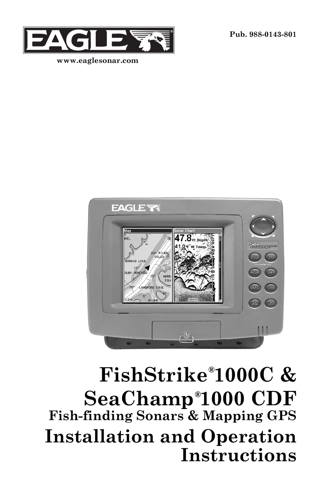
FishStrike1000C & SeaChamp1000 CDF
Models:
1000C
1
1
204
204
Download
204 pages
34.09 Kb
1
2
3
4
5
6
7
8
Install
Chart Speed
Alarms
Symbols with FishTrack depths
Warranty
Configure Nmea
Reset Options
Other Accessories
Speed/Temperature Sensors
How to
Page 1
Image 1
Pub.
988-0143-801
www.eaglesonar.com
FishStrike
®
1000C & SeaChamp
®
1000 CDF
Fish-finding
Sonars & Mapping GPS
Installation and Operation Instructions
Page 1
Page 2
Page 1
Image 1
Page 1
Page 2
Contents
FishStrike1000C & SeaChamp1000 CDF
Eagle Electronics Box Catoosa, OK USA
Copyright 2005 LEI-Eagle All rights reserved
Table of Contents
ASP Advanced Signal Processing
Iii
132
Tidal Current Information 150 Tide Information 152
Page
Section Read Me First
Page
General
GPS
How Your Sonar Works
How Your GPS Works
Introduction to GPS and Waas
Page
Page
How to use this manual typographical conventions
Page
Page
Preparations
Transducer Installation
Single-frequency transom installations
Deadrise less than Strakes Pad
Good location Poor location Location Poor angle
Page
Dot
Ratchet
Bolt Lock washer Nut Flat washer
Transom
Bottom Hull Flat-bottom hull Deep-vee hull
TMB-S bracket Internal tooth washer Bolt Nut Flat washer
Transducer Orientation and Fish Arches
Epoxy the transducer to a solid portion of the hull
Transducer location High speed Trolling speed
Page
Epoxy transducer to hull
Speed/Temperature Sensors
GPS
Optional Speed Sensor Installation
Good location
Nmea 0183 Cable Connections
GPS Antenna/Receiver Module Installation
Power Connections
Page
Mounting the Unit Bracket or In-Dash
Cable hole Screw mounting hole Front
In-dash mounting template for this unit, showing dimensions
MMC or SD Memory Card Installation
Other Accessories
Page
Keyboard
Section Basic Sonar Operation
Power/lights on and off
Main Menu
Pages
Navigation Page left navigation with sonar right
Sonar Page Display
Page
Sonar Page showing full sonar chart mode
FishStrike 1000C and SeaChamp 1000CDF Sonar Quick Reference
Sonar Operations
Page
Important Tip
Page
Page
Section Sonar Options & Other Features
Alarms
To turn off the alarm, press MENUMENU↓ to ALARMSENT↓ to
Calibrate Speed
Chart Speed
ColorLine
Depth Cursor
Cursor line Depth box
Depth Range Automatic
FasTrack
Depth Range Manual
Fish I.D. Fish Symbols & Depths
FishTrack
Symbols with FishTrack depths
HyperScroll
Log Sonar Chart Data
Overlay Data
Noise Rejection
Entent
To change displayed data font size
Overylay Data Style
Ping Speed & HyperScroll
Reset Options
Set Keel Offset
Reset Water Distance
Sensitivity & Auto Sensitivity
Page
Sonar Page & Sonar Chart Display Options
Sonar Chart Mode
Pages Menu, showing sonar chart display options
Page
Customize Page Displays
Data Viewer with the Sonar Data category expanded
Sonar Simulator
Onentexit
Surface Clarity
Stop Chart
Press ↓ or ↑ to select clarity levelEXITEXITEXIT
Transparency
Zoom & Zoom Bar
Zoom Pan
Page
Section
Page
Noise
Page
Basic GPS Operations
Power/lights on and off
Main Menu left with Browse MMC Files selected right
Pages Menu, showing some Map display options
Satellite Status
Navigation
Page
100
101
102
103
104
GPS Quick Reference
Moving Around the Map Zoom & Cursor Arrow Keys
Find Your Current Position
105
Searching
Selecting Any Map Item with the Cursor
106
107
108
Set a Waypoint
109
110
Navigate To a Waypoint
Navigate Back to MOB Waypoint
Set Man Overboard MOB Waypoint
111
112
Navigate to Cursor Position on Map
113
Creating and Saving a Trail
Navigate to a Point of Interest
114
115
Navigating Trails
Displaying a Saved Trail
116
117
118
119
Transfer Custom Maps and GPS Data Files
120
121
Cancel Navigation
122
Find Distance from Point to Point
Find Distance from Current Position
Icons
123
124
125
Routes
126
127
128
Delete a Route
129
130
Trails
131
Waypoints
Utilities
132
133
134
135
Section System & GPS Setup Options
Check MMC Files and Storage Space
Auto Satellite Search
136
Configure Nmea
Communications Port Configuration
137
138
Coordinate System Selection
139
Map Fix
140
141
142
GPS Simulator
Initialize GPS
Hide GPS Features
143
Map Data
Map Auto Zoom
144
145
146
Map Datum Selection
Map Orientation
Map Detail Category Selection
147
148
Navionics Charts
Entexitexit
149
150
151
152
Cursor line Pop-up name box Tide Station icon
153
154
155
156
157
158
159
160
Pop-up Help
161
Screen Contrast and Brightness
162
Set Language
163
Set Local Time
Software Version Information
Show Waas Alarm
164
Track Smoothing
Sounds and Alarm Sound Styles
165
166
Trail Options
167
168
169
Units of Measure
170
171
Find Addresses
172
173
Find Interstate Highway Exits
Find Any Item Selected by Map Cursor
174
175
176
177
Find Map Places or Points of Interest POI
178
Find Streets or Intersections
179
180
181
182
Find Waypoints
183
184
185
Supplemental Material Datums Used by This Unit
Grand Cayman, Jamaica
Great Britain
Wake Island Astro
FCC Compliance
186
Eagle Databases License Agreement
187
Databases Limited Warranty
188
Eagle Electronics Full ONE-YEAR Warranty
189
How to Obtain Service…
190
Accessory Ordering Information for all countries
Visit our web site
Top
Page
Image
Contents