FishElite502c iGPS & SeaCharter502cDF iGPS
Copyright 2005 LEI-Eagle All rights reserved
Table of Contents
Sonar Options & Features
Basic Sonar Quick Reference
Advanced GPS Operations 117
Sonar Troubleshooting Basic GPS Operations
Basic GPS Quick Reference
System & GPS Setup Options 131
Searching 161
Supplemental Material 175
Page
Read Me First
How this manual can get you out on the road, fast
Page
Back-up memory
SeaCharter 502cDF iGPS 4,000 watts
General
Sonar
Position updates
Depth capability SeaCharter 502cDF iGPS 1,500 feet
Audible alarms
Sonar Sounding
Position points
Graphic symbols for Waypoints or event
How Eagle Sonar Works
How GPS Works
Introduction to GPS and Waas
Page
Page
Emulator
Free Training Aids Available
Sonar Viewer
Arrow Keys
How to use this manual typographical conventions
Menu Commands
Keyboard
Page
Transducer Installation
Preparations
Selecting a Transducer Location
Pad Deadrise less than Strakes
Transom
How low should you go?
Shoot-Thru-Hull vs. Transom Mounting
Transducer centerline Hull bottom
Transom Transducer Assembly and Mounting
Assembling the bracket
Transducer bracket RatchetRatchet
Dot
Alignment letters Positions Transducer
Bolt
Aligning the transducer on the transom
Ratchets
Nut
Metal Nut Washer Rubber
Assembling the transducer
Drilling mounting holes
Washers
Attaching transducer to transom
Bottom Hull Flat-bottom hull Deep-vee hull
Trolling Motor Bracket Installation single-frequency only
Internal tooth washer TMB-S bracket Bolt Nut Flat washer
Transducer aimed
Transducer Orientation and Fish Arches
Partial fish arches
Too far back
Hulls With Flotation Materials
Testing Determines Best Location
Shoot-Thru-Hull Preparation
Second bottom True bottom Manual range setting
Transducer location High speed Trolling speed
Shoot-Thru-Hull Installation
Epoxy transducer to hull
Speed/Temperature Sensors
Socket
Optional Speed Sensor Installation
Accessory Sonar unit rear view
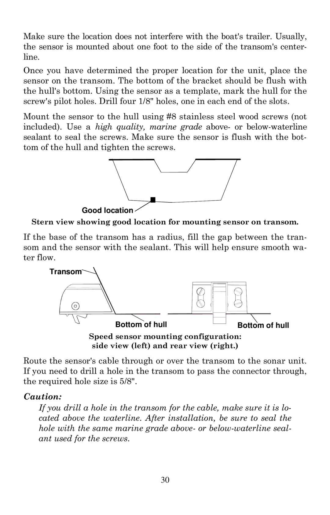
Good location
Transom Bottom of hull
Power Connections
Nmea Cable Connections
Nmea Wiring
GPS Internal Antenna
Mounting the Unit Bracket or Portable
Orange Receive
Bracket Installation
Front
Portable Installation
173.9 77.1 27.6 137.9 Millimeter 56.9 Inch
MMC or SD Card Memory Card Installation
Cell battery
To add an MMC or SD Card
Other Accessories
To remove an MMC
Thumb ScrewInsert card face up, this way
MapCreate 6 CD-ROM left. MMC card reader for USB ports right
Basic Sonar Operation
Keyboard
Power/lights on and off
Main Menu
Main Menu
Pages
Satellite Status
Background map vs. MapCreate map content
Tip
Marker School POI Restaurant
Minor Interstate Major Street Cursor line Streets
Pop-up
Zoom Range Position, distance Bearing data
Resize Window command
Page
Basic GPS Quick Reference
Find Your Current Position
Moving Around the Map Zoom & Cursor Arrow Keys
Cursor line Pop-up name box Selected wreck
Selecting Any Map Item With the Cursor
Searching
101
Page
Create Waypoint at Current Position
Set a Waypoint
To create and save a Waypoint
Create Waypoint by Entering a Position
Step
Create Waypoint on Map
Navigate To a Waypoint
Set Man Overboard MOB Waypoint
Navigate Back to MOB Waypoint
Navigate to Cursor Position on Map
Navigate to a Point of Interest
Creating and Saving a Trail
Visible Active Symbol
To Save a Trail
Displaying a Saved Trail
To turn off trail display
Navigate a Trail
Navigating Trails
Visual Trailing
Page
Red course
Navigate a Back Trail
Present position arrow North Magenta trail line Trail point
GPS Data files
Transfer Custom Maps and GPS Data Files
Custom Maps
115
Cancel Navigation
Icons
Find Distance From Current Position To Another Location
Find Distance From Point to Point
Delete an Icon
Create Icon on Map
Create Icon at Current Position
Routes
Navigate to an Icon
Routes Created in the Unit
Create and Save a Route
PC-created Routes
121
Delete a Route
Edit a Route Name
Edit Route Waypoints
Navigate a Route in Reverse
MENUMENU↓ to Cancel NAVIGATIONENT← to Yesent
Navigate a Route
Trail
Trails
Delete a Trail
MENUMENU↓ to
Edit a Trail Pattern
Edit a Trail Name
Edit a Trail Color
Utilities
Waypoints
Waypoint Name
To delete a waypoint from the map
Edit a Waypoint
Waypoint Position
Set a Waypoint by Projecting a Position
Selecting a Waypoint
Set a Waypoint by Average Position
Page
System & GPS Setup Options
To change alarm settings
Communications Port Configuration
Check MMC Files and Storage Space
Configure Nmea
Press MENUMENU↓ to GPS Setupent
Coordinate System Selection
To setup Loran TD
Map Fix
To configure a map fix
Data Viewer with GPS and Navigation categories opened
GPS Simulator
To get to the GPS Simulator
Initialize GPS
Hide GPS Features
Press MENUMENU↓ to GPS Setupentent
Simulating Trail or Route Navigation
Map Auto Zoom
Map Data
Map Boundaries
Show Map Data
Pop-up Map Information
Fill Water With White
Map Datum Selection
Map Detail Category Selection

 location