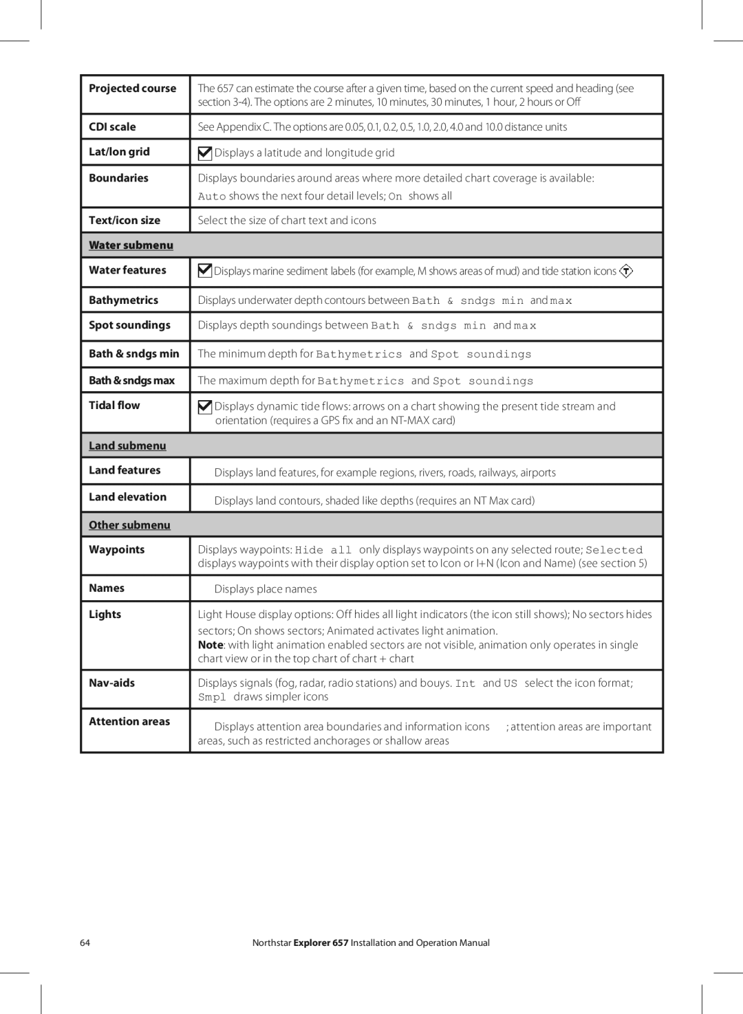
Projected course | The 657 can estimate the course after a given time, based on the current speed and heading (see |
| section |
|
|
CDI scale | See Appendix C. The options are 0.05, 0.1, 0.2, 0.5, 1.0, 2.0, 4.0 and 10.0 distance units |
|
|
Lat/lon grid | Displays a latitude and longitude grid |
|
|
Boundaries | Displays boundaries around areas where more detailed chart coverage is available: |
| Auto shows the next four detail levels; On shows all |
Text/icon size | Select the size of chart text and icons |
|
|
Water submenu |
|
|
|
Water features | Displays marine sediment labels (for example, M shows areas of mud) and tide station icons |
|
|
Bathymetrics | Displays underwater depth contours between Bath & sndgs min and max |
Spot soundings | Displays depth soundings between Bath & sndgs min and max |
|
|
Bath & sndgs min | The minimum depth for Bathymetrics and Spot soundings |
Bath & sndgs max | The maximum depth for Bathymetrics and Spot soundings |
Tidal flow | Displays dynamic tide flows: arrows on a chart showing the present tide stream and |
| orientation (requires a GPS fix and an |
|
|
Land submenu |
|
|
|
Land features | Displays land features, for example regions, rivers, roads, railways, airports |
|
|
Land elevation | Displays land contours, shaded like depths (requires an NT Max card) |
| |
|
|
Other submenu |
|
|
|
Waypoints | Displays waypoints: Hide all only displays waypoints on any selected route; Selected |
| displays waypoints with their display option set to Icon or I+N (Icon and Name) (see section 5) |
Names | Displays place names |
|
|
Lights | Light House display options: Off hides all light indicators (the icon still shows); No sectors hides |
| sectors; On shows sectors; Animated activates light animation. |
| Note: with light animation enabled sectors are not visible, animation only operates in single |
| chart view or in the top chart of chart + chart |
|
|
| Displays signals (fog, radar, radio stations) and bouys. Int and US select the icon format; |
| Smpl draws simpler icons |
Attention areas | Displays attention area boundaries and information icons ; attention areas are important |
| |
| areas, such as restricted anchorages or shallow areas |
|
|
64 | Northstar Explorer 657 Installation and Operation Manual |