Manuals
/
Standard Horizon
/
Marine Equipment
/
Marine GPS System
Standard Horizon
CP175C, CP1000C, CP155C
owner manual
GPS chartplotters
Models:
CP175C
CP155C
CP1000C
1
17
82
82
Download
82 pages
28.09 Kb
14
15
16
17
18
19
20
21
Troubleshooting
Specifications
Mounting the GPS Chartplotter
Alarms
Controls and Indicators
Resetting the Trip Log
Optional Accessories
Video Connector for CP1000C
Battery Connections
Adjusting the Time
Page 17
Image 17
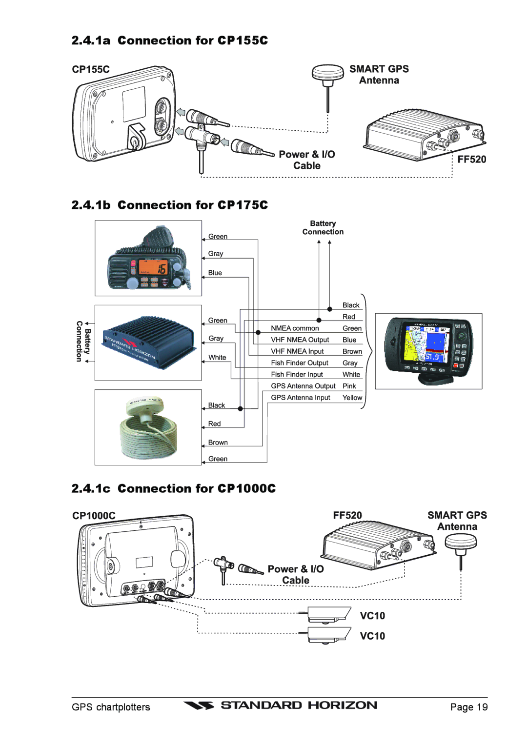
2.4.1a Connection for CP155C
2.4.1b Connection for CP175C
2.4.1c Connection for CP1000C
GPS chartplotters
Page 19
Page 16
Page 18
Page 17
Image 17
Page 16
Page 18
Contents
CP155C / CP175C / CP1000C
FCC Compliance Statement
Cleaning Procedure for the Chart Plotter Screen
Page
Table of Contents
Creating Marks
Using Find Services & More Function
Routes
Tracks
Trouble Shooting Technical Tests
Advanced Settings
Specifications
Appendix Terms Index
GPS chartplotters
General Information
Introduction
Packing List
0 CP155C Packing List
0a CP155C Optional Accessories
Optional Accessories
0b CP1000C Optional Accessories
1 CP175C Packing List
0b Color Video Camera
GPS chartplotters
Getting Started
Mounting the GPS Chartplotter
Bracket Mounting
Flush Mounting
Mounting the GPS Smart Antenna
Installing/removing chartplotter Flush
Connections
Flush Mounting
Smart GPS Cable
Video Connector for CP1000C
0b Connection Table for CP175C 12VDC Power and Nmea Cable
GPS chartplotters
Nmea Connections
Battery Connections
GPS Position on a VHF Radio
Other DSC VHF Manufactures
Outputting Nmea to a Personal Computer
Connecting Digital INSTRUMENTS/AUTOPILOT/RADAR
Optional Black BOX Fish Finder
VCR or DVD Input
Nmea Data
Video Input for CP1000C only 2.12.0 Video Camera Input
Quick Activation by soft keys
From the menu
Quick Activation by pressing Clear for 1 second
14 Inserting C-CARD
Optional C-MAP NT+ Cartography Inserting the C-CARD
Controls and Connections
Controls and Indicators
0a The alphanumeric keys on CP1000C
Power On, Off and ShuttlePoint operation
0b The soft keys on CP175C/CP1000C
Getting Started
Cursor Mode
Cursor Vs. Home Mode
Changing the Ships Icon
Home mode
Cursor and Menu selection speed
Selecting North Up or Course Up
Changing the backlight and contrast
Adjusting Time
Adjusting the Time
Coordinate System Menu
Selecting Loran TD or Other Coordinate System
Selecting Pages Using Soft Keys
Changing the Chart Color
Customizing the Soft Keys
Other Settings in General Setup Menu
Language
Other Available Searches
Using Find Services & More Function
Port Services
GPS chartplotters
Creating Marks
Creating a NEW Mark Using the Chart
Editing a Mark
Mark
Moving a Mark or Waypoint
Deleting a Mark or Waypoint
Creating a NEW Mark with the MARK/WAYPOINTS List
MARK/WAYPOINTS List
Goto Cursor
Goto Cursor
Press Menu and select User Points
Goto Mark
GPS chartplotters
Deleting a MOB Point
MAN Over Board MOB Function
GPS chartplotters
Routes
Creating a Route Using Waypoints
Making Additional Routes
Creating a Route Using Marks on the Chart
Inserting a Waypoint Into a Route
Other Settings in Route Menu
Goto a Route
By select Route
GPS chartplotters
Tracking
Tracks
Saving and starting a new Track
Other Settings in Track Menu
Using the Trip LOG
Using the Trip Log
Resetting the Trip Log
GPS chartplotters
Formatting the User C-CARD
User C-CARD
User C-CARD Menu
Loading a file
Transferring files to the optional User C-CARD
Deleting a file from the User C-CARD
Changing the User C-CARD
Selection by Soft KEY
Pages
Selection by Menu
Window Selections
Chart
Turning Off Information on Icon Points
Additional Functions on Chart
Setting up the Chart Page using the Map Setup Selection
Marine Settings Menu
Advanced Chart SetUp
Land Settings Menu
Depth Settings Menu
Chart Settings Menu
Customizing the Data Windows
Navigation
Customizing Chart Settings
Navigation Data page with Compass Rose
Highway
GPS Status
Celestial
Changing date
Changing to and from Daylight Savings time
Changing the Nmea page Windows
Nmea Display
Interfacing
Nmea DEPTH, Wind SPEED, Temp and SOG Trend Pages
VHF Digital Selective Calling
Position Request
DSC Distress Call
GPS chartplotters
Navigate
Advanced Settings
INPUT/OUTPUT Nmea
Coordinate System Selections are
Compass
Arrival Alarm
Alarms
GPS chartplotters
Trouble Shooting
GPS chartplotters
Technical Tests
RAM Menu reset
System Test
DIM Menu
Modem test
Cartridges
Serial Ports
MAP NT+ C-CARD
Specifications
14.0a CP155C Specifications
0b CP175C chartplotter Dimensions mm/inch
14.0b CP175C Specifications
0c CP1000C chartplotter Dimensions mm/inch
14.0c CP1000C Specifications
Smart Waas Receiver Specifications
Appendix Terms
Units
ALT
Index
26, 37
Code XSegSH11c/S3egSH5c/S3egSH7c 321c784/321c736/322c844
A N D a R D H O R I Z O N L I M I T E D W a R R a N T Y
Top
Page
Image
Contents