Release Date 12/14/00
REV C Sheet
ALL Revisions REV Description
Honeywell MK Xxii Egpws Installation Manual
Table of Contents
Honeywell MK VI MK Viii Egpws Installation Design Guide
Honeywell MK VI MK Viii Egpws Installation Design Guide
104
Section V Certification
158
143
149
160
Aircraft Application Data
Section General Information
Honeywell MK Xxii Egpws Installation Manual
Section I General Information
License Requirements
How To Use This Docu ment
Introduction
Applicability
Reference Documents
Description of Equipm ent
GPS Antenna
MK Xxii Egpws Comp uter
MK Xxii Egpws Conf iguration Module
OAT Sensor
Smart Cable Pcmcia Interface
MK Xxii Egpws Smart Cable
Technical Characteris tics
Configuration Module
Units Supplied
MK Xxii Egpws
Honeywell MK Xxii Egpws Installation Manual
2 RS-232 Cable
Installation and Acces sories Kits
New Egpws installation with Internal GPS
Smart Cable
Terrain Database Card s
Flight History Card
GPS Antenna & cable
Circuit Breaker
Annunciators & Switc h/Annunciators
Cockpit Speaker Opti onal
Insertion/Removal Too l P1, P2, P3
Tools Required Crimping Tool P1, P 2, P3
Contact Positioner P 1, P2, P3
Spare Contacts P1, P 2, P3
Honeywell MK Xxii Egpws Installation Manual
Section Installation
Honeywell MK Xxii Egpws Installation Manual
Section II Installation
Equipment Installation 2.3.1 General
Unpacking and Inspec ting the Equipment
MK Xxii Computer Loc ation
MK Xxii Computer Ins tallation
Configuration Module Location
Configuration Module Installation
Configuration Module Assembly
Required
Installation Assembly Sequence
1 MK Xxii Egpws Configuration Module
2 MK Xxii Egpws Configuration Module
3 MK Xxii Egpws Configuration Module
4 MK Xxii Egpws Configuration Module
5 MK Xxii Egpws Configuration Module
6 MK Xxii Egpws Configuration Module
7 MK Xxii Egpws Configuration Module
Cockpit Annunciators / Switches
GPS Antenna Installat ion
OAT Sensor Installatio n
GPS Antenna location
Description
Egpws cautionGPWS G/S Cancld
Location
Gpws warning red & Gpws alert amber
8 MK Xxii Egpws Annunciators/Switches Location
Terrain Inhibit
Inhibit Switch Functio ns and Selection
Low Altitude Mode
Audio Inhibit Timed
MK Xxii Egpws Outline
MK Xxii Egpws Mounting Tray
Honeywell P/N 405-0383-001
Honeywell MK Xxii Egpws Installation Manual
Section System Planning
Honeywell MK Xxii Egpws Installation Manual
Section III System Planning
Category 8 Radio Altitude Input Select
Category 14 Audio Output Level
System Wiring/ Electr ical Interfaces
Primary Power Input
Chassis Ground
Analog and Digital Inp uts
Discrete Inputs
Serial Outputs
Audio Output
Discrete Outputs
Aircraft / Mode Type
Configurable Interface s
Category 1 Aircraft / Mode Type Select
Instructions
Category 2 Air Data Input Select
Examples Analog altitude and 500 ohm OAT
Egpws MK
Digital Arinc 429 Cat ID 5, 1
Digital -ARINC 575 Cat ID
Arinc
Shadin 2000 Cat ID
Digital Arinc 429 Dual IOC Buses Cat . ID
Category 3 Position Input Select
Arinc 743 Format
Examples Arinc 429 BUS Cat ID 0,1,4,5
3.2 RS-232 Transmit-Receive, 9600 baud Cat ID
Dual Arinc 429 BUS Cat ID
Category 4 Altitude Callouts
Category 5 Audio Menu Select
Category 6 Terrain Display Select
TAD Selection
Terrain Display Configuration Group
Type of sweep used for terrain data fan, standard, etc
6-1 Single Tube Wx/Terrain Display
Display Input Control Group
Output 429 Bus Group
Example
Egpws
TRA-45A
J101
Egpws Avidyne FSD
Honeywell Radar Indicator
Honeywell WRX R/T
Avtech DSU
Arinc 429 Range #1 Arinc 429 Range #2 Kcpb Video #1 Out
Category 7 Options Select Group #1
Steep Approach Not Available in the Mk
7.3 TA&D Alternate Pop-up
Peaks Mode
Obstacle Awareness
Bank Angle Callout Enabling
WOW Reversal
GPS Altitude Reference
Category 8 Radio Altitude Input Select
Example Digital Radio Altitude Interface
DH Discrete Gnd Valid Radio Altimeter Indicator
Analog Radio Altitude Interface
Category 9 Navigation Inputs Select
Example Analog Glideslope Interface cat ID 0,1,5
RNA-34A
Digital Glideslope/Localizer Interface
Dual Glideslope Receiver
Attitude Signals
Category 10 Attitude Input Select
Example Analog Roll Angle Synchro
Vertical Gyro
Digital Arinc 429 High Speed
Ahrs
Category 11 Heading Input Select
Magnetic Heading
Example Analog Heading Synchro CAT ID
Directional Gyro
Heading High Speed
Category 12 Windshear Input Select
Instruction
Category 13 Input / Output Discrete Type Select
Input/Output Discretes
Weight on Wheels WOW Discrete
Audio Inhibit Discrete
Landing Gear Discrete
Glideslope Cancel Discrete
Mode 6 Low Volume Discrete
Autopilot Engaged Discrete
Terrain Awareness Inhibit
Self Test Discrete
Glideslope Inhibit Discrete
Output Discretes
Low Altitude Mode Select Discrete
Timed Audio Inhibit Discrete
Lamp Format
Gpws Warning Discrete
Gpws Inop Discrete
TAD Inop Discrete
Gpws Alert Discrete
Low Altitude Mode Discrete
Terrain Display Select #1 & #2 Discrete
REV C Sheet
Category 14 Audio Output Level
Ohm
Category 15, Autorotation Threshold
Autorotation Threshold
107
108
Egpwc Initialization a nd Configuration
Harness Checkout and Power Check
Unit Installation
1 RS-232 Communicatio n with the MK Xxii Egpws
Egpwc Front Panel T est Connector
WinVIEWS
Configuration Module Programming
WinVIEWS Operation
112
CUW and CMR Comm ands
CFG CUW 0/15 128 3 2 134 128 3 29 1 0 2 0 0 129 0
Configuration Module Reprogramming
CATspacecategory #spaceID#spaceT or FEnter
Regional Terrain Data base Loading 4.6.1 Effectivity
Approval
Material Cost and Av ailability
Accomplishment Instr uctions
Verification of the Ter rain Database Version
END of Test
120
Section Certification
Honeywell MK Xxii Egpws Installation Manual
Section V Certification
FAA Requirements
Certification Procedur e Equipment Compatibi lity
Equipment Location
Ground Test
Pilots Guide
Failure Modes, Effects , and Safety Analysis
Flight Test
Existing STC’s
Honeywell MK Xxii Egpws Installation Manual
Appendix a Customer Worksheet
Honeywell MK Xxii Egpws Installation Manual
MK Xxii Egpws
Cockpit Displays
GPS
Discrete Inputs
Parameter
Generic Model Information
System
REV C Sheet
REV C Sheet
REV C Sheet
REV C Sheet
REV C Sheet
Appendix B Sample Wiring Diagrams
DWG no 060-4314-225 Revc Sheet
Honeywell MK Xxii Egpws Installation Manual
Honeywell MK Xxii Egpws Installation Manual
Appendix C
Honeywell MK Xxii Egpws Installation Manual
RS-232 Communication with the Egpws
Baud, No Parity, 8 bits, and 1 stop bit
REV C Sheet
REV C Sheet
Honeywell MK Xxii Installation Manual
Appendix D Vendor Drawings
Honeywell MK Xxii Egpws Installation Manual
Vendor Contact Information
AMP
For orders and AOG requirements, contact
D1-1 Edmo
GPS RF Cable Sets
D1-2 Emteq
Per 100 ft
Inches Bend Radius Minimum
1 Connectors for Tflx cable series GPS
1 Connectors for Pflx cable series GPS
Tool Frame and Die Part Numbers
Installation Considerations
Aerospace Optics Inc
D1-3 Aerospace Optics
Mail switches@vivisun.com
StacoSwitch
Honeywell MK Xxii Egpws Installation Manual
Appendix E Interface Description Document
Honeywell MK Xxii Egpws Installation Manual
Connector Interface
Introduction Part Number
Purpose
System Overview
Electrical Interface Introduction
Signal Interfaces
Primary Power Input
Chassis Ground
LOW Level Glideslope
DC Analog Inputs
Radio Altitude
Localizer Deviation or LOW Level Glideslope Validity
2.4
Outside AIR Temperature
Configuration Defined DC Inputs
Barometric Altitude
Synchro Roll Attitude
AC Analog Inputs
2.7.1
2.7.2
Configuration Defined Synchro Inputs
Signal Timing Reference Inputs
2.9
Arinc 429/575 Digital Serial BUS Inputs
2.9.1 RS-232 / RS-422 Digital Serial BUS Inputs
GPS RS-232 Digital Serial BUS Serial Port
GPS RS-422 Digital Serial BUS Serial Port
AIR Data RS-422 Digital Serial BUS Serial Port
+28 VDC Discrete Characteristics
AIR Data RS-232 Digital Serial BUS Serial Port
SCI Range RS-422 Digital Serial BUS Serial Port
Configuration Module Interface
Ground Discrete Characteristics
GPS Antenna Input
OAT Voltage Reference Output
Monitor Output Characteristics
Discrete Output Characteristics
Lamp Driver Outputs
Arinc Digital Serial Output Busses
High Level Speaker Audio Output
LOW Level Interphone Audio Output
Arinc 429 Output BUS
2.18.1 RS-232 Maintenance Port Serial Port
Arinc 453 Output BUS
Front Panel Test Interface
Front Panel Status Indicators
Pcmcia / Smartcable Port
GSE Present Discrete Input
Configuration Types
Configuration Selection
Aircraft Application Data
Signal Selection
Table E 3 Category ID Selection Procedure
Instruction
Configuration Selection Tables
Category 1, Aircraft / Mode Type Select
Torque Type Table E
Effectivity App Cfg
Fault Designation Engine 1 BUS Bus Type Basic
Fault Designation Engine 2 BUS Bus Type Basic
Engine Torque Data Selection
Fault Designation Engine 1 BUS Bus Type RS-422 9600 baud
Fault Designation Engine 2 BUS Bus Type RS-422 9600 baud
Torque Data Select 10 Bell Summary Data
Torque Data Select 8 AS365 Dauphin N3
Torque Data Select 9 Bell
Torque Data Select 11 Bell 212/412 Summary Data
Torque Data Select 16 Common DC Torque
Fault Designation Engine 1 BUS
Torque Data Select 14 Coast Guard HH-65 Summary Data
Connection Summary Data
Category 2, AIR Data Input Select
Table E Description
Table E 3.1.2 AIR Data Input Select for Egpws Mkxxii
Configuration Data
Fault Designation AIR Data BUS Bus Type Basic
Type Summary Data
Table E 3.1.2-3 AIR Data Input Select #3 Summary Data
Table E 3.1.2-4 AIR Data Input Select #4 Summary Data
Table E 3.1.2-5 AIR Data Input Select #5
Connect to Channel
Channel Connect to
Channel 429RX2
Table E 3.1.2-6 AIR Data Input Select #6
Table E 3.1.2-10 AIR Data Input Select #10
Table E 3.1.2-11 AIR Data Input Select #11 Summary Data
3.3
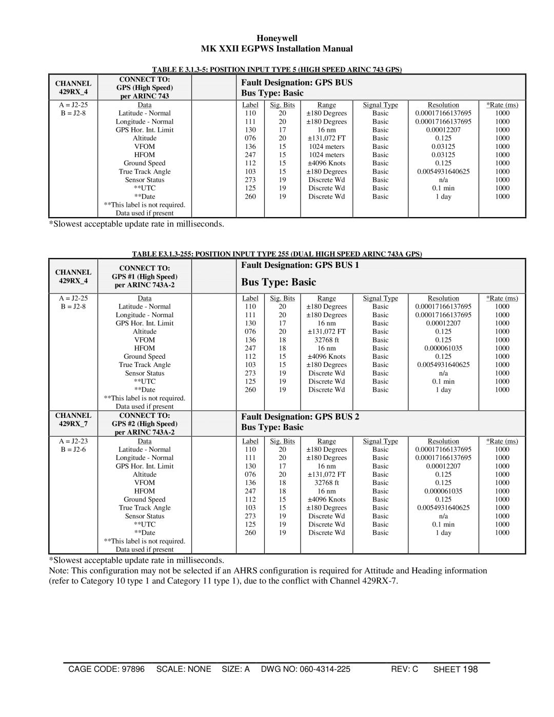
Category 3, Position Input Select
Position Input Type TableE Description
Fault Designation GPS BUS Bus Type Basic
UTC
Fault Designation Internal GPS Bus Type Basic
Internal
Fault Designation GPS BUS
Bus Type Basic
Category 4, Altitude Callouts
App Cfg
Table E 3.1.4 Altitude Callouts for Egpws Mkxxii
Honeywell MK Xxii Egpws Installation Manual
Table E 3.1.5 Audio Menu Type
Category 5, Audio Menu Select
Effectivity App Cfg 006
Table E 3.1.5-128 Audio Menu Type 128 Basic Helicopter
Section Overview
IDand TCF Disable Application Notes
Category 6, Terrain Display Select
Defined By
Honeywell MK Xxii Egpws Installation Manual
Table E KC Picture Bus
Table Table E 3.1.6-1 No Display TAD and TCF Enabled
Table Table E 3.1.6-2 TA&D / TCF Disabled
Channel
Table Table E 3.1.6-3 Collins ProLine II
Fault Designation Display BUS Bus Type Basic
Display Configuration Group 6 Collins PRO-LINE II
Integration note
Display Configuration Group 1 Bendix RDR 4A/B PPI with MOD
Table Table E 3.1.6-4 Bendix PPI-4A/4B
Display Configuration Group 2 Collins Proline II
Table E Collins ProLine II
Display Configuration Group 3 Collins Proline II, 5X4
Table E Collins ProLine II 5x4,5x5
Display Configuration Group 7 NON-INTEGRATED Efis 40/50
Table E Non-Integrated Efis 40/50 Honeywell/Bendix
Peaks Always Enabled
Display Configuration Group 8 Integrated Efis 40/50
Table E 3.1.6-10 Integrated Efis 40/50 Honeywell/Bendix
Honeywell MK Xxii Egpws Installation Manual
Table E 3.1.6-12 Collins WXI-701/711, without Auto Range
Terrain Display BUS #2
Integration note Pins
Terrain Display BUS #1 453TX1
Reference Name
Table E 3.1.6-14 Bendix PPI-4A/4B without Auto Range
Terrain Display BUS #2 453TX2
6.2-3 Display Input Control Group
Reference Name PIN Function
6.3-0OUTPUT 429 BUS Group Traceability
Table E 3.1.6-16 Bendix IN182A/IN812A Radar display RDR
Reference section
Pins Comments
Output 429 Bus Group
Category 7, Options Select Group #1
Table E Bendix IN842A/IN862A Radar display RDR
Function Value
TA&D Alternate Pop Up False TA&D Alternate Pop Up True
Display Input Control Group
Display Input Control Group
Honeywell
Fault Designation IOC BUS
Table E3.1.6-236 Display Configuration Collins ProLine IV
Honeywell
Channel 429RX8
Table E 3.1.6-246 Non-Integrated Efis 10 Bendix/Honeywell
Connect to DC811 #1 Display Input Control Group
Channel 422RX2
Connect to DC811 #2
Honeywell MK Xxii Egpws Installation Manual
SCI Bus RS-422 12K baud
Category 7, Options 1 Select
Altitude Reference6 Effectivity App Cfg
Table E 317 Options Select Group #1
True False WGS-84
Category 8, Radio Altitude Input Select
Radio Altitude Type Table E Description
Description Value
PIN Function Connection
PIN Type Channel Designation Reference
Table E 3.1.8-5 Radio Altitude Input Select Type 5 ALT
Reference Summary Data
Table E 3.1.9-0 Navigation Inputs Select Summary Data
Category 9, Navigation Input Select
Table E 3.1.9 Navigation Input Select for Egpws Mkxxii
Connection PIN Type
Fault Designation ILS BUS Bus T ype Basic
Fault Designation ILS BUS
Table E 3.1.10 Attitude Input Select for Egpws MK
Category 10, Attitude Input Select
Attitude Input Select
Table E 3.1.10-0 Attitude Input Select Type
Fault Designation Ahrs BUS
Table E 3.1.10-4 Attitude Input Select Type
Table E 3.1.10-128 Attitude Input Select Type Connect to
Heading Input Select Table E Description
Fault Designation Ahrs BUS Bus Type Basic
Category 11, Heading Input Select
Table E 3.1.11 Heading Input Select for Egpws MK
Effectivity App Cfg 003
Category 12, Windshear Input Select
No Windshear
Table E 3.1.12 Windshear Input Select
Category 13, Input / Output Discrete Type Select
Input/Output Discrete Type Table E
Configuration Data Possible States
State
Table E 3.1.13-128 INPUT/OUTPUT Discrete Type
Table E 3.1.13-129 INPUT/OUTPUT Discrete Type
Volume Select
Category 14, Audio Output Level
Table E 3.1.14 Audio Output Level
Category 15, Autorotation Threshold
Autorotation Threshold Torque
Table E 3.1.15 Autorotation Threshold for Egpws MK
SYN1X SYN1Z SYN2Z
Connector Pin
Refer to Category 13 where multiple uses are possible
Honeywell MK Xxii Egpws Installation Manual
Figure E 4.1, Connector Pin References J1, J2, J3
AcronymInterpretation
Definitions
Acronym Interpretation
Pcmcia