MC35
Page
User Guide for Windows Mobile
MC35
Motorola, Inc One Motorola Plaza Holtsville, New York
Copyright
Welcome
Welcome
Welcome
Contents
Using Phone 111
Using the Windows Mobile Programs
User Support 219
Using GPS Navigation 147
Using MC35 Companion Programs 153
Customizing your MC35 203
Page
Preparing to use your MC35
Package contents
Preparing to use your MC35
Charging the MC35
System installation requirements
Installing Microsoft ActiveSync
Starting the MC35
Creating an ActiveSync partnership
Help About Microsoft ActiveSync
Preparing to use your MC35
Preparing to use your MC35
Audio
Features summary
Performance
Display
Battery pack
Hardware connectivity
Design and ergonomics
Accessories
Hardware tour
Hardware tour
Component Description
SD/MMC
Hardware interface
Using the touch screen backlight key
Using the stylus
Using the SD/MMC expansion slot
Hardware interface
Soft buttons and keypad
Hardware interface
Secondary keypad input mode
Today screen
Command interface
Command interface
Tap Settings
Icon Description
Start menu
Navigation bar
Status icons
Command interface
Command bar
Pop-up menus
Notifications
Word Completion
Using the MC35 keypad
Using the Input Selector
Using the MC35 keypad
Keyboard
Using the Input Selector
Tap the Input Selector arrow, then select Letter Recognizer
Block Recognizer
Letter Recognizer
Tap the Input Selector arrow, then select Block Recognizer
Transcriber
Tap Menu Draw
Writing on the screen
Star Key
Writing on the screen
Tap Menu Tools Recognize
Tips for getting good recognition
Drawing on the screen
Drawing on the screen
Conversion reminders
Tap Menu View Recording Toolbar
Recording a message
Recording a message
Tap Programs Notes
Using My Text
Using My Text
Using ActiveSync
Using ActiveSync
Synchronizing information with your computer
Open ActiveSync Click File Connection Settings
Tap Programs ActiveSync Tap Menu Connections
Infrared Port IR
Tap Programs ActiveSync Tap Menu Connect via IR
Tap Settings Connections tab Bluetooth
Tap Programs ActiveSync Tap Menu Connect via Bluetooth
Synchronizing with a server
Tap Programs ActiveSync
Tap Programs ActiveSync Tap Menu Schedule
Tap Menu Add Server Source
Tap Advanced
Tap Finish
Tap Programs ActiveSync Tap Menu Options
Using ActiveSync to copy files
Synchronization options
Remote synchronization schedule
ActiveSync errors
Synchronization type and volume
Click Tools Options
Using wireless communication
Using wireless communication
Opening programs
Opening programs
Icon Program Usage
Program list
Opening programs
Using Search
Using File Explorer
Using Search
Using File Explorer
Using File Explorer
Wireless communication features
Wireless communication features
Beam function
Infrared connection
Exchanging files using IR connection
Activating the Bluetooth function
Bluetooth connection
Creating a Bluetooth partnership
Wireless communication features
Exchanging files using Bluetooth
Gprs connection
Configuring your Gprs connection
Tap Connect Gprs
WiFi connection
Connecting to the Gprs network
Activating a WiFi connection
Select Enable Wi-Fi Card
Setting up a wireless network connection
Wireless communication features
To connect to a wireless network
Tap Finish
Activating wireless features
Managing wireless connections
Using Wireless Manager
Managing wireless connections
Tap Phone Done
Tap WiFi Done
Configuring the multiple wireless settings
Select Phone Settings
Tap Menu Disconnect Cellular Data
Connecting to the Internet
Getting connected
Getting connected
Flight Mode
Connecting to your office network
Tap Add New URL
Viewing intranet URLs
Tap Messaging Tap Menu Tools New Account
Setting an e-mail server connection
Tap Calendar
Microsoft Outlook Mobile programs
Calendar
Microsoft Outlook Mobile programs
Tap Menu New Appointment
Scheduling an appointment
Viewing an appointment
Finding an appointment
Synchronizing calendar items
Using the Calendar summary screen
Beaming an appointment
Creating a meeting request
Tap Contacts
Contacts
Calling a contact
Using the Contacts summary screen
Sending a message to a contact
Tap Send Contact Beam
Beaming a contact card
Synchronizing contacts
Tap Send E-mail or Send Text Message
Tap Menu New Task
Tasks
Managing tasks
Tap Programs Tasks
Tap Beam Task
Using the Tasks summary screen
Beaming a task item
Synchronizing tasks
Tap Programs Notes . Notes opens to the note list
Managing notes
Tap Menu Tools Beam
Sending a note
Synchronizing notes
Tap Beam File
Tap Menu Send /Receive
Using the message list
Messaging
Tap Messaging
Creating an e-mail/text message
Creating a message signature
Tap Menu Tools Options
Managing messages and folders
Downloading messages
Synchronizing Outlook e-mail messages
Synchronizing POP3/IMAP4 e-mail messages
Microsoft Office Mobile programs
Word Mobile
Microsoft Office Mobile programs
Creating a Word Mobile document
Using the Word Mobile document list
Tap Menu Send
Tips for working in Word Mobile
Sending a Word Mobile document
Tap Menu Beam File
Excel Mobile
Synchronizing Word documents
Help
Tap View Full Screen
Using the Excel Mobile workbook list
Creating an Excel Mobile workbook
Tips for working in Excel Mobile
Synchronizing Excel workbooks
PowerPoint Mobile
Using PowerPoint Mobile
Sending an Excel Mobile workbook
Microsoft Office Mobile programs
Show Options
Setting the slide show playback options
Sending a PowerPoint file
Go to Slide
Tap Windows Media
Windows Media Player
Copying files to your device
Windows Media Player
Tap Windows Media Tap Menu Update Library
Library
Playlist
Tap Menu Queue Up Tap Menu Now Playing
Windows Media Player
Tap Menu Properties
Viewing track properties
Tap Menu Open URL
File Playback
Playing a file stored in your device or in a storage card
Playing a streaming media file
Tap Menu Shuffle
Using skins to change the Player look
Customizing the Player
Playback controls
On the Playback screen, tap Menu Options Playback tab
Changing your audio and video settings
On the Playback screen, tap Menu Options Network tab
Changing your network settings
On the Playback screen, tap Menu Options Buttons tab
Setting hardware playback controls
Changing the startup screen
On the Playback screen, tap Menu Options Library tab
Licenses and Protected files
Internet Explorer Mobile
Internet Explorer Mobile
Browsing the Internet
Tap Menu Favorites
Viewing the History list
Mobile favorites
Tap Menu History
Mobile Favorites folder
Favorite Links
Mobile Favorites
Pocket MSN
Pocket MSN
Tap Programs Pocket MSN
Tap Sign
Tap Today Tap Tap here to sign in to Pocket MSN
MSN Hotmail
Tap Programs Pocket MSN Tap MSN Hotmail
Menu Send/Receive
Tap Programs Pocket MSN Tap Options Hotmail
Tap Programs Pocket MSN Tap MSN Messenger
Setting up an account
MSN Messenger
Requirements to use MSN Messenger
Tap MSN Mobile Home Tap Sign Tap Get a new Windows live ID
Pocket MSN
Pocket MSN
Tap Menu Sign Out
Tips when chatting with contacts
110
Phone setup
Phone setup
Installing the SIM card
Using Phone
Phone setup
Tap Phone
Entering your PIN
IconDescription
Dialer screen
Dialer buttons
Dialer screen
Phone operation
Phone operation
Phone status icons
Turning the phone function on and off
Tap to launch Wireless Manager
Erasing number input
Rejecting a call
Adjusting the phone volume
Using the speakerphone
Answering a call
Making phone calls
Muting a call
Tap Contacts . Contacts opens to the contact list
Tap Call History
Tap Speed Dial
Tap Settings
Phone features
Phone features
Making an emergency call
Call hold
Call notification and identification
Conference call
Call notes
On the Notes screen, tap Menu View Recording Toolbar
Tap Call History
Text messaging service
128
Tap Menu Send Text Message
To retrieve your voice mails
Voice mail
Sharing contacts in Microsoft Contacts
Contacts integration
Sharing contacts in call history
Sharing contacts in SIM Contacts
Call History
Category Description
Call history limit
Call details
Phone profiles
Phone profiles
Tap Menu Active
Tap Save OK Tap OK Yes
Tap New Yes
Tap Menu Edit
Tap Advance
Phone preferences
Phone preferences
Tap Menu Delete Tap Yes OK
Phone tab
Configuring your PIN
Call barring
Services tab
Call forwarding
Caller ID
Call waiting
On the services list, tap Voice Mail and Text Messages
Voice mail and text messages
Fixed dialing
Network tab
Move Down buttons
Band tab
Unpacking the MC35 vehicle mount kit
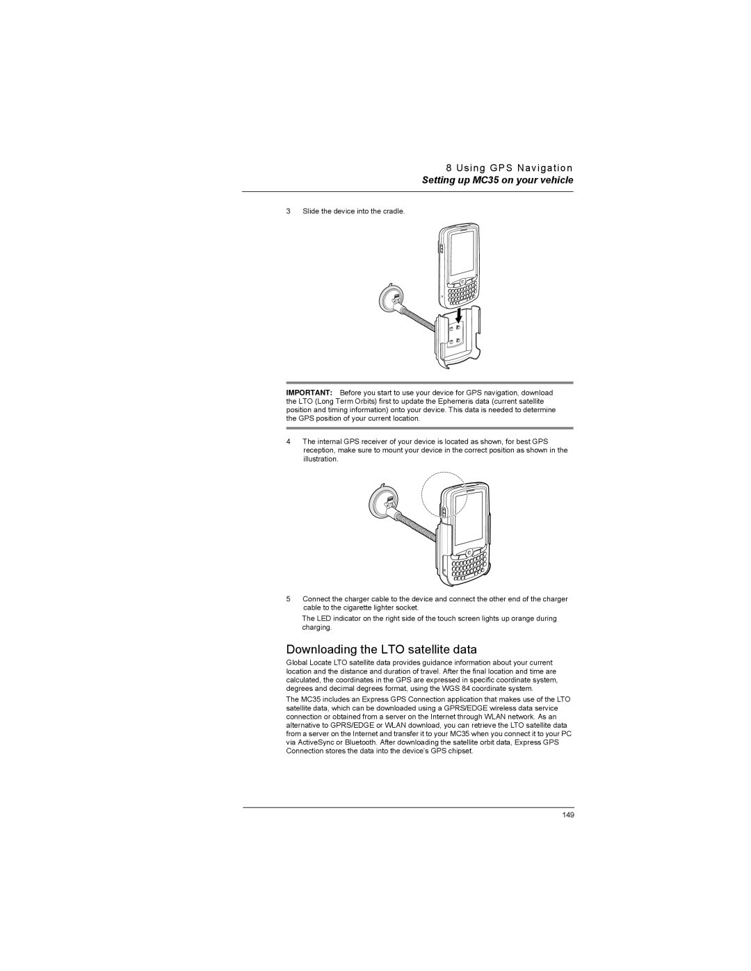
Setting up MC35 on your vehicle
Installation reminders
GPS antenna
Device mounting precautions
Setting up MC35 on your vehicle
Downloading the LTO satellite data
Tap Download Now
Using MC35 safely
Using MC35 safely
Driving precautions
152
Phone management programs
Using MC35 Companion Programs
Phone management programs
SIM Manager
Phone management programs
Tap Programs SIM Toolkit
SIM Toolkit
Tap Programs Gain Adjust
Wireless communication programs
Gain Adjust
Wireless communication programs
Tap Connect
Tap Programs Internet Sharing
Push to Talk
PTT menu
Tap Programs Push to Talk
Using PTT
On the PTT Menu screen, tap PTT Contacts Menu Add Contact
On the PTT Menu screen, tap PTT Contacts a contact Menu Edit
Tap Menu Leave Group
On the PTT Menu screen, tap PTT Contacts Menu Add Group
Tap Menu Delete Group
Tap Menu Rename Group
PTT calls
PTT Contacts status icons
Selected
Incoming, or Outgoing
Tap Menu Call Me Alert
Tap Menu My Availability turn it On or Off
Configuring the PTT Settings
Tap Programs Gprs Setting
Gprs Setting
Tap Programs Terminal Services Client
Terminal Services Client
On your PC, select Start Settings Control Panel
Express GPS Connect position fix times
Using Express GPS Connect
Express GPS Connect
Use Express GPS Connect for the first time
How to improve GPS performance
Express GPS Connect status icons
Downloading the Express GPS Connect Data File
To download the Express GPS Connect data file using Settings
Configuring the Express GPS Connect
WiFi Region Switch
Tap Advanced Factory Reset
Tap Programs WiFi Region Switch
Tap Programs Pictures & Videos
Media-related programs
Pictures & Videos
Media-related programs
Organizing photos and videos
Copying image files or video clips to your device
Thumbnail mode
Full screen mode
Tap Menu Zoom
Tap Menu Save As
Media-related programs
Thumbnail mode, tap Menu Play Slide Show
Slide show mode
Customizing Pictures & Videos
Media-related programs
Camera
Camera screen
Tap Programs Pictures & Videos Camera
Camera capture mode
Tap Menu Mode Timer
Tap Menu Mode Burst
Tap Menu Quality
Tap Menu Options Camera tab
Tap Programs CamWedge
Tap Programs Pictures & Videos
CamWedge
Configuring the CamWedge Settings
Media-related programs
Test Window
Log Window
Product download-related programs
AirBEAM Smart
Product download-related programs
AirBEAM License
Configuring the AirBEAM Smart Client
AirBEAM Package Builder
AirBEAM Smart Client
Tap Programs AirBEAM Tap File Configure
Product download-related programs
Product download-related programs
Product download-related programs
Product download-related programs
Synchronizing with the Server
Automatic Synchronization
Manual Synchronization
Rapid Deployment Client
Rapid Deployment Window
Tap Programs RDClient
Capturing RD Bar Codes
Tap Programs Download Agent
Download Agent
Customizing your MC35
Adjusting system preferences
Adjusting system preferences
Personal tab
Buttons
Input
Lock
MSN Options
Menus
Phone
Owner Information
Today
Sounds & Notification
System tab
About
Brightness
Clock & Alarms
Error reporting
Certificates
Phone Profiles
Memory
Regional Settings
Power
Remove Programs
Screen
SIM Manager
Connections tab
System Information
Beam
Bluetooth
Connections
Express GPS Connect
WiFi/Network Cards
WiFi Card Setting
USB to PC
Program management
Wireless Manager
Program management
Adding programs to your device
Open the path Windows Start Programs
Adding a program to the Start menu
Tap Remove
Removing programs
For information on Refer to
Customer support
User Support
Customer support
Locking the keypad/touch screen
Using system locks
Protecting your MC35
Protecting your MC35
Locking the device
Creating backup files
Tap Menu Edit Paste
Tap Menu Edit Copy
Troubleshooting
Troubleshooting
Troubleshooting reminders
Troubleshooting procedures
Memory problem
Password problem
Tapping and writing problems
Screen problems
Internet connection problem
IR connection problem
Bluetooth connection problem
Phone connection problem
USB cable problem
Recalibrating the screen
Resetting your MC35
Checking the OS version of your device
Tap Settings On the System tab, tap System Information
Battery pack reminders
Battery pack information
232
Index
Page
PTT
Word Mobile File list 81 Create 236
237
238
Page
72E-98506-03 Revision a October