3.15.4.1 Display Settings
With a NT+ chart installed, the display of the chart plotter is visually communicated to navigators as never before. To simplify the customization of the chart display, the map settings are now
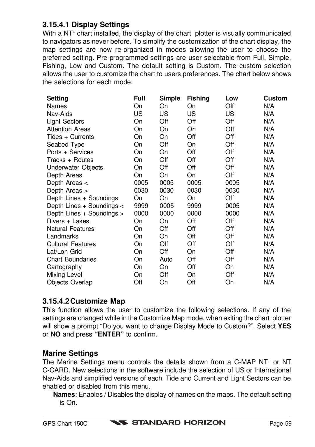
Setting | Full | Simple | Fishing | Low | Custom |
Names | On | On | On | Off | N/A |
US | US | US | US | N/A | |
Light Sectors | On | Off | Off | Off | N/A |
Attention Areas | On | On | On | Off | N/A |
Tides + Currents | On | On | Off | Off | N/A |
Seabed Type | On | Off | On | Off | N/A |
Ports + Services | On | On | Off | Off | N/A |
Tracks + Routes | On | Off | Off | Off | N/A |
Underwater Objects | On | Off | Off | Off | N/A |
Depth Areas | On | On | On | Off | N/A |
Depth Areas < | 0005 | 0005 | 0005 | 0005 | N/A |
Depth Areas > | 0030 | 0030 | 0030 | 0030 | N/A |
Depth Lines + Soundings | On | On | On | Off | N/A |
Depth Lines + Soundings < | 9999 | 0005 | 9999 | 0005 | N/A |
Depth Lines + Soundings > | 0000 | 0000 | 0000 | 0000 | N/A |
Rivers + Lakes | On | On | Off | Off | N/A |
Natural Features | On | Off | Off | Off | N/A |
Landmarks | On | On | Off | Off | N/A |
Cultural Features | On | Off | Off | Off | N/A |
Lat/Lon Grid | On | Off | On | Off | N/A |
Chart Boundaries | On | Auto | Off | Off | N/A |
Cartography | On | On | Off | On | N/A |
Mixing Level | On | Off | On | Off | N/A |
Objects Overlap | Off | On | Off | On | N/A |
3.15.4.2 Customize Map
This function allows the user to customize the following selections. If any of the settings are changed while in the Customize Map mode, when exiting the chart plotter will show a prompt “Do you want to change Display Mode to Custom?”. Select YES or NO and press “ENTER” to confirm.
Marine Settings
The Marine Settings menu controls the details shown from a
Names: Enables / Disables the display of names on the maps. The default setting is On.
GPS Chart 150C |
| Page 59 |
|