Manual
Card
Programs
Symbols used in this Manual
205 Road Plus 249 File Editor 303 Monitoring 333 Index 341
View of chapters
Contents
Select Stakeout Method Plot Configuration
Introduction Measure Mode Results Configuration
Introduction Search Point Coarse Positioning
Stakeout
Hidden Point 111
Remote Height 105
Area Computation of Area 117
Sets of Angles 129
Road line 171
Local Resection 165
205
Road Plus 249
Index 341
File Editor 303
Monitoring 333
General
Introduction
Hardware and software required
Installation in the PC
TPS-WORKBENCH
On the diskette bearing the label TPS 1000/2000/5000
System Firmware
Diskette bearing the label TPS
????? Maximum of 5 characters for name Application
Application programs ?????VVV.PRG
Characters for version release number
System textsSYS?VVV.SS
TIEVVV.LENetc
PrtxtVVV.LSP Orientation
RESECVVV.LENetc Stakeout
STAKEVVV.LENetc
Loading files into the TPS1000 instruments
Applications Name Art.No Licence Code Version Language
Menu
Select the command Transfer files in the Utilities
Loading system texts
Programs
Loading application
Licence code Solving problems
Select Main Menu
List
No. of application Licence code Remarks
Licence code for TPS 1000 applications
Units in this manual Preparation
Settings
General notes
Data exchange
Using the program
Instrument field setup
Calling up the program
Target eccentricity
Designation of keys
Introduction
Orientation and Height Transfer
Enter the target point number and height of the reflector
Target Point
Enter a maximum of 10 points. The same point can be
Point List
Retrieved several times
Return to the dialog Target Point
Measure Mode
Respective standard deviations
Calculation
Calculates the orientation, the elevation
More Information
Can also disable points from the calculation
Display the residuals of individual measurements. You
Orientation or height as well as delete erroneous
Status
Use for Ht
Point no
Easting, Northing, Elevation Target coordinates used
Recalculate the result and return to the dialog
Plot
Start the Configuration Editor from the Target Point dialog
Configuration
Configuration Editor
User Disp
Two Faces
Log File
Log FlName
Log file
Dual-face Measurement
Data will always be appended to the specified Log
File
For each measurement, a record will be
Record
This manual describes the Resection program
Resection
TPS System 1000 theodolite series
Pt2 00000
Enter station point number and height of the instrument
Proceed to the dialog Target PoinT Start the Configuration
Station Data
Reflector
Enter the target point number and height
RESEC\ Measure MOD GSI
Shown with the orientation
This dialog the calculated station coordinates are
TPS-System 1000 Programs-2.3.1en
Start the Configuration Editor from the Station Data dialog
TPS-System 1000 Programs-2.3.1en
For each measurement, a record will
Data will always be appended to the specified Log-file
Be stored containing
Station coordinates and orientation
Typical log file entry in the Resection program
Tie Distance
Radial Mode
TIED\ First Point
TPS-System 1000 Programs-2.3.1en
Results
TPS-System 1000 Programs-2.3.1en
Start the Configuration Editor from the First Point dialog
TPS-System 1000 Programs-2.3.1en
Log File
FILE12.GSI
Introduction Search Point
Stakeout
Line Offset
Coarse Positioning
For positioning are only displayed after two stakeout
Points
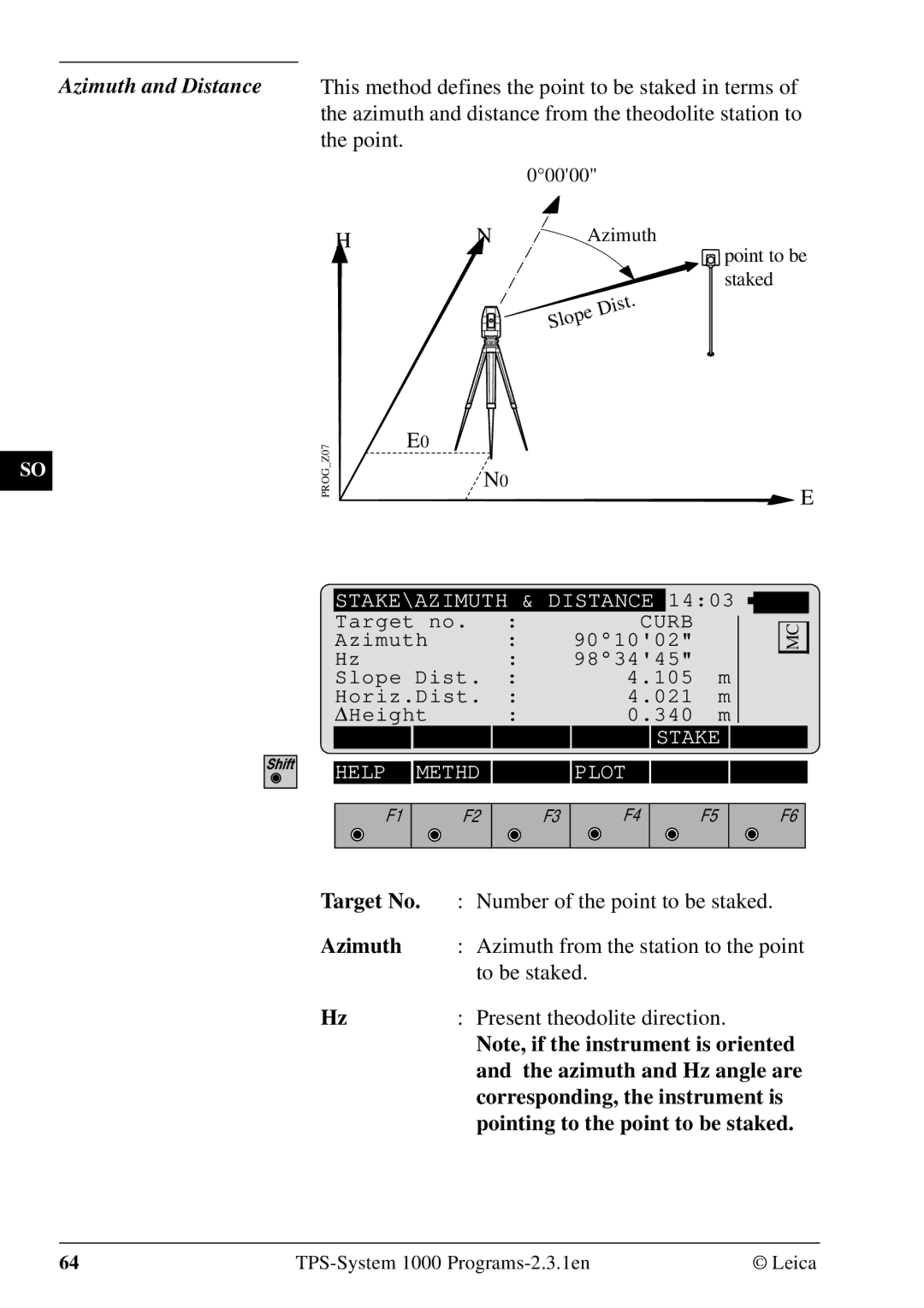
Azimuth
Target no
Line
Offset
Orthogonal
Hz Angle
STAKE\AZIMUTH & Distance
Leica TPS-System 1000 Programs-2.3.1en
Polar Stakeout
Stakeout
Dist
Right
Transversal displacement
Reflector. Positive in sign if point is
Point is further away from station
Longitudinal displacement
Reflector. Positive in sign if stakeout
Target no Point number of the point to be staked
Stakeout with auxiliary points
Stakeout point
Angle from the first auxiliary point to
Distance from the first auxiliary point
To the stakeout point
Stakeout from Coordinate Differences
Leica TPS-System 1000 Programs-2.3.1en
Stakeout M
Select Stakeout Method
Coarse Meth
Numeric values, corresponding to
Plot is generated of the stakeout situation with a list
3D Stake
Coordinates, setout height and height
Recording of design
Difference in the log file
Coordinates, setout coordinates und
Typical log file entry in the Stakeout program
Free Station
Station Data Target Point
Without new input
Same point number can be used several times
FREST\MEASURRE Mode GSI1403
Well as the standard deviation of the results
Calculates the 3D station coordinates and orientation as
Orient Standard deviation of the Orientation
Distance error
Can also disable points from the calculation of position
Or height as well as delete erroneous measured points
Sequence number of the current point
Easting, Northing, Elevation Target coordinates used
Generates a plot showing the measurement
Configuration. The station point is in the center
Top of the sketch shows the direction of Grid north.
Sketch is true in angular but not true in distances. Points
FREST\ Configuration
Leica TPS-System 1000 Programs-2.3.1en
Height of station
Easting
Northing
Next
Typical log file entry in the Free Station program
Reference Line
ΔPerp.l
ΔLine
ΔSpat.dist
Determine Base Points
Baseline Points
1403 Puoint no
Change the theodolite face Exit the program
Alpha
ΔPerp.lngth
Height reference point
Length of perpendicular
Spatial distance
100
Line / α
If set to Inter, the Line / a option is
Height
Each modification of baseline Reference line is stored
Configuration
104
Remote Height
Point number of the base point
Measure Base Point
Horizontal direction from the remote
Point to the base point
107
Slope dist
109
REMHT\ Configuration
Reflector 1 + Reflector Reflector 3 + Reflector
Hidden Point
Start the Configuration Editor from the Measure dialog
Measure ROD Configuration
Measure Rod
Point
Point number
Horizontal direction to the hidden
Slope. Dist
System 1000 theodolite series
Area Computation of Area
This manual describes the Area program of the TPS
Straight line
119
Ensure the central angle of any arc is always smaller
Arcs
Than 180 200 gon
Three Points
Radius Arc
Select arc defined by 2 points and radius Exit the program
Accept the input. Continue with dialog Measure
Calculation
Return to the dialog Results
Area results recording format
Shows a plot of the present area
Code
Set YES for dual-face measurement
126
Distance and azimuth are stored
For each section of the area, start
Point and end point, horizontal
128
Sets of Angles
Sets menu view
Sets Menu
Measure First Set
Measure Mode
A new instrument station. The point number for
Targets must be entered in Dialog First SET
ALL Dist
Measure Further Set
ΔHz
Calculate Horizontal and Vertical Sets
Calculate Mode
Number of measurements and accuracies
Formats and Data Recording
Differences or residuals for the points observed
Directions averaged from all valid sets
Code Target number Average of all sets
SETS\ More Info HZ
More Information
139
MR= Σv² = ±2 1s-1 13-1 MM = = ±1
Examples and used formulae
PtNr Face Average face Average d = d a +II a
MR= Σv² = ±2 MM = = ±1
Used formulae and designations
Start the Configuration Editor from the Sets Menu dialog
Angle Tol
Hz Tol
Angles of all sets, the standard
Average horizontal and vertical
Deviation for one measurement
Standard deviation of an angle
146
Traverse
Traverse menu
Traverse Menu
New traverse
Select method of orientation
Calculate Azimuth
Enter Backsight Azimuth
Occupy station
154
Traverse Point / Sideshot Point
Close traverse
157
Code
Examples Codeblock with results of the traverse closure
Number of traverse points
Length of traverse sum of legs
Return to the dialog Closure Results
Plot
Measurement
Mult Meas Set YES for the multiple
No for the single measurement
Input of code number for recording
Measurement to a point can be repeated as often as
Multiple Measurement
Desired to achieve a higher accuracy or reliability.
Mean value of the measurements and the respective
162
This program, information about
Header line will contain the name
Instrument, the name of the data file
Date and time
164
Local Resection
LRES\ Station Data
Target Points
Station no
LRES\ Configuration
170
Manual describes the program Road Line for
Road line
Leica TPS 1000 series
Centre-line offset
File name PRF?????.GSI
File name ALN?????.GSI
File name CRS?????.GSI
Permitted elements in the Hz-alignment Straight
Permitted elements in cross sections
Permitted elements in V-alignments Straight
Parabola
Alignment Calculation program only
Program concept
Alignment
Out or inspected in two dimensions. Without
Selection of files
If no V-alignment is selected, points can only be set
Are found, the inspection is aborted
Checking files
177
Program flow
Element
Cross sections Selecting points in the cross section
By this amount
Horizontal displacement centre-line
Offset of the centre of the X-section
Returns to dialog Cross Section
Plot
ROADL\ Point Coords
Stakeout
Section Check
ROADL\ X-SECTION Check
Chainage
Display of results
Result of the road station and offset is stored
ALN Files dialog
Start the Configuration Editor from the Select
189
Measurement
191
Hz-alignment
Data format
193
Lasttmpl
Data block
195
410001+Example1
Example S-line with a straight connection
110002+00000000
00100000 73....+Tmpl0123
Alignment V-alignment definition = V-alignment
198
72 = 00000NON
410001+Example1 +0VALIGNM
Example Crest and dip
01142936 83..10+00422500
+02091126 83..10+00415000
Aspect Chainage increasing
Cross sections
202
Empty
Using the ROADDATA.EXE program
Leica ROADDATA.EXE for providing setting-out data files
Road Data Entry program
\roaddata
Cogo
206
Direc. Type
Call up the Configuration-Editor
Search Given
Computes distance and direction between two points
Call up the function in the Cogo Menu dialog
Horiz.Dist
From
Southwest
From a known point
Traverse
Computes a new point given a direction and distance
Call up the function from the Cogo Menu
Quadrant
Defining direction by magnetic bearing
Northeast
Polar calculation
Divide
Multiply
Add
Subtract
Azimuth
Defining direction by
Accept displayed values and proceed to dialogue Traverse
Display of entered Azimuth ref. to
Display of corrected Azimuth
Horiz Dist
Defining horizontal distance
Entering horizontal distance
Call up of a distance which has been
Entering distance for a positive
Display of entered horizontal distance
Correction
Entering distance for a negative
Following dialog box shows the result of the traverse
Intersections
Bearing-Bearing Intersection
Intersections
Call up the function from the menu
Enter quadrant First or second
Configuration during Direc.Type
Straight lines
Enter magnetic bearing First or
Enter bearing, mangnetic bearing resp
Configuration during Direc
Azimuth if Azimuth is selected
Type
COGO\BRG-BRG Results
Search
Bearing-Distance Intersection
Bearing-bearing coordinates
S1 and S2 Y
COGO\ Bearing from
Then the azimuth of the straight line
Enter quadrant
Can be entered
Determining the direction by means of the function
Resp. azimuth if Azimuth is
Selected in the configuration during
Enter bearing, mangnetic bearing
Call up of a radius which has been
Enter distance from point
Entering radius
COGO\ BRG-DIST Results
Point 2 Y, X, radius
Distance-Distance Intersection
Point 1 Y, X, radius
COGO\ Distance #1 from
Enter distance from points
COGO\ DIST-DIST Results
Call up the function in the Cogo Menu
Offsets
Baseline Start Point 1 Y
Distance-Offset
Baseline End Point 2 Y
Lateral point 3 Y
Call up the function from the menu Offsets
Offset Display lateral deviation/ordinate Q
Following dialog box shows the results
Lateral point 3 coordinates Y
Orthogonal point calculation
242
Enter distance along baseline L
Using the function Polar
Entering distance along baseline
Call up of a distance along baseline
Enter lateral deviation/distance from start Q
Stored using the function Polar
Entering lateral deviation/distance
From start
Display of east coordinate
Entering point number of the lateral
Display of north coordinate
Entering height optional
Arc point 1 Y
Three Point Arc
Circle centre coordinates
COGO\ First PT on ARC
Following dialog box shows the results of the calculation
Alignment Definition Data Files
Road Plus
250
= crest + = dip
Defined by chainage and height
Parameters of parabola
Number of points in a cross section
Creating Data Files Program Overview
Getting Started
ROAD+\ Configuration
255
List Help Conf
Horizontal alignment file contains the following elements
Cross section Cut
Cross Section Definition
Negative offset Positive offset
Cross section Fill
Cross Section name Starting Chainage
Cross Section Assignment File
Interpolation between cross sections
Cross Section Interpolation
Interpolation along a cross section
Cross Section D Full Superelevation Cross Section C
Superelevation/Widening
Superelvation governed by cross sections
Station Equation File
File Checking
Preparing for the example
Stakeout Using Horizon- tal Offset
265
266
Tutor 35.000 16.700 500 030 TypCut 16.630
Slope extends well beyond expected Catch Point
Template SCLO
ROAD+\ Chainage & Offset
Hght Offset
Offset
Access the cross section options
Horizontal offset to apply to current
Interpolated
Interpolated
Horizontal
Previous Element
Activates the stakeout program
Stakeout and Record point
1403 Target no 00000 Dist 007 Height
Stakeout Next point on Cross Section
276
Check Xsec Help
25.000
500 Easting 331.000 Northing 340.500 Elevation 31.200
Horizontal Offset Stake Out Summary
Start Roadplus & Set Configuration Options
Horizontal file must be selected
Select Alignment Files
Set offset value and select point to stakeout
Stakeout the point
Select new chainage
Cross Section +200.000 Centerline
Slope Staking
Plan View
CL Offset Catch Point ΔXS Hgt Diff
Catch Centr Help Plot
287
Slope Staking Menu Function Key Summary
Reference Point
290
Horizontal Alignment
Data Formats
Following geometric elements are supported
Element Definition Declaration Alignment file
Comments
Example of a Horizontal Alignment
Tangent Coordinate Km,H to Coordinate Km,H
Vertical Alignment
Parabola length End of project Coordinate Km,H 00000EOP
Vertical Alignment File Header
Example of a vertical alignment file
Geometric elements supported
Cross Sections
Element Definition
Header of the cross section file
+TEMPLATE
Example
Header of the Cross Section Assignment file
Cross Section Assignments
Elements supported Definition
+CRSASKER
Elements supported
Station Equations
Header of the Station Equation file
Data block for a station equation is structured as follows
301
302
Creation of files
File Editor
It is possible to insert also a new data set
Editing files
Start program File Editor from the Main
Open file
Menu Programs dialog
File Type Select type of file Coordinate, refer to chapter
Insert code block, see dialog
Coordinates
Goto start of file Goto end of file
Call function Insert Point Coordinates in menu Insert Record
Save
Sequence number of current point
Call function Insert Code Block in menu Insert
Input of code number
Info
File pages 307
Start dialog Search in dialogs View / Edit
Insert new Header, see dialog
File Type
Job Id
File Id
Insert Curve In, see dialog
Ele Type
Station
Radius
Template
315
Direction Forward
Start dialog Search in the dialogs View / Edit
Searching for station
Input of station chainage Search for station
0VALIGNM
Insert Tangent Insert Circular Curve
Display for the vertical alignment file
Parameter
Call function Insert Parabola in menu Insert
Input of parabola parameter
Input of elevation
File pages 317
Template
Display of cross section file
SO Ht diff
ΔHz-Dist
Cut/Fill
Slope ratio
File pages 322
Station Equation
Display for the station equation file
Input of job identificaton
Back
Sta. Eqn
Ahead
Pages 326
Start dialog Search in dialogs View / Edit File
Cross-section Assignment
Selection of relevant cross section file
Display of section assignment file
CRS File
Input of start station for this template
Selection of template
Station Input of station chainage
Pages 330
Monitoring
334
Main menu
Selecting points
Points will be saved in the set measurement file
Measurement menu
Selecting the points to be measured
Timer selection
Point measurement End monitoring
Index
342
343
Section Check 184
Transfer
ISO standard
664901-2.3.1en